Constitution Hill, London

Last updated
Constitution Hill from Wellington Arch, with the Memorial Gates visible (2012) Constitution Hill.jpg
Constitution Hill from Wellington Arch, with the Memorial Gates visible (2012)

Constitution Hill is a road in the City of Westminster in London. It connects the western end of The Mall (just in front of Buckingham Palace) with Hyde Park Corner, and is bordered by Buckingham Palace Gardens to the south, and Green Park to the north. At the top of the rise in the roadway at the Corner is the Wellington Arch, near where the road is flanked by the Memorial Gates war memorial. [1]

Contents

Name

The origin of the name is uncertain. Parliamentary records from 1642 show a reference to "a small redoubt and battery on Constitution Hill". [2] One theory is that King Charles II had a habit of taking "constitutional" walks there. [1] In Strype's Map, 1720, it is marked "Road to Kensington". In John Smith's map of 1724, it is called "Constitution Hill". [3]

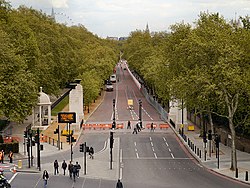
An old lane on this route was widened in connection with the development of Buckingham Palace in the 1820s by John Nash. It formed a processional route from the palace to Hyde Park. [4] It is now closed to traffic on Sundays and public holidays. [1]

History

One account has Charles' brother, James, Duke of York returning from a hunt on Hounslow Heath and stopping his coach along Constitution Hill to avoid hitting the king walking across the road. Upon wondering if Charles put himself in danger by walking out in front of a vehicle, the King replied, "No danger whatever, James, for I am sure that no man in England would take my life to make you king." [2]

Constitution Hill was a popular spot for duels. On 11 January 1696, Sir Henry Colt, 1st Baronet was challenged to a duel by Robert "Beau" Fielding (future husband of Charles II's mistress Barbara Palmer, 1st Duchess of Cleveland), near what is now the site of Bridgewater House. Fielding injured the Baronet, but was subsequently disarmed, ending the fight. In 1730, William Pulteney, 1st Earl of Bath duelled with John Hervey, 2nd Baron Hervey. [2]

The area was the scene of three assassination attempts on Queen Victoria—in 1840 (by Edward Oxford), 1842 (by John Francis) and 1849 (by William Hamilton). In 1850, the former Conservative Prime Minister Sir Robert Peel was thrown from his horse on Constitution Hill by the gate into Green Park; he suffered a fatal injury and died three days later. [1]

Wellington Arch at Hyde Park Corner sits at the end of the road by Apsley House. It was designed by Decimus Burton and completed in 1828. A major restoration project by English Heritage was undertaken between 1999 and 2001. [5] In 2002, war memorial to over five million Commonwealth soldiers, including India, Pakistan, Bangladesh, Sri Lanka, Africa, Caribbean and Nepal, was constructed near the top of Constitution Hill, just before Hyde Park Corner; the memorial is known as the Memorial Gates. It was opened by Queen Elizabeth II on 6 November. [1]

Large concrete lamp posts were installed in Constitution Hill in the 1960s. Thanks to the swift intervention of comedian and enthusiastic environmentalist Spike Milligan they were removed within days and the old gas lamps are still there. [6]

Notes

Citations

  1. 1 2 3 4 5 Weinreb et al. 2008, p. 205.
  2. 1 2 3 Edward Walford, 'St James St and neighbourhood', in Old and New London: Volume 4 (London, 1878), pp. 165-181. British History Online http://www.british-history.ac.uk/old-new-london/vol4/pp165-181 [accessed 28 August 2020].
  3. Wheatley 1891, p. 452.
  4. "About Green Park : Landscape History". royalparks.org.uk. Retrieved 30 August 2020.
  5. Weinreb et al. 2008, p. 996.
  6. "My obituary, by Spike Milligan". Evening Standard . 27 February 2002. Retrieved 26 April 2020.

Sources

51°30′09″N0°08′47″W / 51.5024°N 0.1464°W / 51.5024; -0.1464

Related Research Articles

<span class="mw-page-title-main">Whitehall</span> Road in the City of Westminster, in Central London

Whitehall is a road and area in the City of Westminster, Central London, England. The road forms the first part of the A3212 road from Trafalgar Square to Chelsea. It is the main thoroughfare running south from Trafalgar Square towards Parliament Square. The street is recognised as the centre of the Government of the United Kingdom and is lined with numerous departments and ministries, including the Ministry of Defence, Horse Guards and the Cabinet Office. Consequently, the name "Whitehall" is used as a metonym for the British civil service and government, and as the geographic name for the surrounding area.

<span class="mw-page-title-main">The Mall, London</span> Road in London, England

<span class="mw-page-title-main">Hyde Park, London</span> Royal Park in London, United Kingdom

Hyde Park is a 350 acres (140 ha), historic Grade I-listed urban park in Westminster, Greater London. A Royal Park, it is the largest of the parks and green spaces that form a chain from Kensington Palace through Kensington Gardens and Hyde Park, via Hyde Park Corner and Green Park, past Buckingham Palace to St James's Park. Hyde Park is divided by the Serpentine and the Long Water lakes.

<span class="mw-page-title-main">Green Park</span> Royal park in London, England

The Green Park, one of the Royal Parks of London, is in the City of Westminster, Central London. Across Constitution Hill road, Green Park is to the north of the gardens and semi-circular forecourt of Buckingham Palace. The park is in the middle of a near-continuous chain of green spaces in Westminster that includes St James's Park, Hyde Park, and Kensington Gardens. To the northwest of Green Park is the district of St James's including, Lancaster House, Clarence House, and St James's Palace.

<span class="mw-page-title-main">Piccadilly</span> Road in the City of Westminster, London, England

Piccadilly is a road in the City of Westminster, London, England, to the south of Mayfair, between Hyde Park Corner in the west and Piccadilly Circus in the east. It is part of the A4 road that connects central London to Hammersmith, Earl's Court, Heathrow Airport and the M4 motorway westward. St James's is to the south of the eastern section, while the western section is built up only on the northern side. Piccadilly is just under 1 mile (1.6 km) in length, and it is one of the widest and straightest streets in central London.

<span class="mw-page-title-main">Regent's Park</span> Royal Park in London, England

Regent's Park is one of the Royal Parks of London. It occupies 410 acres (170 ha) of high ground in north-west Inner London, administratively split between the City of Westminster and the Borough of Camden. In addition to its large central parkland and ornamental lake, it contains various structures and organizations both public and private, generally on its periphery, including Regent's University and London Zoo.

<span class="mw-page-title-main">Marble Arch</span> Monument in London, England

The Marble Arch is a 19th-century white marble-faced triumphal arch in London, England. The structure was designed by John Nash in 1827 as the state entrance to the cour d'honneur of Buckingham Palace; it stood near the site of what is today the three-bayed, central projection of the palace containing the well-known balcony. In 1851, on the initiative of architect and urban planner Decimus Burton, a one-time pupil of John Nash, the arch was relocated to its current site, near the northeast corner of Hyde Park, so that expansion of Buckingham Palace could proceed.

<span class="mw-page-title-main">Belgravia</span> District in Greater London, England

Belgravia is a district in Central London, covering parts of the areas of the City of Westminster and the Royal Borough of Kensington and Chelsea.

<span class="mw-page-title-main">Hyde Park Corner</span>

<span class="mw-page-title-main">Clarence House</span> Royal residence in London

Clarence House is a royal residence on The Mall in the City of Westminster, London. It was built in 1825–1827, adjacent to St James's Palace, for the royal Duke of Clarence, the future King William IV.

<span class="mw-page-title-main">Buckingham Palace Garden</span> Garden in London

Buckingham Palace Garden is a large private park attached to the London residence of the British monarch. It is situated to the rear (west) of Buckingham Palace, occupying a 17-hectare (42-acre) site in the City of Westminster and forms the largest private garden in London. It is bounded by Constitution Hill to the north, Hyde Park Corner to the west, Grosvenor Place to the south-west, and the Royal Mews, Queen's Gallery, and Buckingham Palace itself to the south and east.

<span class="mw-page-title-main">Farringdon Road</span>

Farringdon Road is a road in Clerkenwell, London.

<span class="mw-page-title-main">Pall Mall, London</span> Street in Central London

Pall Mall is a street in the St James's area of the City of Westminster, Central London. It connects St James's Street to Trafalgar Square and is a section of the regional A4 road. The street's name is derived from pall-mall, a ball game played there during the 17th century, which in turn is derived from the Italian pallamaglio, literally "ball-mallet".

<span class="mw-page-title-main">Wellington Arch</span> Triumphal arch in London

The Wellington Arch, also known as the Constitution Arch or (originally) as the Green Park Arch, is a Grade I-listed triumphal arch by Decimus Burton that forms a centrepiece of Hyde Park Corner in central London, between the corner where Hyde Park meets Green Park. The Arch stands on a large green-space traffic island with crossings for pedestrian access. From its construction (1826–1830) the arch stood in a nearby location, slightly to the east, directly across from Burton's Ionic screen entrance to Hyde Park; it was moved a short distance to its current site at the top of the Constitution Hill road in 1882–1883. The triumphal arch originally supported a colossal equestrian statue of the 1st Duke of Wellington by the sculptor Matthew Cotes Wyatt, acquiring its name as a result. Peace descending on the Quadriga of War by sculptor Adrian Jones, a bronze of the Goddess of Victory Nike riding a quadriga, has surmounted the arch since 1912.

<span class="mw-page-title-main">Bayswater Road</span> Road in west London, running along the northern boundary of Hyde Park

<span class="mw-page-title-main">Rotten Row</span> Road and bridleway in Hyde Park, London

Rotten Row is a broad track running 1,384 metres (4,541 ft) along the south side of Hyde Park in London. It leads from Hyde Park Corner to Serpentine Road. During the 18th and 19th centuries, Rotten Row was a fashionable place for upper-class Londoners to be seen horse riding. Today it is maintained as a place to ride horses in the centre of London, but it is little used as such.

<span class="mw-page-title-main">Mandarin Oriental Hyde Park, London</span> Building in London, England

Mandarin Oriental Hyde Park, London, is a five-star hotel, located in the Knightsbridge area of London, owned and managed by Mandarin Oriental Hotel Group. Housed in a historic, Edwardian-style building, the hotel originally opened in 1908 as the Hyde Park Hotel and in 1996 the Mandarin Oriental Hotel Group purchased the property and conducted a full renovation, consequently re-opening in May 2000.

<span class="mw-page-title-main">Old Burlington Street</span>

Old Burlington Street is a street in central London that is on land that was once part of the Burlington Estate.

<span class="mw-page-title-main">Orme Square</span>

Orme Square is a private square in Bayswater, London, England, off the north side of Bayswater Road and on the north-west corner of Hyde Park, overlooking Kensington Gardens whose Orme Gate entrance takes its name from the square.

<span class="mw-page-title-main">Chalk Farm Tavern</span> Former public house in Primrose Hill, London

The Chalk Farm Tavern was a public house located in what is today Regent's Park Road in Primrose Hill, London.