Abel Janszoon Tasman was a Dutch seafarer, explorer, and merchant, best known for his voyages of 1642 and 1644 in the service of the Dutch East India Company (VOC). He was the first known European explorer to reach the islands of Van Diemen's Land, Fiji and New Zealand.

Captain George Vancouver was a British officer of the Royal Navy best known for his 1791–95 expedition, which explored and charted North America's northwestern Pacific Coast regions, including the coasts of what are now the American states of Alaska, Washington, and Oregon, as well as the Canadian province of British Columbia. He also explored the Hawaiian Islands and the southwest coast of Australia.

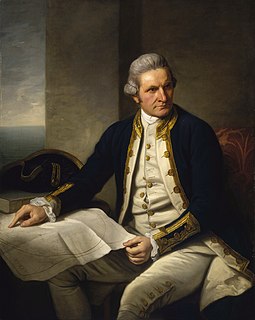
Captain James Cook was a British explorer, navigator, cartographer, and captain in the British Royal Navy, famous for his three voyages between 1768 and 1779 in the Pacific Ocean and to Australia in particular. He made detailed maps of Newfoundland prior to making three voyages to the Pacific, during which he achieved the first recorded European contact with the eastern coastline of Australia and the Hawaiian Islands, and the first recorded circumnavigation of New Zealand.

The Kerguelen Islands, also known as the Desolation Islands, are a group of islands in the Antarctic constituting one of the two exposed parts of the Kerguelen Plateau, a large igneous province mostly submerged by the southern Indian Ocean. They are among the most isolated places on Earth, located more than 3,300 km (2,100 mi) from Madagascar. The islands, along with Adélie Land, the Crozet Islands, Amsterdam and Saint Paul Islands, and France's Scattered Islands in the Indian Ocean, are part of the French Southern and Antarctic Lands and are administered as a separate district.

The Northwest Passage (NWP) is the sea route between the Atlantic and Pacific oceans through the Arctic Ocean, along the northern coast of North America via waterways through the Canadian Arctic Archipelago. The eastern route along the Arctic coasts of Norway and Siberia is accordingly called the Northeast Passage (NEP).

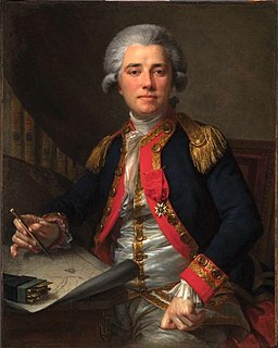
Jean François de Galaup, comte de Lapérouse was a French naval officer and explorer whose expedition vanished in Oceania.

Tahiti is the largest island of the Windward group of the Society Islands in French Polynesia, located in the central part of the Pacific Ocean. Divided into two parts, Tahiti Nui and Tahiti Iti, the island was formed from volcanic activity; it is high and mountainous with surrounding coral reefs. Its population is 189,517 inhabitants, making it the most populous island of French Polynesia and accounting for 68.7% of its total population.

HMS Endeavour, also known as HM Bark Endeavour, was a British Royal Navy research vessel that Lieutenant James Cook commanded to Australia and New Zealand on his first voyage of discovery from 1768 to 1771.

The Bay of Islands is an area on the east coast of the Far North District of the North Island of New Zealand. It is one of the most popular fishing, sailing and tourist destinations in the country, and has been renowned internationally for its big-game fishing since American author Zane Grey publicised it in the 1930s. It is 60 km (37 mi) north-west of the city of Whangarei. Cape Reinga, at the northern tip of the country, is about 210 km (130 mi) by road further to the north-west.

Mo'orea, also spelled Moorea, is a volcanic island in French Polynesia. It is one of the Windward Islands, a group that is part of the Society Islands, 17 kilometres (11 mi) northwest of Tahiti. The name comes from the Tahitian word Mo'ore'a, meaning "yellow lizard": Mo'o = lizard ; Re'a = yellow. An older name for the island is 'Aimeho, sometimes spelled 'Aimeo or 'Eimeo. Early Western colonists and voyagers also referred to Mo'orea as York Island.

Adelaide Island is a large, mainly ice-covered island, 139 kilometres (75 nmi) long and 37 kilometres (20 nmi) wide, lying at the north side of Marguerite Bay off the west coast of the Antarctic Peninsula. The Ginger Islands lie off the southern end. Mount Bodys is the easternmost mountain on Adelaide Island, rising to over 1,220 m. The island lies within the Argentine, British and Chilean Antarctic claims.

The first voyage of James Cook was a combined Royal Navy and Royal Society expedition to the south Pacific Ocean aboard HMS Endeavour, from 1768 to 1771. It was the first of three Pacific voyages of which James Cook was the commander. The aims of this first expedition were to observe the 1769 transit of Venus across the Sun, and to seek evidence of the postulated Terra Australis Incognita or "undiscovered southern land".

Roger Curtis Green was an American-born, New Zealand-based archaeologist, Professor Emeritus at The University of Auckland, and member of the National Academy of Sciences and Royal Society of New Zealand. He was awarded the Hector and Marsden Medals and was an Officer of the New Zealand Order of Merit for his contributions to the study of Pacific culture history.

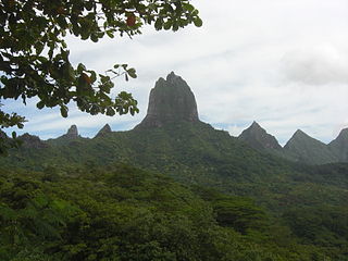
Mount Tohivea is a volcanic peak and the highest point on the island of Moorea in French Polynesia at 1,207 metres (3,960 ft). On its slopes are many streams and fertile soils. There are hiking trails along the summit close to Belvedere Point where people can view Mont Routui and the two bays and three peninsulas of Moorea. Mount Tohivea is a dormant volcano that is easily visible from Papeete, the capital of French Polynesia. The surrounding peaks are almost as tall as Mount Tohivea.
Opunohu Bay is a 3-km long bay on the island of Moorea, Tahiti. The water is 80 metres deep at the mouth. The bay is subject to wind-driven currents and upwellings. Sailboats and tour boats regularly enter the bay. Opunohu bay is west of Cook's Bay and Pao Pao.
The King George's Sound Company, also known as Richard Cadman Etches and Company after its "prime mover and principal investor", was an English company formed in 1785 to engage in the maritime fur trade on the northwest coast of North America. The company had nine partners in 1785: Richard Cadman Etches, John Hanning, William Etches, Mary Camilla Brook, William Etches, John Etches, Nathaniel Gilmour, Nathaniel Portlock (captain), and George Dixon (captain). No change in the list of partners after 1785 has been found.

James Cook's third and final voyage took the route from Plymouth via Cape Town and Tenerife to New Zealand and the Hawaiian Islands, and along the North American coast to the Bering Strait.

Pao Pao is an associated commune on the island of Mo'orea, in French Polynesia. It is part of the commune Moorea-Maiao. According to a census in 2007, it had a population of 4,244 people. According to the 2012 census, it had grown to a population 4,580 people. In the 2017 census, it had grown to a population of 4,639. It is the largest village in Mo'orea.
Matavai Bay is a bay on the north coast of Tahiti, the largest island in the Windward group of French Polynesia. It is in the commune of Mahina, approximately 8 km east of the capital Pape'ete.

Point Venus is a peninsula on the north coast of Tahiti, the largest island in the Windward group of French Polynesia. It is in the commune of Mahina, approximately 8 km east of the capital Pape'ete. It lies at the northeast end of Matavai Bay.


