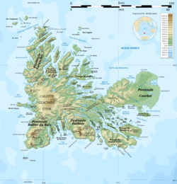
Cook Ice Cap

Last updated
Cook Ice Cap
Calotte Glaciaire Cook
Glacier Cook ISS035.JPG
Aerial view of the ice cap.
Indian Ocean laea relief location map.jpg
Red pog.svg
Type Ice cap
Coordinates 49°18′50″S69°02′29″E / 49.31389°S 69.04139°E / -49.31389; 69.04139 Coordinates: 49°18′50″S69°02′29″E / 49.31389°S 69.04139°E / -49.31389; 69.04139
Area400 km2 (150 sq mi)
Length28 kilometres (17 mi)
Thickness400 m (1,300 ft) average
TerminusOutlet glaciers
StatusRetreating
Cook Ice Cap

The Cook Ice Cap or Cook Glacier (French : Calotte Glaciaire Cook [1] or Glacier Cook) is a large ice cap in the Kerguelen Islands in the French Southern Territories zone of the far Southern Indian Ocean.

Contents

Geography

The Cook Ice Cap reaches a maximum elevation of 1,049 metres (3,442 ft) in its central area. [2] It had a surface of approximately 500 km2 (190 sq mi) in 1963, having shrunk to about 400 km2 (150 sq mi) in recent times. [3]

Named after British explorer James Cook (1728–1779), on French navigational charts of the early 20th century this ice cap appears as 'Glacier Richthofen' [4]

Location in Grande-Terre (Kerguelen) . Kerguelen CookGlacier 2.jpg
Location in Grande-Terre (Kerguelen) .
Glacier terminus at the southern end. Kerguelen CookGlacier.JPG
Glacier terminus at the southern end.

Glaciers

About sixty glaciers flow from the inner ice cap in a roughly radial pattern. At the feet of the snout of these outlet glaciers there are often terminal moraines with dammed lakes of varying sizes. Further down the glacial meltwaters have formed numerous outwash plains at certain, mostly inland, locations. Only one of the glaciers originating in the Cook Ice Cap has its terminus in the Indian Ocean at the Anse des Glaçons in southeastern Kerguelen's deeply indented coastline. [3]

The following are the main glaciers listed clockwise:

See also

Related Research Articles

<span class="mw-page-title-main">French Southern and Antarctic Lands</span> Overseas Territory of France

The French Southern and Antarctic Lands is an Overseas Territory of France. It consists of:

  1. Adélie Land, the French claim on the continent of Antarctica.
  2. Crozet Islands, a group in the southern Indian Ocean, south of Madagascar.
  3. Kerguelen Islands, a group of volcanic islands in the southern Indian Ocean, southeast of Africa.
  4. Saint Paul and Amsterdam Islands, a group to the north of the Kerguelen Islands.
  5. The Scattered Islands, a dispersed group of islands around the coast of Madagascar.
<span class="mw-page-title-main">Glacier</span> Persistent body of ice that is moving under its own weight

A glacier is a persistent body of dense ice that is constantly moving under its own weight. A glacier forms where the accumulation of snow exceeds its ablation over many years, often centuries. It acquires distinguishing features, such as crevasses and seracs, as it slowly flows and deforms under stresses induced by its weight. As it moves, it abrades rock and debris from its substrate to create landforms such as cirques, moraines, or fjords. Although a glacier may flow into a body of water, it forms only on land and is distinct from the much thinner sea ice and lake ice that form on the surface of bodies of water.

<span class="mw-page-title-main">Ice age</span> Period of long-term reduction in temperature of Earths surface and atmosphere

An ice age is a long period of reduction in the temperature of Earth's surface and atmosphere, resulting in the presence or expansion of continental and polar ice sheets and alpine glaciers. Earth's climate alternates between ice ages and greenhouse periods, during which there are no glaciers on the planet. Earth is currently in the Quaternary glaciation. Individual pulses of cold climate within an ice age are termed glacial periods, and intermittent warm periods within an ice age are called interglacials or interstadials.

<span class="mw-page-title-main">Kerguelen Islands</span> French-administered sub-Antarctic archipelago

The Kerguelen Islands, also known as the Desolation Islands, are a group of islands in the sub-Antarctic constituting one of the two exposed parts of the Kerguelen Plateau, a large igneous province mostly submerged in the southern Indian Ocean. They are among the most isolated places on Earth, located more than 3,300 kilometres from Madagascar. The islands, along with Adélie Land, the Crozet Islands, Amsterdam and Saint Paul islands, and France's Scattered Islands in the Indian Ocean, are part of the French Southern and Antarctic Lands and are administered as a separate district.

<span class="mw-page-title-main">Mont Blanc</span> Highest mountain in the Alps (4,808 m)

Mont Blanc is the highest mountain in the Alps and Western Europe, rising 4,807.81 m (15,774 ft) above sea level. It is the second-most prominent mountain in Europe, after Mount Elbrus, and it is the eleventh most prominent mountain summit in the world.

<span class="mw-page-title-main">History of Antarctica</span> Past events regarding the continent of Antarctica

The history of Antarctica emerges from early Western theories of a vast continent, known as Terra Australis, believed to exist in the far south of the globe. The term Antarctic, referring to the opposite of the Arctic Circle, was coined by Marinus of Tyre in the 2nd century AD.

<span class="mw-page-title-main">Jules Dumont d'Urville</span> French explorer and naval officer

Jules Sébastien César Dumont d'Urville was a French explorer and naval officer who explored the south and western Pacific, Australia, New Zealand, and Antarctica. As a botanist and cartographer, he gave his name to several seaweeds, plants and shrubs, and places such as d'Urville Island in New Zealand.

Adélie Land Territory in Antarctica claimed by France

Adélie Land is a claimed territory on the continent of Antarctica. It stretches from a portion of the Southern Ocean coastline all the way inland to the South Pole. France has administered it as one of five districts of the French Southern and Antarctic Lands since 1955 and applied the Antarctic Treaty System rules since 1961. Article 4 deals with territorial claims, and although it does not renounce or diminish any preexisting claims to sovereignty, it also does not prejudice the position of Contracting Parties in their recognition or non-recognition of territorial sovereignty. France has had a permanent station in Adélie Land since April 9, 1950. The current Dumont d'Urville Station has a winter population around 25, but this goes up to about 78 during the Antarctic summer. A species of penguin, the Adélie penguin, is named after it.

The year 1840 in science and technology involved some significant events, listed below.

<span class="mw-page-title-main">Last Glacial Period</span> Period of major glaciations of the northern hemisphere (115,000–12,000 years ago)

The Last Glacial Period (LGP), also known colloquially as the last ice age or simply ice age, occurred from the end of the Eemian to the end of the Younger Dryas, encompassing the period c. 115,000 – c. 11,700 years ago. The LGP is part of a larger sequence of glacial and interglacial periods known as the Quaternary glaciation which started around 2,588,000 years ago and is ongoing. The definition of the Quaternary as beginning 2.58 million years ago (Mya) is based on the formation of the Arctic ice cap. The Antarctic ice sheet began to form earlier, at about 34 Mya, in the mid-Cenozoic. The term Late Cenozoic Ice Age is used to include this early phase.

The French Antarctic Expedition is any of several French expeditions in Antarctica.

<span class="mw-page-title-main">Mont Blanc massif</span> Mountain range in the Alps

The Mont Blanc massif is a mountain range in the Alps, located mostly in France and Italy, but also straddling Switzerland at its northeastern end. It contains eleven major independent summits, each over 4,000 metres (13,123 ft) in height. It is named after Mont Blanc, the highest point in western Europe and the European Union. Because of its considerable overall altitude, a large proportion of the massif is covered by glaciers, which include the Mer de Glace and the Miage Glacier – the longest glaciers in France and Italy, respectively.

<span class="mw-page-title-main">Retreat of glaciers since 1850</span> Shortening of glaciers by melting

The retreat of glaciers since 1850 affects the availability of fresh water for irrigation and domestic use, mountain recreation, animals and plants that depend on glacier-melt, and, in the longer term, the level of the oceans. Deglaciation occurs naturally at the end of ice ages, but glaciologists find the current glacier retreat is accelerated by the measured increase of atmospheric greenhouse gases—an effect of climate change. Mid-latitude mountain ranges such as the Himalayas, Rockies, Alps, Cascades, Southern Alps, and the southern Andes, as well as isolated tropical summits such as Mount Kilimanjaro in Africa, are showing some of the largest proportionate glacial losses. Excluding peripheral glaciers of ice sheets, total global glacial losses were likely 5500 gigatons over 1993–2018.

<span class="mw-page-title-main">European and American voyages of scientific exploration</span> 1600-1930 period of history concerning research-driven expeditions

The era of European and American voyages of scientific exploration followed the Age of Discovery and were inspired by a new confidence in science and reason that arose in the Age of Enlightenment. Maritime expeditions in the Age of Discovery were a means of expanding colonial empires, establishing new trade routes and extending diplomatic and trade relations to new territories, but with the Enlightenment scientific curiosity became a new motive for exploration to add to the commercial and political ambitions of the past. See also List of Arctic expeditions and List of Antarctic expeditions.

Venance Payot was a naturalist, glaciologist, alpine mountain-guide, scholar, author, and two-time mayor of Chamonix, France. He published a wide range of early scientific literature relating to the mountains of the Mont Blanc massif and undertook some of the earliest continued measurements of the movement of glaciers within that mountain range. He has been posthumously credited in mountaineering literature with being the youngest person to have climbed Mont Blanc, and would have been sixteen years old at the time; other sources have challenged this.

Scientific ice drilling began in 1840, when Louis Agassiz attempted to drill through the Unteraargletscher in the Alps. Rotary drills were first used to drill in ice in the 1890s, and thermal drilling, with a heated drillhead, began to be used in the 1940s. Ice coring began in the 1950s, with the International Geophysical Year at the end of the decade bringing increased ice drilling activity. In 1966, the Greenland ice sheet was penetrated for the first time with a 1,388 m hole reaching bedrock, using a combination of thermal and electromechanical drilling. Major projects over the following decades brought cores from deep holes in the Greenland and Antarctic ice sheets.

Joseph Vallot French scientist

Joseph Vallot was a French scientist, astronomer, botanist, geographer, cartographer and alpinist and "one of the founding fathers of scientific research on Mont Blanc". He is known mainly for his fascination with Mont Blanc and his work in funding and constructing a high-altitude observatory below its summit, and for the many years of study and research work that he and his wife conducted both there, and at their base in Chamonix. The observatory and adjacent refuge that he constructed for use by mountain guides and their clients attempting Mont Blanc summit both still bear his name today, despite being rebuilt in modern times.

References

  1. "Calotte Glaciaire Cook". Mapcarta. Retrieved 25 September 2016.
  2. GoogleEarth
  3. 1 2 Institut polaire français Paul Émile Victor : La fonte spectaculaire du plus gros glacier français
  4. Transpolair L'Illustration 11 September 1909, no 3472