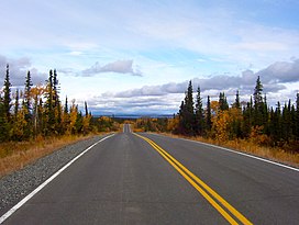
Copper Plateau taiga | |
---|---|
Ecology | |
Realm | Nearctic |
Biome | Boreal forests/taiga |
Borders | |
Geography | |
Area | 17,257 km2 (6,663 sq mi) |
Country | United States |
State | Alaska |
Climate type | Subarctic (Dfc) |
Conservation | |
Conservation status | Relatively stable/intact [1] |
Protected | 5,195 km2 (30%) [2] |
The Copper Plateau taiga is an ecoregion of North America, as defined by the World Wildlife Fund (WWF) categorization system and the Commission for Environmental Cooperation, in the Taiga and Boreal forests, Biome, Alaska.
This ecoregion consists of a large flat plateau in southeastern Alaska at 400-900m above sea level, surrounded by the high mountains and dotted with many lakes and marshes. The area is almost entirely within the Wrangell – St. Elias National Park and Preserve while the Denali Highway crosses the ecoregion in the northwest. This a very wet and damp region with up to 460mm rainfall per year and with temperatures ranging from -27 °C in winter to 21 °C in summer there are patches of shallow permafrost. [1]
To survive here plants have to be adapted to the damp conditions and the dominant tree is black spruce ( Picea mariana ) while the boggier areas have the dwarf birches ( Betula glandulosa and Betula nana ) along with shrubs and sedges such as Eriophorum angustifolium and Carex and herbs such as Menyanthes trifoliata , Petasites frigidus and Comarum palustre . Well-drained areas have communities of white spruce ( Picea glauca ), black cottonwood ( Populus trichocarpa ) and quaking aspen ( Populus tremuloides ).
Lake Louise, Paxson Lake and the many other wetlands of the plain are nesting grounds for may birds including the trumpeter swan, the largest waterfowl in North America. The Copper River is home to salmon especially Chinook salmon and sockeye salmon. Mammals include the Nelchina caribou herd that migrates across the western side of the plain.
Habitat has been lost to development around Glenallen and to logging along the Copper River and on Alaska Native Regional Corporations land near Chitina.
A 2017 assessment found that 5,195 km2, or 30%, of the ecoregion is in protected areas. [2] The eastern portion of the ecoregion is in Wrangell–St. Elias National Park and Preserve.
Yukon is in the northwestern corner of Canada and is bordered by Alaska, British Columbia and the Northwest Territories. The sparsely populated territory abounds with natural scenery, snowmelt lakes and perennial white-capped mountains, including many of Canada's highest mountains. The territory's climate is Arctic in territory north of Old Crow, subarctic in the region, between Whitehorse and Old Crow, and humid continental climate south of Whitehorse and in areas close to the British Columbia border. Most of the territory is boreal forest with tundra being the main vegetation zone only in the extreme north and at high elevations.
The Northern Pacific coastal forests are temperate coniferous forest ecoregion of the Pacific coast of North America. It occupies a narrow coastal zone of Alaska, between the Pacific Ocean and the northernmost Pacific Coast Ranges, covering an area of 23,300 square miles, extending from the Alexander Archipelago in southeast Alaska along the Gulf of Alaska to the western Kenai Peninsula and eastern Kodiak Island. The Pacific Coastal Mountain icefields and tundra ecoregion lies inland, at higher elevations in the Coast Mountains. The ecoregion receives high rainfall, which varies considerably based on exposure and elevation. It contains a quarter of the world's remaining temperate rain forest.
The Cascade Mountains leeward forests are a temperate coniferous forest ecoregion of North America, as defined by the World Wildlife Fund (WWF) categorization system.
The Alberta–British Columbia foothills forests are a temperate coniferous forests ecoregion of Western Canada, as defined by the World Wildlife Fund (WWF) categorization system. This ecoregion borders Canada's taiga and contains a mix of subarctic forest and temperate forest species as a result. This makes the region an ecotone region, or a region that acts as a buffer between two other biomes.
The Alaska Peninsula montane taiga is a taiga and boreal forests ecoregion, located in Alaska, and defined by the World Wildlife Fund (WWF) categorization system.
The Cook Inlet taiga is a taiga and boreal forests ecoregion in Alaska.
The Eastern Canadian Shield taiga is an ecoregion of Canada as defined by the World Wildlife Fund (WWF) categorization system.
The Yukon Interior dry forests is a taiga ecoregion of Canada.
The Muskwa-Slave Lake Taiga ecoregion covers Canadian taiga in northwestern Alberta, northeastern British Columbia and a large portion of the southwestern Northwest Territories around the Mackenzie River valley and the Great Slave Lake.
The interior Alaska–Yukon lowland taiga is an ecoregion in the taiga and boreal forests biome, of far northern North America.
The Mid-Canada Boreal Plains Forests is a taiga ecoregion of Western Canada, designated by One Earth. It was previously defined as the Mid-Continental Canadian Forests by the World Wildlife Fund (WWF) categorization system, before it was modified by One Earth, the successor to WWF.
The Midwest Canadian Shield Forests is an ecoregion in Canada, classified as a Taiga and Boreal Forests Biome.
The Alaska–St. Elias Range tundra is an ecoregion of northwestern North America.
The Central Canadian Shield forests are a taiga ecoregion of Eastern Canada, as defined by the World Wildlife Fund (WWF) categorization system.
The Beringia upland tundra is a mountainous tundra ecoregion of North America, on the west coast of Alaska.
The Western Great Lakes forests is a terrestrial ecoregion as defined by the World Wildlife Fund. It is within the temperate broadleaf and mixed forests biome of North America. It is found in northern areas of the United States' states of Michigan, Wisconsin and Minnesota, and in southern areas of the Canadian province of Manitoba and northwestern areas of the province of Ontario.
Northern Canadian Shield taiga is a taiga ecoregion located in northern Canada, stretching from Great Bear Lake in the Northwest Territories to Hudson Bay in eastern Nunavut. The region supports conifer forests to its northern edge, where the territory grades into tundra. The open forest in this transition zone is characterized by widely scattered, stunted stands of black spruce and tamarack, with some white spruce. The ecoregion lies over the northwestern extent of the Canadian Shield.
The West Siberian broadleaf and mixed forests, also known as the Western Siberian hemiboreal forests, is an ecoregion in Russia. It consists of a thin band of mixed forest along the southernmost edge of the West Siberian taiga in Western Siberia, and north of the forest steppe belt. The biodiversity of the zone is the highest in Siberia, due to its transitional position between many different ecoregions. The area acts as a long corridor for migration of animals along the east-west axis. The ecoregion is in the Palearctic realm, with a Humid Continental climate. It covers 223,516 km2 (86,300 sq mi).
Pacific Coastal Mountain icefields and tundra is a tundra ecoregion in Alaska, British Columbia, and Yukon, as defined by the World Wildlife Fund (WWF) categorization system.
The Northwest Territories taiga ecoregion (WWF:NA0614) is located in the Northwest Territories and Yukon provinces of Canada. It covers forest and tundra along the Mackenzie River Valley and the surrounding highlands in the southern portion of the valley.
{{cite journal}}
: CS1 maint: date and year (link) Supplemental material 2 table S1b.