Denali Highway

Last updated

Alaska 8 shield.svg

Denali Highway

Denali Highway
Denali Highway highlighted in red
Route information
Maintained by Alaska DOT&PF
Length135 mi [1]  (217 km)
Existedc.1953 [2] –present
Major junctions
West endAlaska 3 shield.svg AK-3 (George Parks Highway) in Cantwell
Major intersectionsOld Parks Highway in Cantwell
East endAlaska 4 shield.svg AK-4 (Richardson Highway) in Paxson
Location
Country United States
State Alaska
Boroughs Denali, Matanuska-Susitna, Copper River
Highway system
Alaska 7 shield.svg AK-7 Alaska 9 shield.svg AK-9

Denali Highway (Alaska Route 8) is a lightly traveled, mostly gravel highway in the U.S. state of Alaska. It leads from Paxson on the Richardson Highway to Cantwell on the Parks Highway. Opened in 1957, it was the first road access to Denali National Park. Since 1971, primary park access has been via the Parks Highway, which incorporated a section of the Denali Highway from Cantwell to the present-day park entrance. The Denali Highway is 135 miles (217 km) in length.

Contents

Conditions

The highway is now little used and poorly maintained, and closed to all traffic from October to mid-May each year. [3] Only the easternmost 21.3 miles (34.3 km) and westernmost 2.6 miles (4.2 km) are paved; whether the remainder should be paved as well is a continual source of debate. Washboarding and extreme dust are common, and the recommended speed limit is 30 mph (48 km/h).

Route description

The Denali Highway as seen in summer. Denali Highway.jpg
The Denali Highway as seen in summer.

Traveling west, the Denali Highway leaves the Richardson Highway (Alaska Route 4) at Paxson, and climbs steeply up into the foothills of the central Alaska Range. The first 21 miles (34 km), to Tangle Lakes, are paved. Along its length, the highway passes through three of the principal river drainages in Interior Alaska: the Copper River drainage, the Tanana/Yukon drainage and the Susitna drainage. Along the way, in good weather, there are views of the peaks and glaciers of the central Alaska Range, including Mount Hayes (13,700 ft), Mount Hess (11,940 ft) and Mount Deborah (12,688 ft). At MP 15, from the pullout on the south side of the road, in clear weather it is possible to see the Wrangell Mountains, the Chugach Mountains and the Alaska Range.[ citation needed ]

The first 45 miles (72 km) winds through the Amphitheater Mountains, cresting at Maclaren Summit, at 4,086 feet (1,245 m) the second highest road in Alaska. The road then drops down to the Maclaren River Valley with fine views north to Maclaren Glacier. After crossing the Maclaren River, the road winds through the geologically mysterious Crazy Notch and then along the toe of the Denali Clearwater Mountains to the Susitna River. After crossing the Susitna River the road extends across the glacier's outwash plains to the Nenana River, and then down the Nenana River to Cantwell on the George Parks Highway (Alaska Route 3).

Services

There are developed campgrounds at Tangle Lakes (MP 22) and Brushkana Creek (MP 104), but there are dozens of pullouts where one can camp on public lands.

Services are scant along this road.

Year-round operations include Denali Highway Cabins & Tours (MP 0.2), Maclaren River Lodge (MP 42), Alpine Creek Lodge (MP68), Backwoods Lodge (MP134) and Cantwell Lodge (MP138); summer-only operations include Tangle Lakes Lodge (MP 22), Tangle River Inn (MP 20), Clearwater Mountain Lodge (MP 82). Winter travel on the Denali Highway is exclusively by snowmobile and dogsled. Automobile travelers are severely discouraged from attempting to traverse the road in winter; as recently as 1996 three persons died from exposure when snows blocked their progress. The road is cleared by DOT late in April and generally is passable by non-4WD from then until the first snows close it, usually late September on the eastern, tundra end and late October-early November on the lower, boreal forest western end.

Recreation

White Spruce taiga along the Denali Highway, with the Alaska Mountain Range in the Background Picea glauca taiga.jpg
White Spruce taiga along the Denali Highway, with the Alaska Mountain Range in the Background

The Tangle Lakes constitute the headwaters of the Delta River, a popular destination for canoeists as it is the launch point of the Delta River Canoe Trail. [4]

The Denali Highway is an important birding destination. It offers road access to alpine terrain – not that common in Alaska – and, in the brief birding season there, good viewing of a number of alpine breeders, including Arctic Warbler, Smith's Longspur, Long-tailed Jaeger, Whimbrel, Surfbird, Lapland Longspur, Horned Lark, Short-eared Owl, Wandering Tattler, Gyrfalcon and much more. A walk north along The Bureau of Land Management's (BLM) Maclaren Summit Trail (MP 39) can be very productive. There are also trumpeter swans and various other waterfowl in the lakes and ponds along the route.

Fishing for grayling and lake trout is possible in any of the clear and unglaciated streams.[ citation needed ]

Because the area is hunted heavily, larger mammals are much less common than in Denali National Park, but moose, grizzly bear, and caribou are fairly common. The Nelchina caribou herd, approximately 36,000 animals as of winter 2009–2010, normally passes through this area after calving season ends, and some autumns and winters as many as 16,000 animals can be seen at once. The herd forms an important foodsource for many residents of southcentral Alaska, and visitors eager to view the animals may be competing with hunters. The many lakes along the road are also a destination for duck hunting in the fall.

Most of the land along the highway is publicly owned. There are several BLM-maintained trails, and dozens of informal trails. This is a stretch of wild Alaska that is pretty much unspoiled, relatively accessible and scenic.

Major intersections

BoroughLocationmi [5] kmDestinationsNotes
Denali Cantwell 0.00.0Alaska 3 shield.svg AK-3 (George Parks Highway)Western end of state maintenance; highway continues west to Cantwell Airport via dirt road
0.40.64Old Parks HighwayAccess to Alaska DOT&PF Cantwell Station
Unorganized Paxson 134216Paxson Airport Access RoadAccess to Paxson Airport
135217Alaska 4 shield.svg AK-4 (Richardson Highway)Eastern terminus
1.000 mi = 1.609 km; 1.000 km = 0.621 mi

See also

Related Research Articles

<span class="mw-page-title-main">Interior Alaska</span> Geographic region

Interior Alaska is the central region of Alaska's territory, roughly bounded by the Alaska Range to the south and the Brooks Range to the north. It is largely wilderness. Mountains include Denali in the Alaska Range, the Wrangell Mountains, and the Ray Mountains. The native people of the interior are Alaskan Athabaskans. The largest city in the interior is Fairbanks, Alaska's second-largest city, in the Tanana Valley. Other towns include North Pole, just southeast of Fairbanks, Eagle, Tok, Glennallen, Delta Junction, Nenana, Anderson, Healy and Cantwell. The interior region has an estimated population of 113,154.

<span class="mw-page-title-main">Cantwell, Alaska</span> Census-designated place in Alaska, United States

Cantwell is a census-designated place (CDP) in Denali Borough, Alaska, United States. As of the 2020 census, the population of the CDP was 200.

<span class="mw-page-title-main">Glennallen, Alaska</span> CDP in Alaska, United States

Glennallen is a census-designated place (CDP) in the Copper River Census Area in the Unorganized Borough of the U.S. state of Alaska. As of the 2020 census, the population of the CDP was 439, down from 483 in 2010. It is the most populated community in the census area.

<span class="mw-page-title-main">Nenana, Alaska</span> City in Alaska, United States

Nenana (Lower Tanana: Toghotili; is a home rule city in the Yukon-Koyukuk Census Area of the Unorganized Borough in the Interior of the U.S. state of Alaska. Nenana developed as a Lower Tanana community at the confluence where the tributary Nenana River enters the Tanana. The population was 378 at the 2010 census, down from 402 in 2000.

<span class="mw-page-title-main">Alaska Range</span> North American mountain range

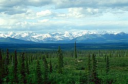
The Alaska Range is a relatively narrow, 600-mile-long (950 km) mountain range in the southcentral region of the U.S. state of Alaska, from Lake Clark at its southwest end to the White River in Canada's Yukon Territory in the southeast. The highest mountain in North America, Denali, is in the Alaska Range. It is part of the American Cordillera.

<span class="mw-page-title-main">Denali National Park and Preserve</span> National park in Alaska, US

Denali National Park and Preserve, formerly known as Mount McKinley National Park, is an American national park and preserve located in Interior Alaska, centered on Denali, the highest mountain in North America. The park and contiguous preserve encompass 6,045,153 acres which is larger than the state of New Hampshire. On December 2, 1980, 2,146,580-acre Denali Wilderness was established within the park. Denali's landscape is a mix of forest at the lowest elevations, including deciduous taiga, with tundra at middle elevations, and glaciers, snow, and bare rock at the highest elevations. The longest glacier is the Kahiltna Glacier. Wintertime activities include dog sledding, cross-country skiing, and snowmobiling. The park received 594,660 recreational visitors in 2018.

<span class="mw-page-title-main">Nenana River</span> River in Alaska, United States

The Nenana River is a tributary of the Tanana River, approximately 140 miles (230 km) long, in central Alaska in the United States. It drains an area on the north slope of the Alaska Range on the south edge of the Tanana Valley southwest of Fairbanks.

The Glenn Highway is a highway in the U.S. state of Alaska, extending 179 miles (288 km) from Anchorage near Merrill Field to Glennallen on the Richardson Highway. The Tok Cut-Off is often considered part of the Glenn Highway, for a total length of 328 miles (528 km).

<span class="mw-page-title-main">George Parks Highway</span> Highway in Alaska

The George Parks Highway, usually called simply the Parks Highway, runs 323 miles (520 km) from the Glenn Highway 35 miles (56 km) north of Anchorage to Fairbanks in the Alaska Interior. The highway, originally known as the Anchorage-Fairbanks Highway, was completed in 1971, and given its current name in 1975.

<span class="mw-page-title-main">Alaska Railroad</span> Alaskan Class II railroad system

The Alaska Railroad is a Class II railroad that operates freight and passenger trains in the state of Alaska. The railroad's mainline is over 470 miles (760 km) long and runs between Seward on the southern coast and Fairbanks, near the center of the state and the Arctic Circle, passing through Anchorage and Denali National Park where 17% of visitors arrive by train. The railroad has about 656 miles (1,056 km) of track, including sidings, rail yards and branch lines, including the branch to Whittier, where the railroad interchanges freight railcars with the contiguous United States via rail barges that sail between the Port of Whittier and Harbor Island in Seattle.

<span class="mw-page-title-main">Edgerton Highway</span>

The Edgerton Highway is a minor highway in the U.S. state of Alaska that extends 33 miles (53 km) from the Richardson Highway near Copper Center to the town of Chitina. The McCarthy Road, within the Wrangell-Saint Elias National Park and Preserve, is a 58-mile (93 km) extension from Chitina to McCarthy.

<span class="mw-page-title-main">Iditarod Trail</span> Long-distance trail

The Iditarod Trail, also known historically as the Seward-to-Nome Trail, is a thousand-plus mile (1,600 km) historic and contemporary trail system in the US state of Alaska. The trail began as a composite of trails established by Alaskan native peoples. Its route crossed several mountain ranges and valleys and passed through numerous historical settlements en route from Seward to Nome. The discovery of gold around Nome brought thousands of people over this route beginning in 1908. Roadhouses for people and dog barns sprang up every 20 or so miles. By 1918 World War I and the lack of 'gold fever' resulted in far less travel. The trail might have been forgotten except for the 1925 diphtheria outbreak in Nome. In one of the final great feats of dog sleds, twenty drivers and teams carried the life-saving serum 674 miles (1,085 km) in 127 hours. Today, the Iditarod Trail Sled Dog Race serves to commemorate the part the trail and its dog sleds played in the development of Alaska, and the route and a series of connecting trails have been designated Iditarod National Historic Trail.

<span class="mw-page-title-main">Gulkana River</span> River in Alaska, United States

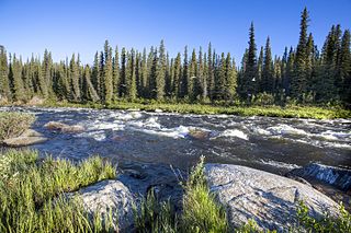
The Gulkana River is a 60-mile (97 km) tributary of the Copper River in the U.S. state of Alaska. Beginning near the southeastern end of Summit Lake in the Alaska Range, the river flows generally south to meet the larger river 9 miles (14 km) northeast of Glennallen. The Richardson Highway and the Trans-Alaska Pipeline run north–south, nearby and roughly parallel to the Gulkana River. Slightly south of Summit Lake the river passes under the east–west Denali Highway near its junction with the Richardson Highway at Paxson.

<span class="mw-page-title-main">Denali State Park</span> State park in Alaska, United States

Denali State Park is a 325,240-acre (131,620 ha) state park in the U.S. state of Alaska. It is located in the Matanuska-Susitna Borough adjacent to the east side of Denali National Park and Preserve, along the Parks Highway.

The Stampede Trail is a remote road and trail located in the Denali Borough in the U.S. state of Alaska. Apart from a paved or maintained gravel road for 8 miles (13 km) between Eight Mile Lake and the trail's eastern end, the route consists of a primitive and at times dangerous hiking or ATV trail following the path of the original road, which has deteriorated over the years. The route ends at an abandoned antimony mine at 63.740739°N 150.379229°W along Stampede Creek, a couple miles past Stampede Airport's grass airstrip.

<span class="mw-page-title-main">Alaska Route 1</span> Highway in Alaska

Alaska Route 1 (AK-1) is a state highway in the southern part of the U.S. state of Alaska. It runs from Homer northeast and east to Tok by way of Anchorage. It is one of two routes in Alaska to contain significant portions of freeway: the Seward Highway in south Anchorage and the Glenn Highway between Anchorage and Palmer.

The Teklanika River is a 91-mile (146 km) tributary of the Nenana River in the U.S. state of Alaska. The Nenana is a tributary of the Tanana River, which is part of the Yukon River drainage in the central interior region of the state. Flowing northward from headwaters at the Cantwell Glacier in the Alaska Range, the Teklanika drains an area widely visited by tourists to Denali National Park and Preserve. The park's only road crosses the river at milepost 31 and a National Park campground is located on its eastern bank at milepost 29.

<span class="mw-page-title-main">2002 Denali earthquake</span> 7.9 magnitude; November 3, 2002

The 2002 Denali earthquake occurred at 22:12:41 UTC November 3 with an epicenter 66 km ESE of Denali National Park, Alaska, United States. This 7.9 Mw earthquake was the largest recorded in the United States in 37 years. The shock was the strongest ever recorded in the interior of Alaska. Due to the remote location, there were no fatalities and only one injury.

<span class="mw-page-title-main">Tangle Lakes</span> Archaeological site in Alaska, United States

The Tangle Lakes are a 16-mile (26 km) long chain of lakes connected by streams in interior Alaska. They form the headwaters for the Delta River.

References

  1. Alaska Department. "Denali Highway". Bureau of Land Management. Archived from the original on April 14, 2012. Retrieved April 20, 2012.
  2. Staff. "History Time Line For Denali National Park & Preserve" (PDF). National Park Service. Archived from the original (PDF) on September 1, 2009. Retrieved April 20, 2012.
  3. Whitfield, p. 399
  4. Staff (2007). The Milepost (59th ed.). Augusta, GA: Morris Communications. p. 497. ISBN   978-1-892154-21-7.
  5. Google (April 20, 2012). "Overview Map of Denali Highway (AK-8)" (Map). Google Maps . Google. Retrieved April 20, 2012.

Further reading

Route map:

Template:Attached KML/Denali Highway
KML is from Wikidata