Cartography is the study and practice of making and using maps. Combining science, aesthetics and technique, cartography builds on the premise that reality can be modeled in ways that communicate spatial information effectively.

The Society of Antiquaries of London (SAL) is a learned society "charged by its Royal Charter of 1751 with 'the encouragement, advancement and furtherance of the study and knowledge of the antiquities and history of this and other countries'." It is based at Burlington House, Piccadilly, London, and is a registered charity.

The Laguna Copperplate Inscription is an official acquittance certificate inscribed onto a copper plate in the Shaka year 822. It is the earliest known calendar-dated document found within the Philippine Islands.

Wood engraving is a printmaking technique, in which an artist works an image into a block of wood. Functionally a variety of woodcut, it uses relief printing, where the artist applies ink to the face of the block and prints using relatively low pressure. By contrast, ordinary engraving, like etching, uses a metal plate for the matrix, and is printed by the intaglio method, where the ink fills the valleys, the removed areas. As a result, the blocks for wood engravings deteriorate less quickly than the copper plates of engravings, and have a distinctive white-on-black character.

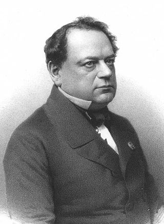
Ralph Agas was an English land surveyor and cartographer. He was born at Stoke-by-Nayland, Suffolk, in about 1540, and lived there throughout his life, although he travelled regularly to London. He began to practise as a surveyor in about 1566, and has been described as "one of the leaders of the emerging body of skilled land surveyors".
Electrotyping is a chemical method for forming metal parts that exactly reproduce a model. The method was invented by Moritz von Jacobi in Russia in 1838, and was immediately adopted for applications in printing and several other fields. As described in an 1890 treatise, electrotyping produces "an exact facsimile of any object having an irregular surface, whether it be an engraved steel- or copper-plate, a wood-cut, or a form of set-up type, to be used for printing; or a medal, medallion, statue, bust, or even a natural object, for art purposes."

Steel engraving is a technique for printing illustrations based on steel instead of copper. It has been rarely used in artistic printmaking, although it was much used for reproductions in the 19th century. Steel engraving was introduced in 1792 by Jacob Perkins (1766–1849), an American inventor, for banknote printing. When Perkins moved to London in 1818, the technique was adapted in 1820 by Charles Warren and especially by Charles Heath (1785–1848) for Thomas Campbell's Pleasures of Hope, which contained the first published plates engraved on steel. The new technique only partially replaced the other commercial techniques of that time such as wood engraving, copper engraving and later lithography.
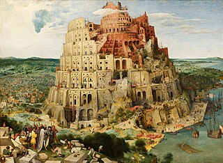
The Tower of Babel was the subject of three paintings by Pieter Bruegel the Elder. The first, a miniature painted on ivory, was painted while Bruegel was in Rome and is now lost. The two surviving paintings, often distinguished by the prefix "Great" and "Little", are in the Kunsthistorisches Museum, Vienna and the Museum Boijmans Van Beuningen in Rotterdam respectively. Both are oil paintings on wood panels.

Lucas van Valckenborch or Lucas van Valckenborch the Elder was a Flemish painter, mainly known for his landscapes. He also made contributions to portrait painting, and allegorical and market scenes. Court painter to Archduke Matthias, the governor of the Spanish Netherlands in Brussels, he later migrated to Austria and then Germany where he joined members of his extended family of artists who had moved there for religious reasons.

Roller printing, also called cylinder printing or machine printing, on fabrics is a textile printing process patented by Thomas Bell of Scotland in 1783 in an attempt to reduce the cost of the earlier copperplate printing. This method was used in Lancashire fabric mills to produce cotton dress fabrics from the 1790s, most often reproducing small monochrome patterns characterized by striped motifs and tiny dotted patterns called "machine grounds".

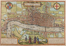
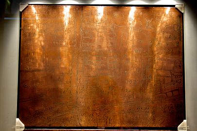
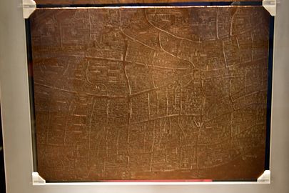
The "Woodcut" map of London, formally titled Civitas Londinum, and often referred to as the "Agas" map of London, is one of the earliest true maps of the City of London and its environs. The original map probably dated from the early 1560s, but it survives only in later and slightly modified copies. It was printed from woodcut blocks on eight sheets, and in its present state measures approximately 2 feet 4 inches (71 cm) high by 6 feet (180 cm) wide. There has been some damage to the blocks, and it was probably originally fractionally larger.
William Hole was a skilled English engraver who died in 1624 though the date of his birth is uncertain. Hole's work suggests French influence.
George Lily was an English Roman Catholic priest, humanist scholar, biographer, topographer and cartographer.

Hendrick van Cleve or Hendrik van Cleve III was a Flemish painter, draughtsman and designer of prints. He is known for topographical views, including views of Rome and the Vatican, as well as imaginary landscapes. Traditionally, a large number of depictions of the construction of the Tower of Babel have been attributed to him but most of these are now attributed to anonymous Flemish painters, who are referred to as 'The Hendrik van Cleve III Group'.

Marten van Valckenborch or Marten van Valckenborch the Elder, was a Flemish Renaissance painter, mainly known for his landscapes and city scapes. He also made allegorical paintings and some portraits. After commencing his career in the Spanish Netherlands, he later migrated to Frankfurt in Germany where he and other members of his extended family of artists played an important role in local artistic developments.
The Visscher panorama is an engraving by Claes Visscher (1586-1652) depicting a panorama of London. It shows an imagined view of London in around 1600. The engraving was first published in Amsterdam in 1616, with the title "Londinum Florentissima Britanniae Urbs Toto Orbe Celeberrimum Emporiumque".
Henry Ninham was an English landscape artist, engraver and heraldic painter. He and his father John Ninham belonged to the Norwich School of painters, a group of artists who all worked or lived in Norwich during all or part of their working lives from around 1800 to 1880. Along with the Norwich School artists John Thirtle and David Hodgson, he was the foremost recorder of Norwich's architectural heritage prior to the invention of photography.
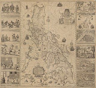
Carta Hydrographica y Chorographica de las Islas Filipinas, more commonly known as the Velarde map, is a map of the Philippines made and first published in Manila in 1734 by the Jesuit cartographer Pedro Murillo Velarde, the engraver Nicolás de la Cruz Bagay, and the artist Francisco Suárez. The World Digital Library describes it as the "first and most important scientific map of the Philippines". It is frequently referred to as the "Mother of all Philippine Maps".

A New and Universal History, Description and Survey of the Cities of London and Westminster, the Borough of Southwark, and their Adjacent Parts... by Walter Harrison is a 1775 book illustrated with 102 monochrome plates, describing the appearance of London at that time. It was published by John Cooke in 70 parts. These were issued weekly, each with one or two of the plates. The illustrations were prints made using engraved copper plates.
Cornelius Tiebout (1773?-1832) was an American copperplate engraver. According to the Library of Congress and many followers, Tiebout was born about 1773. If so, his earliest known engraving was published while he was about fifteen years old.