This article needs additional citations for verification .(December 2013) |

Coppet Hill or Coppett Hill is a local nature reserve in the parish of Goodrich near Ross-on-Wye in Herefordshire. [1] [2]
This article needs additional citations for verification .(December 2013) |
Coppet Hill or Coppett Hill is a local nature reserve in the parish of Goodrich near Ross-on-Wye in Herefordshire. [1] [2]
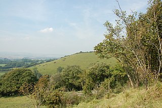
It earned local nature reserve status in 2000 after 15 years of conservation management. It is owned by Trustees who live in the parish and conservation work is supported by the Friends of Coppett Hill. It is a mix of woodland and open hillside and a good site for butterflies, deer, birdlife and fungi.
Permissive paths give access to the reserve as well as offering views stretching from the Brecon Beacons and Black Mountains to the Clee Hills in Shropshire and the Malvern Hills in Worcestershire. The reserve is within the Wye Valley Area of Outstanding Natural Beauty.
Coppett Hill is easily accessed from the A40 between Ross-on-Wye and Monmouth. There is no parking on Coppett Hill and access is on foot only
There are many other walks around the area. Coppett Hill is skirted by the Wye Valley Walk.
Sometimes referred to as Lydbrook Tunnel. It opened in 1873, along with the Ross and Monmouth Railway, allowing passage from Lydbrook Junction to Kerne Bridge.


The River Wye is the fourth-longest river in the UK, stretching some 250 kilometres from its source on Plynlimon in mid Wales to the Severn estuary. For much of its length the river forms part of the border between England and Wales. The Wye Valley is designated an Area of Outstanding Natural Beauty. The Wye is important for nature conservation and recreation, but is affected by pollution.

Goodrich is a village in south Herefordshire, England close to Gloucestershire and the Forest of Dean, situated near the River Wye at grid reference SO574193. It is known for its Norman and mediaeval castle built with Old Red Sandstone.
The Gloucestershire Wildlife Trust is the Gloucestershire local partner in a conservation network of 46 Wildlife Trusts. The Wildlife Trusts are local charities with the specific aim of protecting the United Kingdom's natural heritage. The Gloucestershire Wildlife Trust is managed by a board of trustees elected from its membership who provide overall direction for the development of the trust and there are advisory committees. The work of the trust is carried out through staff and volunteers.
The London Borough of Barnet, located on the northern periphery of London and having much of the area within its boundaries in the Metropolitan Green Belt, has many parks and open spaces. In addition there are large areas taken over by cemeteries and golf courses, and part of Hampstead Heath.

The Wye Valley Area of Outstanding Natural Beauty is an internationally important protected landscape straddling the border between England and Wales.

Lydbrook is a civil parish in the Forest of Dean, a local government district in the English county of Gloucestershire and is located in the Wye Valley. It is on the north west edge of the Forest of Dean's present legal boundary proper. It comprises the districts of Lower Lydbrook, Upper Lydbrook, Joys Green and Worrall Hill. It has a mile and a half long high street, reputed to be the longest high street of any village in England.
Wye and Crundale Downs is a 358.3-hectare (885-acre) biological and geological Site of Special Scientific Interest in a number of separate areas east of Ashford in Kent. It is a Special Area of Conservation and a Nature Conservation Review site, Grade I. and it is part of Kent Downs Area of Outstanding Natural Beauty. Some areas are part of a National Nature Reserve, and another area is listed on the Geological Conservation Review.

The Lower Lydbrook Viaduct was an iron railway viaduct with stone piers, it was on the Severn and Wye Railway and situated in Lower Lydbrook, Gloucestershire, England.

Lady Park Wood National Nature Reserve is a 45-hectare (110-acre) nature reserve straddling the borders of Gloucestershire in England and Monmouthshire in Wales. Most of the wood is in Wales – where it forms Wales' easternmost point – but it is managed under agreement with Natural England.

Monmouth Troy was one of the two former railway stations at Monmouth. It was built in 1857 by the Coleford, Monmouth, Usk and Pontypool Railway and was used by several other branch lines as the local rail network expanded. The station closed in January 1964 following the closure of the last two lines to the station, the Wye Valley Railway and the Ross and Monmouth Railway.

The Ross and Monmouth Railway was a standard gauge railway of 13 miles (21 km) which ran between Ross-on-Wye, in Herefordshire, England and Monmouth, Wales.
Lydbrook Junction railway station is a disused railway station in England opened by the Ross and Monmouth Railway in 1873, it remained open for 91 years until 1964 when the line finally closed to freight, though passenger services ceased in 1959. The station was constructed in the hamlet of Stowfield approximately half a mile from Lydbrook and its viaduct on the Severn and Wye Railway. It was located approximately 4 miles and 34 chains along the railway from Ross-on-Wye station. In 1874 the Severn and Wye Railway opened a branch from Serridge Junction and Cinderford, passenger services commenced in 1875. All passenger trains along the S&W branch were withdrawn from 1929.

Coppetts Wood and Scrublands is a 14.5-hectare (36-acre) Site of Borough Importance for Nature Conservation, Grade I, between Muswell Hill and Friern Barnet in the London Borough of Barnet. It is part of the Coppetts Wood and Glebelands Local Nature Reserve.

Glebelands is Site of Borough Importance for Nature Conservation, Grade I, in Colney Hatch in the London Borough of Barnet. It is also part of the Coppett's Wood and Glebelands Local Nature Reserve.

Upper Wye Gorge is a Site of Special Scientific Interest (SSSI), noted for its biological and geological characteristics, around Symonds Yat in the Wye Valley on the Wales–England border. The site is listed in the 'Forest of Dean Local Plan Review' as a Key Wildlife Site (KWS).

Rose Walk is a 2.7 hectare Local Nature Reserve in Berrylands in the Royal Borough of Kingston upon Thames in London. It is also part of the Hogsmill Valley Site of Borough Importance for Nature Conservation, Grade 1.

Kerne Bridge was built over the River Wye in the County of Herefordshire, England in 1825–28, on the site of an ancient ford crossing known as Flanesford. It is designated as a Scheduled Monument. Carrying the B4229 road, it connects the parishes of Walford on the river's left bank and Goodrich on the right. It is situated in the heart of the Wye Valley Area of Outstanding Natural Beauty and marks the northern end of the Upper Wye Gorge.
Lower Lydbrook railway station served the civil parish of Lydbrook, Gloucestershire, England, from 1875 to 1903 on the Severn and Wye Railway.
51°51′29″N2°37′12″W / 51.858°N 2.620°W
| | This Herefordshire location article is a stub. You can help Wikipedia by expanding it. |