Cordal

Last updated
Cordal
Village
Castles of Munster, Kilmurry, Kerry - revisited (7) - geograph.org.uk - 6277288.jpg
Kilmurry Castle, north of Cordal village, comprises a 16th century tower house and 17th century fortified house addition
Ireland adm location map.svg
Red pog.svg
Cordal
Location in Ireland
Coordinates: 52°13′05″N9°23′06″W / 52.2181°N 9.3851°W / 52.2181; -9.3851
Country Ireland
Province Munster
County County Kerry
Irish grid reference R053082

Cordal (Irish : Cordal) is a village and electoral division in County Kerry, Ireland. [1] The townlands of Cordal East and Cordal West are in the civil parish of Ballincuslane and the historical barony of Trughanacmy. [2] [3] As of the 2011 census, Cordal East and Cordal West had populations of 115 and 117 residents respectively. [4]

Contents

Built heritage

Evidence of ancient settlement in Cordal East and Cordal West townlands include a number of ring fort, fulacht fiadh, holy well, ecclesiastical enclosure and standing stone sites. [5] [6] [7]

The ruins of Kilmurry Castle, in Kilmurry townland approximately 1 mile (1.6 km) north of Cordal village, include a 16th century tower house and a later 17th century fortified house addition. [8] This castle reputedly gives its name to Ballincuslane parish (Baile an Chaisleáin meaning 'town[land] of the castle'). [9] [10]

The local Catholic church (opened 1872) and Church of Ireland church (built c.1850) are both in Cordal West. [11] [12] The Catholic church, the Church of the Immaculate Conception, is one of three churches in the ecclesiastical parish of Castleisland in the Diocese of Kerry. [13]

Amenities and sport

There is an An Post post office [14] and a public house in the village. [15] The local national (primary) school, Kilmurry National School or Scoil Mhuire, is in Kilmurry townland and had approximately 100 pupils enrolled as of late 2019. [16] The area is served by some limited TFI Local Link bus routes. [17]

The local Gaelic Athletic Association (GAA) club, Cordal GAA, [18] won the East Kerry intermediate football championship in 2023. [19]

Related Research Articles

<span class="mw-page-title-main">Kinvara</span> Village in south County Galway, Ireland

Kinvara or Kinvarra is a sea port village in the southwest of County Galway, Ireland. It is located in the civil parish of Kinvarradoorus in the north of the barony of Kiltartan. Kinvarra is also an electoral division.

<span class="mw-page-title-main">Oranmore</span> Town in County Galway, Ireland

Oranmore is a town in County Galway, Ireland, 9 km (5.6 mi) east of Galway city on an inlet of Galway Bay. At the 2022 census, Oranmore had a population of 5,819.

<span class="mw-page-title-main">Ballybunion</span> Seaside resort in County Kerry, Ireland

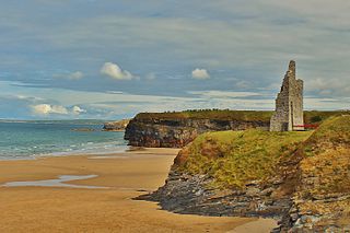
Ballybunion or Ballybunnion is a coastal town and seaside resort in County Kerry, Ireland, on the Wild Atlantic Way, 15 km (9 mi) from the town of Listowel. As of the 2022 census, Ballybunion had a population of 1,618.

<span class="mw-page-title-main">Kanturk</span> Town in County Cork, Ireland

Kanturk is a town in the north west of County Cork, Ireland. It is situated at the confluence of the Allua (Allow) and Dallow (Dalua) rivers, which stream further on as tributaries to the River Blackwater. It is about 50 kilometres from Cork and Limerick, and lies just north of the main N72 road, 15 km from Mallow and about 40 km from Killarney. Kanturk is within the Cork North-West Dáil constituency.

<span class="mw-page-title-main">Furbo, County Galway</span> Village in County Galway, Ireland

Furbo or Furbogh is a settlement in Connemara, County Galway, Ireland. As of the 2022 census, it had a population of 868 people. It lies along the coast, overlooking Galway Bay, in a Gaeltacht area.

<span class="mw-page-title-main">Meelick, County Clare</span> Village near Limerick city, Ireland

Meelick is a small village and townland in County Clare, Ireland, situated a few kilometres north of Limerick city in the Mid-West Region.

<span class="mw-page-title-main">Rhode, County Offaly</span> Village in County Offaly, Ireland

Rhode is a village in County Offaly, Ireland. It is situated on the R400 at its junction with the R441 which leads to Edenderry, 12 km to the east. Rhode village is on an "island" of high ground surrounded by an expanse of raised bog which forms part of the Bog of Allen.

<span class="mw-page-title-main">Tallow, County Waterford</span> Town in County Waterford, Ireland

Tallow is a town, civil parish and townland in County Waterford, Ireland. Tallow is in the province of Munster near the border between County Cork and County Waterford and situated on a small hill just south of the River Bride.

Currow is a rural village in County Kerry in south west Ireland, located approximately 12 km from Killarney and 18 km from Tralee. Currow is situated on the Brown Flesk River, a tributary of the River Maine.

Staplestown is a village and townland in north County Kildare, Ireland, located 40 kilometres west of Dublin. The village has a church, a school and is home to St Kevin's GAA. The local national (primary) school is Scoil Naomh Mhuire National School.

<span class="mw-page-title-main">Sandpit, County Louth</span> Village in County Louth, Ireland

Sandpit is a small village in the rural hinterland of Drogheda in County Louth, Ireland. It lies in the townland of Milltown, which had a population of 213 as of the 2011 census.

<span class="mw-page-title-main">Scartaglen</span> Village in County Kerry, Ireland

Scartaglen or Scartaglin is a village and townland in the Sliabh Luachra area of County Kerry, Ireland. It is located on the R577 regional road, close to the town of Castleisland. As of the 2011 census, the townland of Scartaglin had a population of 163 people.

<span class="mw-page-title-main">Firies</span> Village in Munster, Ireland

Firies is a village in County Kerry, Ireland in the historical barony of Magunihy. It is situated midway between the hub towns of Killarney (14.5 km), Tralee (16 km), Castleisland (16 km) and Killorglin (13 km). It is on the R561 road between Farranfore and Castlemaine. The population at the 2016 census was 558. There are two principal rivers, namely the Maine and its chief tributary, the Brown Flesk.

<span class="mw-page-title-main">Kilmurry-Negaul</span> Village in County Clare, Ireland

Kilmurry-Negaul is a civil parish and a village in County Clare, Ireland.

<span class="mw-page-title-main">Robinstown, County Meath</span> Village in County Meath, Ireland

Robinstown, in the townland of Balbradagh, is a village in County Meath, Ireland.

Ballyhahill is a village and townland in County Limerick, Ireland. As of the 2016 census, the village had a population of 146 people. It is 40 km west of Limerick city. The White River flows to the east of the village.

<span class="mw-page-title-main">Gleneely</span> Village in County Donegal, Ireland

Gleneely is a village and census town on the Inishowen peninsula in the north of County Donegal in Ulster, Ireland. As of the 2016 census, the village had a population of 236 people.

Ballyhogue or Ballyhoge is a village and census town in County Wexford, Ireland. The village, which lies in a townland and civil parish of the same name, had a population of 255 people as of the 2022 census. It is 10 km south of Enniscorthy.

<span class="mw-page-title-main">Kiltallagh</span> Civil parish in Munster, Ireland

Kiltallagh, sometimes known as Kiltalla, is a civil parish in the historical barony of Trughanacmy in County Kerry, Ireland. Castlemaine is the largest settlement in the civil parish.

<span class="mw-page-title-main">Knockainey</span> Civil parish in County Limerick, Ireland

Knockainey or Knockainy is a civil parish and village in County Limerick, Ireland. It is in the historical barony of Smallcounty, between the towns of Hospital and Bruff.

References

  1. "Cordal". logainm.ie. Placenames Database of Ireland. Retrieved 5 April 2024.
  2. "Cordal East Townland, Co. Kerry". townlands.ie. Retrieved 5 April 2024.
  3. "Cordal West Townland, Co. Kerry". townlands.ie. Retrieved 5 April 2024.
  4. "CD156 - Kerry Population by Private Households, Occupied and Vacancy Rate". data.gov.ie. Central Statistics Office. Retrieved 5 April 2024.
  5. Record of Monuments and Places - County Kerry. Dublin: National Monuments and Historic Properties Service. 1998.
  6. Byrne, Elizabeth; McQueen, Alison; Cronin, Rhoda, eds. (2009). Archaeological inventory of County Kerry. Archaeological Survey of Ireland. Department of the Environment, Heritage and Local Government. ISBN   9780755776238. OCLC   436259331.
  7. Hanbidge, Robert, ed. (July 2011). "Archaeological Survey of Kilnanima, Cordal, County Kerry (Cordal East)" (PDF). Kerry County Council. Retrieved 5 April 2024.
  8. Barrington, T. J. (1976). Discovering Kerry: Its History, Heritage & Topography. Blackwater. p. 230. ISBN   9780905471006. less than a mile further on, in a field on the right, is [..] Kilmurry Castle [..] a 16th century tower house to which was added a now much ruined fortified house of the early part of the 17th century
  9. O'Donovan, John (1841), "Ordnance Survey of Ireland: Letters, Kerry" (PDF), Ordnance Survey Letters, p. 603 (14 C 30 / 28)
  10. Salter, Mike (2004). The Castles of South Munster. Folly Publications. p. 104. ISBN   9781871731668.
  11. "Catholic Church of the Immaculate Conception, Cordal West, Cordal, Kerry". buildingsofireland.ie. National Inventory of Architectural Heritage . Retrieved 5 April 2024.
  12. "Cordal Church (Ballincuslane), Cordal West, Cordal, Kerry". buildingsofireland.ie. National Inventory of Architectural Heritage . Retrieved 5 April 2024.
  13. "Parish - Castleisland". dioceseofkerry.ie. Roman Catholic Diocese of Kerry . Retrieved 5 April 2024.
  14. "Store Locator - Cordal Post Office, Cordal West, Castleisland, Co. Kerry". An Post . Retrieved 5 April 2024.
  15. "Flow goes into reverse as Cordal opens its first pub". The Kerryman. 17 March 2005. Retrieved 5 April 2024.
  16. "Scoil Mhuire B&C, Cordal, Castleisland, Co. Kerry (10394G)" (PDF). gov.ie. Department of Education. 4 December 2019. Retrieved 5 April 2024. Scoil Mhuire B&C is a Catholic, mainstream school situated in the townland of Kilmurry, Cordal [..] There are a hundred pupils enrolled in the school
  17. "Cordal". locallinkkerry.ie. Transport for Ireland . Retrieved 5 April 2024.
  18. "Board: East Kerry Committee - Cordal / Cul". Kerry GAA . Retrieved 5 April 2024.
  19. "Cordal win East Kerry IFC final thanks to Sean Óg Ó Ciárdubhain's brilliant long and late winning free". The Kerryman . 6 November 2023. Retrieved 5 April 2024.