Corduroy Road Remains

Last updated

Corduroy Road Remains
Corduroy Road Remains, Laidley (2009).jpg
Corduroy Road Remains, Laidley, 2009
LocationToowoomba-Ipswich Road, Laidley, Lockyer Valley Region, Queensland, Australia
Coordinates 27°38′48″S152°22′38″E / 27.6466°S 152.3773°E / -27.6466; 152.3773 Coordinates: 27°38′48″S152°22′38″E / 27.6466°S 152.3773°E / -27.6466; 152.3773
Official nameCorduroy Road Remains, Laidley
Typestate heritage (archaeological)
Designated21 October 1992
Reference no.600657
Significant period1850s, 1860s (fabric)
Australia Queensland location map.svg
Red pog.svg
Location of Corduroy Road Remains in Queensland
Australia location map.svg
Red pog.svg
Corduroy Road Remains (Australia)

Corduroy Road Remains is a heritage-listed archaeological site at Toowoomba-Ipswich Road, Laidley, Lockyer Valley Region, Queensland, Australia. The site contains the remnants of the former main dray road between Ipswich and Drayton, which had been upgraded from a track to a corduroy (sand-covered log) road between the 1850s and 1860s, using grey ironbark logs (Eucalyptus drepanophylla).

Contents

The road improved access to the Darling Downs, and was one of a number of works during that era aimed at creating a more trafficable route to the area. However, complaints about poor road conditions continued until the roads were sealed decades later. The remnants are buried below 100–200 millimetres (3.9–7.9 in) of soil, which has limited attempts to assess the condition or surviving length of the road. In the 1970s, the former Shire of Laidley proposed having the road surveyed and researched with a view to exposing a small section for public viewing; however, no action was taken. The site was added to the Queensland Heritage Register on 21 October 1992. [1]

History

In the 19th century, the road between Ipswich and Drayton was one of the main roads of the Moreton Bay district. It was established in the 1840s as a bridle track between head stations, but soon became the principal route for wool drays and supplies, and by 1852 was listed by the New South Wales government as the only first-class road in the Moreton Bay area. Just four years earlier, however, it was described as being in a "wretched condition' and by 1859 very little had changed with the Darling Downs Gazette pointing out that "the road of Christian in Bunyan's Pilgrim's Progress was a bowling green" in comparison to the Ipswich to Drayton route. This was not a unique circumstance, with Queensland road networks in general described as "always bad and often impassable" in the Statistical Register of 1860. With a constant lack of money and a decentralized system of road administration it would be some time before conditions improved. Road construction was expensive and labour-intensive with no local authority to pay for or facilitate road building. [1]

As settlement spread, the development and maintenance of roads became essential for a burgeoning rural economy. During the 1850s efforts were made to improve the passage to the Darling Downs. At Laidley Creek the banks were graded and a low wooden bridge was erected in 1850 at the instigation of the Downs squatters. The following year, the Colonial government spent £ 300 in the Moreton Bay district, including £ 170 on road improvements on the Darling Downs route. In 1854, Phillip D. Vigors was appointed by the New South Wales government as Surveyor of Moreton Bay Roads and instructed to oversee the construction of a trafficable road from Brisbane through Ipswich to Drayton. The work was painstakingly slow and when Vigors resigned in 1856 he reported 'there is abundant work for the next year at least for two surveyors to do nothing but survey and mark the roads in the district". More money was injected into road development in the Laidley area in May 1857 when the Brisbane Board of Works allocated £ 500 to build a bridge over Laidley Creek - a project completed 6 years later. It seems most likely that it was during this period of development in the 1850s and 1860s that the corduroy road was constructed. [1]

The practice of building corduroy roads was common in Europe by the 18th century and was also a common form of construction in America during the post-colonial period. It involved overlapping full or half rounds of logs together transversely and was used in swampy areas as a cheap and simple method of stabilizing road foundations. With the scarcity of labour and financial resources in colonial Queensland, corduroy roads became an important and viable means of dealing with poor road conditions. Moreover, their simple method of construction meant that the employment of an engineer was not required as was the case with the more advanced and more expensive practice of building plank roads, as delineated in 1852 by Captain Payne, a former Royal Engineer, and as tabled in the New South Wales Legislative Council the following year. [1]

In the Laidley region, bad road conditions remained a continuing problem until surfaced roads were laid. In 1893 a report in The Queensland Times outlined the frustration of Laidley farmers who "were prevented from conveying [their crops] ... to market on account of the heavy and boggy nature of the roads, caused by the excessive rainfalls". As early as 1859 the area where the remains of the corduroy road are located was described by a surveyor as "lightly inundated" owing to its flatness. With a plentiful supply of gum and ironbark nearby, it was an ideal and necessary location for a corduroy road. [1]

While corduroy roads were an effective means of traversing a quagmire, they were far from perfect. With rudimentary suspension systems in coaches of the day, travellers found corduroy sections to be far from comfortable. They were also subject to the kind of disrepair that made travel more precarious, as Nehemiah Bartley noted in his reminiscences of his business trips of 1854-55 to the Darling Downs in Opals and Agates: "The next day I had to tackle the scrub on the 'Spicer's Peak' Gap. This road ... had been at one time paved with thick pine logs - a 'corduroy' road, in fact - and, while it lasted, all was well. But, the place was naturally almost a bottomless morass, full of springs; the logs had rotted in the middle, and the sound ends titled up in all directions; a lovely chevaux de frise. It was an awful place for horse, bullock, or vehicle of any kind, to face, the tilted logs adding to the pitfalls of the boggy ground". [1]

While the corduroy road at Laidley remains unexposed it is not possible to determine the condition in which it now exists. A proposal to have the road surveyed and researched with a view to exposing a small section for public viewing was discussed by the Laidley Shire Council in the 1970s, but to date no further action has been taken. [1]

Description

The corduroy road remnants are located on the Old Toowoomba Road between Head Road and Mulgowie Road, 1 kilometre (0.62 mi) southwest of Laidley. While the exact extent of the corduroy road cannot be determined, it is possible that it originally extended across current freehold properties adjacent to the Old Toowoomba Road. [1]

Corduroy roads in general were constructed by overlapping full or half rounds of logs transversely and commonly used in swampy areas to stabilize road foundations. Gravel was sometimes used to seal the surface and due to the surrounding conditions corduroy roads were often covered by mud. The corduroy road at Laidley remains buried below 100–200 millimetres (3.9–7.9 in) of soil, making an assessment of its current physical condition impossible. In 1976, a section of wood from this road was forwarded to the Department of Forestry for investigation. It was revealed that the logs used were grey ironbark (Eucalyptus drepanophylla), a species in plentiful supply nearby, and that some deterioration of the wood had occurred owing to wet rot and termite attack. [1]

Heritage listing

The Corduroy Road remains at Laidley was listed on the Queensland Heritage Register on 21 October 1992 having satisfied the following criteria. [1]

The place is important in demonstrating the evolution or pattern of Queensland's history.

The place is important in demonstrating the evolution or pattern of Queensland's history insofar as it provides evidence of the earliest development of road networks in the Moreton Bay district during the 19th century and the means used by early settlers to cope with the poor condition of roads during this period. With the growth of the Darling Downs from the 1850s onwards there was a necessity to improve communication between communities and market access for farmers. The corduroy road is an example of the practical and inexpensive method employed to ameliorate road conditions in a period when funding for road improvements in the northern districts of New South Wales was limited to occasional government votes. [1]

The place demonstrates rare, uncommon or endangered aspects of Queensland's cultural heritage.

The corduroy road demonstrates rare, uncommon or endangered aspects of Queensland's cultural heritage and is important in demonstrating the principal characteristics of a particular class of cultural places, being a representative example of a once common technique of road building which did not require specific engineering skills and was readily employed by local farmers and residents to overcome difficult conditions along supply and communication routes. [1]

The place is important in demonstrating the principal characteristics of a particular class of cultural places.

The corduroy road demonstrates rare, uncommon or endangered aspects of Queensland's cultural heritage and is important in demonstrating the principal characteristics of a particular class of cultural places, being a representative example of a once common technique of road building which did not require specific engineering skills and was readily employed by local farmers and residents to overcome difficult conditions along supply and communication routes. [1]

Related Research Articles

Laidley, Queensland Town in Queensland, Australia

Laidley is a rural town and locality in the Lockyer Valley Region, Queensland, Australia. In the 2016 census, the locality of Laidley had a population of 3,808 people.

Arthur Sidney Lyon (1817–1861), was a journalist and newspaper proprietor in Queensland, Australia. He was known as "the father of the press in colonial Queensland". He was the founder of the Moreton Bay Courier and the Darling Downs Gazette.

Royal Bulls Head Inn

The Royal Bull's Head Inn is a heritage-listed hotel at Brisbane Street, Drayton, Toowoomba Region, Queensland, Australia. It was built from 1859 to 1950s. It is also known as Bull's Head Hotel. It was added to the Queensland Heritage Register on 21 October 1992. It is currently managed as a trust property by the National Trust of Queensland.

Main Line railway, Queensland

The Main Line is a railway line in South East Queensland, Australia. It was opened in a series of sections between 1865 and 1867. It commences at Roma St Station in Brisbane and extends west 161 km to Toowoomba. It is the first narrow gauge main line constructed in the world. The section of the line from the end of Murphys Creek railway station to the Ruthven Street overbridge, Harlaxton is listed on the Queensland Heritage Register. The Murphys Creek Railway Complex, the Lockyer Creek Railway Bridge (Lockyer), the Lockyer Creek Railway Bridge and Swansons Rail Bridge are also heritage listed.

Benjamin Glennie

The Reverend Benjamin Glennie was a pioneer Anglican clergyman in the Darling Downs, Queensland, Australia.

St Matthews Anglican Church, Drayton

St Matthew's Anglican Church is a heritage-listed church at Beatrice Street, Drayton, once a town but now a suburb of Toowoomba in Toowoomba Region, Queensland, Australia. It was designed by James Marks and built from 1886 to 1887 by Seath, Hobart and Watson. It is also known as St Matthew's Church of England and is the second church of that name in Drayton. It was added to the Queensland Heritage Register on 21 October 1992.

St Marks Anglican Church, Warwick

St Mark's Anglican Church is a heritage-listed church at 55 Albion Street, Warwick, Southern Downs Region, Queensland, Australia. It is the second church of that name on that site. It was designed by Richard George Suter and built in 1868 by John McCulloch. It was added to the Queensland Heritage Register on 21 October 1992.

St Lukes Anglican Church, Toowoomba

St Luke's Anglican Church is a heritage-listed church at 152 Herries Street, Toowoomba City, Queensland, Australia. It is the second church on the site and was designed by John Hingeston Buckeridge and built in 1897. It is also known as St Luke's Church of England. It was added to the Queensland Heritage Register on 28 July 2000.

St Johns Anglican Church, Dalby

St John's Anglican Church is a heritage-listed church at 153 Cunningham Street, Dalby, Western Downs Region, Queensland, Australia. It is the third church of that name on the site and was designed by Henry James (Harry) Marks and built in the 1920s. It is also known as St John's Church of England. It was added to the Queensland Heritage Register on 14 August 2008.

St Annes Anglican Church, Jondaryan

St Anne's Anglican Church is a heritage-listed church at Evanslea Road, Jondaryan, Toowoomba Region, Queensland, Australia. It is also known as the Jondaryan Homestead Church and St Anne's Church of England. It was built in 1859 by Hugh Bradford as a private chapel for the former Jondaryan pastoral station, and the first service was held by preacher Benjamin Glennie late that year. The church also served the new township of Jondaryan, and was moved to its present site, with alterations, in 1893.

All Saints Anglican Church, Yandilla

All Saints Anglican Church and cemetery Yandilla is a heritage-listed Anglican church at Gore Highway, Yandilla, Toowoomba Region, Queensland, Australia. It was built about 1878 by John Baillie. It is also known as All Saints Church of England. It was added to the Queensland Heritage Register on 21 October 1992.

Drayton and Toowoomba Cemetery

Drayton and Toowoomba Cemetery is a heritage-listed cemetery at the corner of South Street and Anzac Avenue, Harristown, Queensland, Australia. It was surveyed in May 1850, and is one of the earliest surviving cemeteries in Queensland. The cemetery is large, containing over 45,000 burials. It has been run by the City of Toowoomba, and its successor the Toowoomba Regional Council, since 1974; previously it was run by government-appointed trustees. Many prominent people associated with the Darling Downs are buried in the cemetery, and all sections of the cemetery remain in use. Notable Toowoomba stonemasons R. C. Ziegler & Son, Henry Bailey, Walter Bruce, John H. Wagner and the Bruce Brothers are all associated with monuments within the cemetery.

Muntapa Tunnel

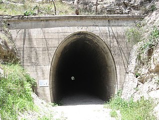
Muntapa Tunnel is a heritage-listed tunnel from Narko-Nutgrove Road, Highgrove through to Nutgrove, both in the Toowoomba Region, Queensland, Australia. It was designed by Queensland Railways and built from 1910 to 1913 by Queensland Railways. It was added to the Queensland Heritage Register on 3 May 2007.

OSheas Drayton Cottage

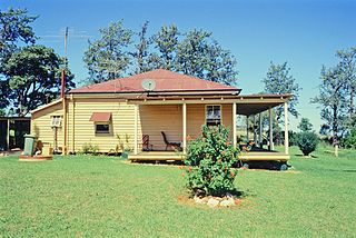
O'Shea's Drayton Cottage is a heritage-listed cottage at 56 Gwynne Street, Drayton, Toowoomba Region, Queensland, Australia. It was built from c. 1874 to 1910s circa. It was added to the Queensland Heritage Register on 27 April 2001.

St Lukes Church Hall, Toowoomba

St Lukes Church Hall is a heritage-listed church hall of St Luke's Anglican Church at 152 Herries Street, Toowoomba City, Toowoomba, Toowoomba Region, Queensland, Australia. It was designed by Henry James (Harry) Marks and built from 1910 to 1911 by H. Andrews. It is also known as St Lukes School & Parish Hall. It was added to the Queensland Heritage Register on 21 October 1992.

Toowoomba Foundry

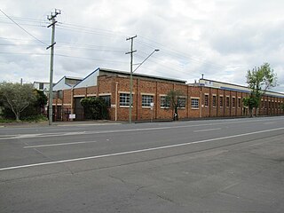
Toowoomba Foundry Pty Ltd is a heritage-listed former foundry at 251-267 Ruthven Street, Toowoomba, Queensland, Australia. It was built from c. 1910 to 1940s. It is also known as Griffiths Brothers & Company, Southern Cross Works, and Toowoomba Foundry and Railway Rolling Stock Manufacturing Company. It was added to the Queensland Heritage Register on 7 July 2004. The northern and western portions of the site have undergone redevelopment as a Bunnings Warehouse outlet, having obtained Toowoomba Regional Council approval to demolish some of the heritage-listed structures on the site. Construction commenced in late 2016, with the store opening in late 2017.

Sandstone Railway Culvert, Wulkuraka

The Sandstone Railway Culvert is a heritage-listed railway culvert at Wulkuraka, City of Ipswich, Queensland, Australia. It was built c. 1865. It was added to the Queensland Heritage Register on 24 June 2005.

Spicers Gap Road Historic road in Queensland, Australia

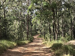
Spicers Gap Road is a heritage-listed road at Spicers Gap Road Conservation Park, Tregony, Southern Downs Region, Queensland, Australia. It was built from 1859 to 1865. It is also known as Spicers Gap Road Conservation Park and Spicers Peak Road. It was added to the Queensland Heritage Register on 23 July 1999.

Ipswich Town Wharves

Ipswich Town Wharves are heritage-listed remnants of wharves beside the Bremer River at Bremer Street, North Ipswich, City of Ipswich, Queensland, Australia. They were built from 1847 to c. 1927. They were also known as Australasian Steam Navigation Wharf and William Collins and Son Wharf, J & G Harris Wharf, and Walter Gray and Co Wharf. They were added to the Queensland Heritage Register on 31 July 2006.

Tregony, Queensland Suburb of Southern Downs Region, Queensland, Australia

Tregony is a locality in the Southern Downs Region, Queensland, Australia. It is one of the major gateways to the Darling Downs from the Queensland coast.

References

  1. 1 2 3 4 5 6 7 8 9 10 11 12 13 "Corduroy Road Remains, Laidley (entry 600657)". Queensland Heritage Register . Queensland Heritage Council. Retrieved 1 August 2014.

Attribution

CC-BY-icon-80x15.png This Wikipedia article was originally based on "The Queensland heritage register" published by the State of Queensland under CC-BY 3.0 AU licence (accessed on 7 July 2014, archived on 8 October 2014). The geo-coordinates were originally computed from the "Queensland heritage register boundaries" published by the State of Queensland under CC-BY 3.0 AU licence (accessed on 5 September 2014, archived on 15 October 2014).

Commons-logo.svg Media related to Corduroy Road Remains at Wikimedia Commons