
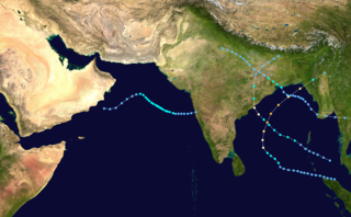
Typhoon Gay, also known as the Kavali Cyclone of 1989, was a small but powerful tropical cyclone which caused more than 800 fatalities in and around the Gulf of Thailand in November 1989. The worst typhoon to affect the Malay Peninsula in thirty-five years, Gay originated from a monsoon trough over the Gulf of Thailand in early November. Owing to favorable atmospheric conditions, the storm rapidly intensified, attaining winds over 120 km/h by 3 November. Later that day, Gay became the first typhoon since 1891 to make landfall in Thailand, striking Chumphon Province with winds of 185 km/h. The small storm emerged into the Bay of Bengal and gradually reorganized over the following days as it approached southeastern India. On 8 November, Gay attained its peak intensity as a Category 5-equivalent cyclone with winds of 260 km/h. The cyclone then moved ashore near Kavali, Andhra Pradesh. Rapid weakening ensued inland, and Gay dissipated over Maharashtra early on 10 November.
Kakinada is the sixth largest city of the Indian state of Andhra Pradesh and serves as the district headquarters of the Kakinada District. It lies on the coast of the Bay of Bengal. J.N.T.U. College of Engineering Kakinada, established in 1946, is the oldest and popular Government college in the state of Andhra Pradesh. The First Polytechnic college of Andhra Pradesh, Andhra Polytechnic was established here in 1946. It was also the origin point of Buckingham Canal where goods used to be transported by boats during the British rule. It was once home for Asia's largest sea port. Many people from the city migrated from this sea port to countries like Burma, Mauritius, Fiji and various southeast Asian countries to work there as workers where they were called as Coringas.
The years before 1890 featured the pre-1890 North Indian Ocean cyclone seasons. Each season was an event in the annual cycle of tropical cyclone formation. The North Indian tropical cyclone season has no bounds, but they tend to form between April and December, peaks in May and November. These dates conventionally delimit the period of each year when most tropical cyclones form in the northern Indian Ocean. Below are the most significant cyclones in the time period. Because much of the North Indian coastline is near sea level and prone to flooding, these cyclones can easily kill many with storm surge and flooding. These cyclones are among the deadliest on earth in terms of numbers killed.

The 2006 North Indian Ocean cyclone season had no bounds, but cyclones tend to form between April and December, with peaks in May and November. These dates conventionally delimit the period of each year when most tropical cyclones form in the northern Indian Ocean.

The 2003 North Indian Ocean cyclone season was the last season that tropical cyclones were not publicly labeled by India Meteorological Department (IMD). Also was mostly focused in the Bay of Bengal, where six of the seven depressions developed. The remaining system was a tropical cyclone that developed in the Arabian Sea in November, which was also the only system that did not affect land. There were three cyclonic storms, which was below the average of 4–6. Only one storm formed before the start of the monsoon season in June, although it was also the most notable. On May 10, a depression formed in the central Bay of Bengal, and within a few days became a very severe cyclonic storm. After it stalled, it drew moisture from the southwest to produce severe flooding across Sri Lanka, killing 254 people and becoming the worst floods there since 1947. Damage on the island totaled $135 million (2003 USD). The storm eventually made landfall in Myanmar on May 19. It is possible that the storm contributed to a deadly heat wave in India due to shifting air currents.

The 2000 North Indian Ocean cyclone season was fairly quiet compared to its predecessor, with all of the activity originating in the Bay of Bengal. The basin comprises the Indian Ocean north of the equator, with warnings issued by the India Meteorological Department (IMD) in New Delhi. There were six depressions throughout the year, of which five intensified into cyclonic storms – tropical cyclones with winds of 65 mph (105 km/h) sustained over 3 minutes. Two of the storms strengthened into a Very Severe Cyclonic Storm, which has winds of at least 120 km/h (75 mph), equivalent to a minimal hurricane. The Joint Typhoon Warning Center (JTWC) also tracked storms in the basin on an unofficial basis, estimating winds sustained over 1 minute.

The 1977 Andhra Pradesh cyclone was a devastating tropical cyclone that hit Andhra Pradesh in November 1977, killing at least 10,000 people.
The 1995 North Indian Ocean cyclone season was below-average and was primarily confined to the autumn months, with the exception of three short-lived deep depressions in May. There were eight depressions in the basin, which is Indian Ocean north of the equator. The basin is subdivided between the Bay of Bengal and the Arabian Sea on the east and west coasts of India, respectively. Storms were tracked by the India Meteorological Department (IMD), which is the basin's Regional Specialized Meteorological Center, as well as the American-based Joint Typhoon Warning Center (JTWC) on an unofficial basis.

The 1996 North Indian Ocean cyclone season featured several deadly tropical cyclones, with over 2,000 people killed during the year. The India Meteorological Department (IMD) – the Regional Specialized Meteorological Center for the northern Indian Ocean as recognized by the World Meteorological Organization – issued warnings for nine tropical cyclones in the region. Storms were also tracked on an unofficial basis by the American-based Joint Typhoon Warning Center, which observed one additional storm. The basin is split between the Bay of Bengal off the east coast of India and the Arabian Sea off the west coast. During the year, the activity was affected by the monsoon season, with most storms forming in June or after October.

The 1990 Andhra Pradesh cyclone or the 1990 Machilipatnam Cyclone was the worst disaster to affect Southern India since the 1977 Andhra Pradesh cyclone. The system was first noted as a depression on 4 May 1990, while it was located over the Bay of Bengal about 600 km (375 mi) to the southeast of Chennai, India. During the next day the depression intensified into a cyclonic storm and started to intensify rapidly, becoming a super cyclonic storm early on 8 May. The cyclone weakened slightly before it made landfall on India about 300 km (190 mi) to the north of Madras in the Andhra Pradesh state as a very severe cyclonic storm with winds of 165 km/h (105 mph). While over land the cyclone gradually dissipated. The cyclone had a severe impact on India, with over 967 people reported to have been killed. Over 100,000 animals also died in the cyclone with the total cost of damages to crops estimated at over $600 million.

India is a country in the North Indian Ocean that is the most vulnerable to getting hit by tropical cyclones in the basin, from the east or from the west.On average, 2–3 tropical cyclones make landfall in India each year, with about one being a severe tropical cyclone or greater.

Cyclonic Storm Nilam was the deadliest tropical cyclone to directly affect South India since Cyclone Jal in 2010. Originating from an area of low pressure over the Bay of Bengal on October 28, 2012, the system began as a weak depression 550 km (340 mi) northeast of Trincomalee, Sri Lanka. Over the following few days, the depression gradually intensified into a deep depression, and subsequently a cyclonic storm by October 30. It made landfall near Mahabalipuram on October 31 as a strong cyclonic storm with peak winds of 85 km/h (55 mph). In Chennai's Marina Beach, strong winds pushed piles of sand ashore and seawater reached nearly a 100 m (330 ft) inland. Schools and colleges in the city remained closed for more than three days.

Extremely Severe Cyclonic Storm Hudhud was a strong tropical cyclone that caused extensive damage and loss of life in eastern India and Nepal during October 2014. Hudhud originated from a low-pressure system that formed under the influence of an upper-air cyclonic circulation in the Andaman Sea on October 6. Hudhud intensified into a cyclonic storm on October 8 and as a Severe Cyclonic Storm on October 9. Hudhud underwent rapid deepening in the following days and was classified as a Very Severe Cyclonic Storm by the IMD. Shortly before landfall near Visakhapatnam, Andhra Pradesh, on October 12, Hudhud reached its peak strength with three-minute wind speeds of 185 km/h (115 mph) and a minimum central pressure of 960 mbar (28.35 inHg). The system then drifted northwards towards Uttar Pradesh and Nepal, causing widespread rains in both areas and heavy snowfall in the latter.

The 1996 Andhra Pradesh cyclone was a small but powerful storm that left heavy damage in the Indian state of Andhra Pradesh. It formed on 4 November in the eastern Bay of Bengal. Moving westward, it quickly organized and developed a well-defined eye. On 6 November, the cyclone struck about 50 km (30 mi) south of Kakinada, Andhra Pradesh at peak intensity. The India Meteorological Department estimated peak winds of 145 km/h (90 mph), while the American-based Joint Typhoon Warning Center (JTWC) assessed peak winds of 215 km/h (135 mph). Soon after landfall, the cyclone weakened and dissipated by 7 November.

The October 1996 India cyclone had an unusual and protracted path that spanned much of the northern Indian Ocean. It originated in a weather disturbance that formed on October 14 in the southern Bay of Bengal, off India's east coast. Moving westward, it struck Andhra Pradesh on October 17 as a well-defined low-pressure area. It crossed southern India and reorganized in the Arabian Sea off the western coast of India. The system developed into a depression on October 22 and quickly intensified while moving northward. By October 24, the cyclone approached hurricane intensity as it developed an eye, reaching peak winds of at least 110 km/h (70 mph). On October 25, the storm abruptly stalled and weakened off Gujarat, and progressed southwestward as a minimal storm. It was no longer classifiable as a tropical cyclone by October 28, although its remnants persisted until November 2 when they dissipated east of Somalia.

The 1995 India cyclone was a tropical cyclone that struck southeastern India which later spawned a rare snowstorm in Nepal, triggering the deadliest mountain trekking incident in the country's history in November 1995. The storm originated from the monsoon trough on November 7 in the Bay of Bengal, east of India, becoming the penultimate storm of the 1995 North Indian Ocean cyclone season. Moving northwestward, the system gradually intensified while moving toward land, eventually developing an eye in the middle of the convection. Reaching peak winds of at least 120 km/h (75 mph), the India Meteorological Department (IMD) classified the system as a very severe cyclonic storm on November 8, in line with intensity estimates from the American-based Joint Typhoon Warning Center (JTWC). On November 9, the cyclone made landfall near the border of Andhra Pradesh and Orissa. A typical for most November storms, the system continued to the north and dissipated over Nepal on November 11.

Very Severe Cyclonic Storm Titli was a deadly and destructive tropical cyclone that caused extensive damage to Eastern India in October 2018. Titli was the twelfth depression and fifth named storm to form in the 2018 North Indian Ocean cyclone season. Titli originated from a low pressure area in the Andaman Sea on October 7. With warm sea surface temperatures and low wind shear, the low developed into a depression on October 8 in the central Bay of Bengal. It was tracked and followed by the India Meteorological Department (IMD), which also issued warnings and notices for the public. Titli continued to intensify at it moved toward the southeast Indian coast, becoming a very severe cyclonic storm, equivalent to a minimal hurricane on the Saffir–Simpson scale. It attained the intensity at the same time Cyclone Luban in the Arabian Sea was at the same intensity, marking the first instance since 1977 of simultaneous storms. The IMD estimated peak winds of 150 km/h (90 mph), while the American-based Joint Typhoon Warning Center (JTWC) estimated peak winds of 195 km/h (120 mph). Late on October 10, Titli made landfall in Andhra Pradesh, and it quickly weakened over land as it turned to the northeast. It degenerated into a remnant low on October 12.

Severe Cyclonic Storm Phethai was a tropical cyclone which affected some portions of Sri Lanka and India during December 2018. The fourteenth depression, ninth deep depression, seventh cyclonic storm, and fifth severe cyclonic storm of the 2018 North Indian Ocean cyclone season, Phethai developed from an area of low pressure that formed over the Bay of Bengal on December 13. Having forecasted not to develop significantly, the depression then strengthened to a deep depression later that day before becoming a cyclonic storm on December 15. Phethai further intensified and peaked to a severe cyclonic storm, the following day. The system then steadily weakened due to land interaction and increasing wind shear, before making landfall as a disorganized system over Andhra Pradesh on December 17. It degenerated to an area of low-pressure inland, the next day.
On 25 November 1839, the port city of Coringa in Andhra Pradesh on the southeastern coast of British India was battered by a tropical cyclone that destroyed the harbor. Known as the 1839 Coringa cyclone and sometimes also referred to as the 1839 India cyclone and 1839 Andhra Pradesh cyclone, its storm surge caused wide damage. It killed over 300,000 people, making it the second-deadliest storm worldwide after the 1970 Bhola cyclone. Many ships were destroyed and houses were washed out by rising rivers and streams. Croplands were inundated and many animals drowned due to the floods and storm surge.

The 1984 Sriharikota cyclone, officially named Tropical Cyclone 03B, was the worst to hit the central east coast of India in 15 years. It brought intense flooding in the Indian state of Andhra Pradesh and Tamil Nadu, resulting in 604 fatalities. The short-lived storm was the second and most powerful of the 1984 North Indian Ocean cyclone season.

