
Thurston Island is an ice-covered, glacially dissected island, 215 km (134 mi) long, 90 km (56 mi) wide and 15,700 km2 (6,062 sq mi) in area, lying a short way off the northwest end of Ellsworth Land, Antarctica. It is the third largest island of Antarctica, after Alexander Island and Berkner Island.

Dundee Island is an ice-covered island lying east of the northeastern tip of Antarctic Peninsula and south of Joinville Island.

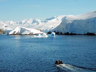
Danco Island or Isla Dedo is an island off Antarctica, 2 kilometres (1 nmi) long lying in the southern part of Errera Channel, off the west coast of Graham Land. It was charted by the Belgian Antarctic Expedition under Adrien de Gerlache, 1897–1899. Danco Island was surveyed by the Falkland Islands Dependencies Survey from Norsel in 1955, and named by the UK Antarctic Place-names Committee for Emile Danco (1869–1898), a Belgian geophysicist and member of the Belgian Antarctic Expedition, who died on board Belgica in the Antarctic.

The Dailey Islands are a group of small volcanic islands lying off the coast of Victoria Land, 9 kilometres (5 nmi) northeast of Cape Chocolate, in the northern part of the ice shelf bordering McMurdo Sound. They were discovered by the British National Antarctic Expedition, 1901–04, under Robert Falcon Scott, and named for Fred E. Dailey, the expedition carpenter.

The Windmill Islands are an Antarctic group of rocky islands and rocks about 11.1 kilometres (6 nmi) wide, paralleling the coast of Wilkes Land for 31.5 kilometres (17 nmi) immediately north of Vanderford Glacier along the east side of Vincennes Bay. Kirkby Shoal is a small shoal area with depths of less than 18 metres (59 ft) extending about 140 metres (459 ft) westwards and SSW, about 3.4 kilometres (2.1 mi) from the summit of Shirley Island, Windmill Islands, and 0.24 kilometres (0.15 mi) NW of Stonehocker Point, Clark Peninsula.

Snow Hill Island is an almost completely snowcapped island, 33 km (21 mi) long and 12 km (7.5 mi) wide, lying off the east coast of the Antarctic Peninsula. It is separated from James Ross Island to the north-east by Admiralty Sound and from Seymour Island to the north by Picnic Passage. It is one of several islands around the peninsula known as Graham Land, which is closer to South America than any other part of the Antarctic continent.

Posadowsky Glacier is a glacier about 9 nautical miles long, flowing north to Posadowsky Bay immediately east of Gaussberg. Posadowsky Bay is an open embayment, located just east of the West Ice Shelf and fronting on the Davis Sea in Kaiser Wilhelm II Land. Kaiser Wilhelm II Land is the part of East Antarctica lying between Cape Penck, at 87°43'E, and Cape Filchner, at 91°54'E, and is claimed by Australia as part of the Australian Antarctic Territory. Other notable geographic features in this area include Drygalski Island, located 45 mi NNE of Cape Filchner in the Davis Sea, and Mirny Station, a Russian scientific research station.
The Melchior Islands are a group of many low, ice-covered islands lying near the center of Dallmann Bay in the Palmer Archipelago, Antarctica. They were first seen but left unnamed by a German expedition under Eduard Dallmann, 1873–74. The islands were resighted and roughly charted by the Third French Antarctic Expedition under Jean-Baptiste Charcot, 1903–05. Charcot named what he believed to be the large easternmost island in the group "Île Melchior" after Vice Admiral Jules Melchior of the French Navy, but later surveys proved Charcot's Île Melchior to be two islands, now called Eta Island and Omega Island. The name Melchior Islands has since become established for the whole island group now described, of which Eta Island and Omega Island form the eastern part, while the Sigma Islands mark the northern limit of the islands. The group was roughly surveyed in 1927 by Discovery Investigations personnel in the RRS Discovery, and was resurveyed by Argentine expeditions in 1942 and 1943, and again in 1948.

Apollo Glacier is a glacier, 9 nautical miles (17 km) long, flowing northeast and joining the lower part of Aphrodite Glacier 2 nautical miles (4 km) from the east coast of the Antarctic Peninsula. The lower part of this glacier was first plotted by W.L.G. Joerg, from aerial photographs taken by Sir Hubert Wilkins in December 1928 and by Lincoln Ellsworth in November 1935. The glacier was subsequently photographed by the Ronne Antarctic Research Expedition in December 1947 and roughly surveyed by the Falkland Islands Dependencies Survey in November 1960. It was named by the UK Antarctic Place-Names Committee after Apollo, the god of manly youth and beauty in Greek mythology.
Deadmond Glacier is a glacier about 6 nautical miles (11 km) long, flowing from the east side of Evans Peninsula on Thurston Island into Cadwalader Inlet. It was discovered by the U.S. Navy Bellingshausen Sea Expedition in February 1960, and was named by the Advisory Committee on Antarctic Names for Lieutenant Commander Robert B. Deadmond, executive officer of USS Burton Island, forming part of this expedition.
Delius Glacier is a glacier, 6 nautical miles (11 km) long and 2 nautical miles (4 km) wide, flowing west from the Elgar Uplands into Nichols Snowfield, in the northern part of Alexander Island, Antarctica. It was first seen from the air and roughly mapped by the British Graham Land Expedition in 1937. It was more accurately mapped from air photos taken by the Ronne Antarctic Research Expedition, 1947–48, by D. Searle of the Falkland Islands Dependencies Survey in 1960, and from U.S. Landsat imagery of February 1975. It was named by the UK Antarctic Place-Names Committee after Frederick Delius, the British composer.

Dufayel Island is an island lying near the center of Ezcurra Inlet, Admiralty Bay, in the South Shetland Islands. It was charted and named in December 1909 by the French Antarctic Expedition under Jean-Baptiste Charcot.

Gerry Glacier is a glacier on Edward VII Peninsula, Antarctica, flowing north between Reeves Peninsula and the Howard Heights to the head of Sulzberger Bay. Features in this area were photographed from the air and mapped by the Byrd Antarctic Expeditions, 1928–30 and 1933–35. This glacier was mapped by the United States Geological Survey from surveys and U.S. Navy air photos, 1959–65, and was named by the Advisory Committee on Antarctic Names for U.S. Senator Peter G. Gerry of Rhode Island, a long-time friend of the Byrd family and a contributor to the 1933–35 expedition.

Gnomon Island is a small rocky island lying just north of Point Wild, on Elephant Island in the South Shetland Islands. It was charted by Ernest Shackleton's Endurance expedition, 1914–16, and so named by them because when viewed from Point Wild the shape of the feature is suggestive of a gnomon, the elevated arm of a sundial.

González Island is a small island on the south side of the entrance to Iquique Cove, Discovery Bay, Greenwich Island in the South Shetland Islands. On its west side the island is linked by a split to a smaller island, which is covered at high tide. The island was charted by the Chilean Antarctic Expedition of 1947, and commanded by Capitan de Navio Federico Guesalaga Toro, who named it after Ernesto González Navarrete, captain of the ship Iquique on the expedition.
The Moss Islands are a group of small islands and rocks lying east of Midas Island and north of Apéndice Island in Hughes Bay, off the west coast of Graham Land, Antarctica. They were first charted in detail and given the descriptive name "Moos Inseln" by the Swedish Antarctic Expedition under Otto Nordenskiöld in 1902.
Hariot Glacier is a glacier flowing northwest along the south side of Morgan Upland before turning west into the northern portion of the Wordie Ice Shelf, along the west coast of the Antarctic Peninsula. It was roughly surveyed by the British Graham Land Expedition, 1936–37, and the upper reaches were photographed from the air by the Ronne Antarctic Research Expedition, 1947. The glacier was surveyed from the ground by members of the Falkland Islands Dependencies Survey who travelled along it in December 1958, and it was named by the UK Antarctic Place-Names Committee after Thomas Hariot, an English mathematician who pioneered new methods of navigation under the patronage of Sir Walter Raleigh.
Lofgren Peninsula is an ice-covered peninsula about 22 nautical miles (40 km) long, projecting between Cadwalader Inlet and Morgan Inlet on the northeast side of Thurston Island, Antarctica. The northern extremity of the peninsula is Cape Menzel, a bold rock cape. These features were discovered in helicopter flights from the USS Burton Island and the USS Glacier of the U.S. Navy Bellingshausen Sea Expedition in February 1960, and was named by the Advisory Committee on Antarctic Names. The peninsula was named for Charles E. Lofgren, personnel officer with the Byrd Antarctic Expedition, 1928–30. The cape was named for Reinhard W. Menzel, a geomagnetist-seismologist with the Eights Station winter party, 1965.
McClary Glacier is a glacier 10 nautical miles (19 km) long and 2 nautical miles (4 km) wide on the west coast of Graham Land, Antarctica. It flows southwest along the north side of Butson Ridge into Marguerite Bay between Cape Calmette and the Debenham Islands. The glacier was first roughly surveyed by the British Graham Land Expedition, 1936–37, and resurveyed by the Falkland Islands Dependencies Survey, 1946–50. It was named by the UK Antarctic Place-Names Committee for George B. McClary, father of Nelson McClary, mate on the Port of Beaumont during the Ronne Antarctic Research Expedition, 1947–48.

