
Cottonwood County is a county in the U.S. state of Minnesota. As of the 2020 census, the population was 11,517. Its county seat is Windom.

Mountain Lake Township is a township located in Cottonwood County, Minnesota, United States. According to the 2010 census, the population was 384. The township was organized in 1871.

Cottonwood Heights is a city located in Salt Lake County, Utah, the United States, along the east bench of the Salt Lake Valley. It lies south of the cities of Holladay and Murray, east of Midvale, and north of Sandy within the Salt Lake City, Utah Metropolitan Statistical Area. Following a successful incorporation referendum in May 2004, the city was incorporated on January 14, 2005. Cottonwood Heights had been a Census-designated place (CDP) before incorporation. The population as of the 2010 census was 33,433. This is a significant increase over the CDP's 2000 census count of 27,569.

Mingus Mountain is a mountain located in the U.S. state of Arizona in the Black Hills mountain range. It is located within the Prescott National Forest traversed by State Route 89A approximately midway between Cottonwood and Prescott. The summit can be reached via Forest Service roads that branch off from State Route 89A. From the mountain, there are views of the Verde Valley, Sycamore Canyon Wilderness and the towns of Cottonwood, Jerome, and Clarkdale. The Woodchute Wilderness, north of the summit of 89A, also offers views and hiking trails. There are several National Forest campgrounds in the area and it is the transmitter location for Prescott full-service television station KAZT-TV and several low-power television stations serving Cottonwood, Clarkdale, Camp Verde and Prescott Valley. Mingus Mountain is also the premier flying site of the Arizona Hang Gliding and Paragliding Association.

The Wasatch Range or Wasatch Mountains is a mountain range in the western United States that runs about 160 miles (260 km) from the Utah-Idaho border south to central Utah. It is the western edge of the greater Rocky Mountains, and the eastern edge of the Great Basin region. The northern extension of the Wasatch Range, the Bear River Mountains, extends just into Idaho, constituting all of the Wasatch Range in that state.

Snowbird is an unincorporated community in Little Cottonwood Canyon in the Wasatch Range of the Rocky Mountains near Salt Lake City, Utah, United States. It is most famous for Snowbird Ski and Summer Resort, an alpine skiing and snowboarding area, which opened in December 1971.

Crestone Peak is the seventh-highest summit of the Rocky Mountains of North America and the U.S. state of Colorado. The prominent 14,300-foot (4,359 m) fourteener is the highest summit of the Crestones and the second-highest summit in the Sangre de Cristo Range after Blanca Peak. The summit is located in the Sangre de Cristo Wilderness of Rio Grande National Forest, 5.0 miles (8.1 km) east by south of the Town of Crestone in Saguache County, Colorado, United States.
Browns Park National Wildlife Refuge is a 13,450-acre (5,440 ha) U.S. National Wildlife Refuge located in northwestern Colorado. It is located in Moffat County in the extreme northwestern corner of the state, in an isolated mountain valley of Browns Park on both sides of the Green River, approximately 25 miles (40 km) below Flaming Gorge Dam. Established in 1965, the refuge is managed by the United States Fish and Wildlife Service office in Maybell, Colorado. The refuge is approximately 53 miles (85 km) northwest of Maybell on State Highway 318. The refuge consists of bottomland and adjacent benchland. The western border of the refuge is the Colorado-Utah state line. The refuge is surrounded by adjacent lines of the Bureau of Land Management. The refuge contains the site of the former Fort Davy Crockett that was constructed in 1837 to protect trappers against attacks by Blackfoot Native Americans.
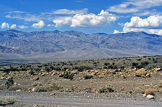
The Cottonwood Mountains range is found in Death Valley National Park in Inyo County, California, U.S.

Big Cottonwood Canyon is a canyon in the Wasatch Range 12 miles (19 km) southeast of Salt Lake City in the U.S. state of Utah. The 15-mile (24 km)-long canyon provides hiking, biking, picnicking, rock-climbing, camping, and fishing in the summer. Its two ski resorts, Brighton and Solitude, are popular among skiers and snowboarders. The canyon is accessed by The Big Cottonwood Canyon Scenic Byway (SR-190), which runs its length to Guardsman Pass at the top of the canyon, allowing travel to Park City in the summer months.

Mount Langley is a mountain located on the crest of the Sierra Nevada, on the boundary between Inyo and Tulare counties in eastern California, in the United States. To the east is the Owens Valley, and to the west is the Kern River Valley. It is the ninth-highest peak in the state and the seventh-highest in the Sierra. Mount Whitney, the highest peak in the contiguous United States, lies 4.8 miles (7.7 km) to the northwest. Mount Langley also has the distinction of being the southernmost fourteener in the United States.
The Table Mountain Wilderness is a protected wilderness area in the Monitor Range of Nye County in central section of the state of Nevada. It is the third largest wilderness area in the state. The nearest city is Tonopah, Nevada. The Table Mountain Wilderness Area covers 92,600 acres (37,500 ha), and is administered by the Humboldt-Toiyabe National Forest. The 1860s ghost town of Belmont is nearby.

The Stikine-LeConte Wilderness is on the mainland of southeast Alaska, southeast of Petersburg and north of Wrangell, Alaska. The boundary extends from Frederick Sound on the west to the Alaska–Canada boundary on the east. The wilderness is 448,841 acres (181,640 ha) in size. It is part of Tongass National Forest, which is managed by the United States Forest Service.
The Cottonwood Mountains are a mountain range in Riverside County, California. They lie between the Little San Bernardino Mountains to the west, and Eagle Mountains to the east and the Hexie Mountains to the north. They are partially included in the Joshua Tree Wilderness.
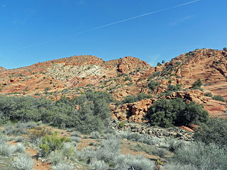
Cottonwood Canyon Wilderness is a 11,712-acre (47.4 km2) wilderness area in the US state of Utah. It was designated March 30, 2009, as part of the Omnibus Public Land Management Act of 2009. Located adjacent to the southern edge of the Dixie National Forest, it encompasses and protects a transition zone between the Colorado Plateau to the east and the Mojave Desert to the west. It is bordered by the Cottonwood Forest Wilderness to the northeast and is itself a part of the Red Cliffs National Conservation Area.
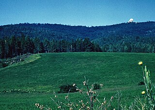
Cottonwood Air Force Station is a former United States Air Force General Surveillance Radar station. The radar site was located at the summit of Cottonwood Butte, 5.7 miles (9.2 km) west-northwest of Cottonwood in Idaho County, Idaho. It was closed in 1965 and transferred to the state of Idaho in 1974, when it was converted to its present use as a minimum-security correctional facility.
House Mountain is a shield volcano located in the U.S. state of Arizona located between the Sedona Red Rock Country and the Verde Valley in the Coconino National Forest. House Mountain erupted approximately 13–15 million years ago on the edge of where the Mogollon Rim stood at that time. Thus, the basalt that was emitted preserved the sedimentary layers below it, including the Schnebly Hill Formation and the thin band of Fort Apache Limestone. The Mogollon Rim has receded at a rate of 1 foot per 600 years since and the current edge of the rim can be seen several miles away from the summit.

Cottonwood Creek is a major stream and tributary of the Sacramento River in Northern California. About 68 miles (109 km) long measured to its uppermost tributaries, the creek drains a large rural area bounded by the crest of the Coast Ranges, traversing the northwestern Sacramento Valley before emptying into the Sacramento River near the town of Cottonwood. For its entire length, it defines the boundary of Shasta and Tehama counties. Because Cottonwood Creek is the largest undammed tributary of the Sacramento River, it is known for its Chinook salmon and steelhead runs.
Cottonwood Pass may refer to:

Kesler Peak is a 10,403-foot elevation (3,171 m) mountain summit located in Salt Lake County, Utah, United States.
