| Council Grove Group | |
|---|---|
| Stratigraphic range: Carboniferous-Permian boundary [1] | |
| Type | Group |
| Sub-units | Speiser Shale Funston Limestone ContentsForaker Limestone |
| Underlies | Chase Group |
| Overlies | Admire Group |
| Location | |
| Region | Midcontinent (Kansas, Nebraska, Oklahoma, Colorado (subsurface) ) |
| Country | United States |
| Type section | |
| Named for | Council Grove, Kansas |
The Council Grove Group is a geologic group in Kansas, Oklahoma, and Nebraska as well as subsurface Colorado. It preserves fossils dating to the Carboniferous-Permian boundary. [1] [2] This group forms the foundations and lower ranges of the Flint Hills of Kansas, underlying the Chase Group that forms the highest ridges of the Flint Hills.
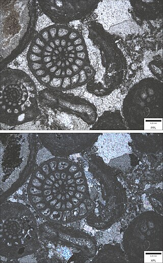
The Group particularly consists of megacyclothems alternating between massive mudstone paleosols and massive shallow marine limestone. The sequences of these alternations correlate with the ~400,000 year component of Milankovitch cycles. A number of the limestones have minor flint-filled marine animal burrows, anticipating the massive flint beds of the Chase Group.
With the exposure of the group's lower formations in the 1993 flooding, [3] the entirety of the Council Grove Group, from hillcrest Speiser Shale down to pond-level Americus limestone, is exposed for study from top to bottom in the Tuttle Creek Lake Spillway. [4]

The Chattanooga Shale is a geological formation in Alabama, Arkansas, Georgia, Kansas, Kentucky, Missouri and Tennessee. It preserves conodont fossils dating to the Devonian period. It occurs mostly as a subsurface geologic formation composed of layers of shale. It is located in East Tennessee and also extends into southeastern Kentucky, northwestern Georgia, and northern Alabama. This part of Alabama is part of the Black Warrior Basin.

The Oread Limestone is a geologic unit of formation rank within the Shawnee Group throughout much of its extent. It is exposed in Kansas, Nebraska, Missouri, Oklahoma, and Iowa. The type locality is Mount Oread within Lawrence, Kansas. It preserves fossils of the Carboniferous period. Although it has significant shale members, its limestone members are resistant and form escarpments and ridges. Limestone from the unit is a historic building material in Kansas, particularly in the early buildings of the University of Kansas; standing examples include Spooner Hall and Dyche Hall.
The Stanton Formation is a geologic formation of limestone in Iowa, Nebraska, Missouri and Kansas. It preserves fossils dating back to the Carboniferous period. It is in the Upper Pennsylvanian series, forming the top of the Lansing Group.
The Janesville Shale or Janesville Formation is a geologic formation in Kansas, Oklahoma, and Nebraska dating to the late Carboniferous period.
The Beattie Formation, or Beattie Limestone, is a geologic formation in east-central Kansas, northeast-central Oklahoma, and southeastern Nebraska in the Midwestern United States. It preserves fossils dating to the Permian period.

The Americus Limestone is a member of the Foraker Limestone Formation in eastern Kansas, where it is quarried as a distinctive ornamental stone. In outcrop, it is typically recognized as two relatively thin but persistent beds of hard limestone separated by shale that forms the lowest prominent bench of the many benches of the Flint Hills. The recognizable facie of the member in excavated or eroded exposures is two thin limestone beds separated a bed of shale and adjacent shales above and below having a particular gray or bluish color darker than higher limestones. A third, lower, highly variable algal limestone is often present and included as the base of the member. The unit is not particularly massive, the limestone pair totaling 3 to 4 feet in places, more in other locations but less to the North, and up to nearly to 9 feet at the type location of Americus, Kansas. The addition of the lower algal limestone as a base for the unit increases the thickness to over 18 feet. Initially thought to be the lowest of the Permian rock of Kansas and as such classified as the lowest unit of the Council Grove Group, the unit is now dated within the uppermost Late Carboniferous.

The Wellington Formation is an Early Permian geologic formation in Kansas and Oklahoma. The formation's Hutchinson Salt Member is more recognized by the community than the formation itself, and the salt is still mined in central Kansas. The Wellington provides a rich record of Permian insects and its beddings provide evidence for reconstruction of tropical paleoclimates of the Icehouse Permian with the ability in cases to measure the passage of seasons. Tens of thousands of insect fossil recovered from the Wellington shales are kept in major collections at the Harvard Museum of Comparative Zoology and Yale Peabody Museum of Natural History.

The Eskridge Shale or Eskridge Formation is an Early Permian geologic formation in Kansas. Its outcrop runs north–south through Kansas, extending into Oklahoma and Nebraska. While named a shale, it features extensive, spectacular red and green stacked palosol mudstones, these mudstones showing prominent vertical tubular carbonate concretions, possibly from roots or vertebrate burrows.

The Foraker Formation is a geologic formation in Nebraska, Kansas, and Oklahoma. It preserves fossils dating to the Carboniferous period.

The Johnson Formation is a thick geologic formation of soft shale with thin, resistant beds of chalkier mudstone and limestone in Nebraska, Kansas, and Oklahoma rarely exposed outside of road cuts. It preserves fossils dating back to the late-Carboniferous period.
The Red Eagle Formation is a geologic formation ranging from Oklahoma, through Kansas, into southeast Nebraska of the United States. Its members define the Carboniferous-Permian boundary in Kansas.
The Grenola Formation is an early Permian geologic formation (Wolfcampian) with its exposure running north and south through Kansas and extending into Nebraska and Oklahoma, notably having the Neva Limestone member, which is a terrace-forming aquifer and historic Flint Hills building stone source secondary to the Cottonwood Limestone.
The Arroyo Formation, sometimes termed the Lower Clear Fork Formation, is a geologic formation in Texas. It preserves fossils dating back to the Kungurian stage of the Permian period. It is the lower-most portion of the Clear Fork Group, part of a series of fossiliferous Permian strata in the south-central United States known as the red beds.

The Benton Shale is a geologic formation name historically used in Montana, Wyoming, North Dakota, South Dakota, Colorado, Kansas, and Nebraska. In the "mile high" plains in the center of the continent, the named layers preserve marine fossils from the Late Cretaceous Period. The term Benton Limestone has also been used to refer to the chalky portions of the strata, especially the beds of the strata presently classified as Greenhorn Limestone, particularly the Fencepost limestone.

Cottonwood Limestone, or simply the Cottonwood, is a stratigraphic unit and a historic stone resource in east-central Kansas, northeast-central Oklahoma, and southeastern Nebraska in the Midwestern United States. It is the lowest member of the Beattie Limestone formation and commonly outcrops within the deep valleys and on top of the scenic residual ridges of the Flint Hills.
The Morrill Limestone is a stratigraphic unit in east-central Kansas, northeast-central Oklahoma, and southeastern Nebraska in the Midwestern United States. It preserves fossils dating to the Permian period.
The Florena Shale is a stratigraphic unit in east-central Kansas, northeast-central Oklahoma, and southeastern Nebraska in the Midwestern United States. It preserves fossils dating to the Permian period.
The Neva Limestone is a stratigraphic unit and historic building stone in east-central Kansas, northeast-central Oklahoma, and southeastern Nebraska in the Midwestern United States. It preserves fossils dating to the Permian period.

The Fort Riley Limestone is a Kansas Permian stratigraphic unit of member rank and historic building stone, sold commercially as fine-grained Silverdale, having at one time been quarried at Silverdale, Kansas. This limestone outcrops in east-central Kansas, extending into northeast-central Oklahoma and southeastern Nebraska, in the Midwestern United States. Its conspicuous "rim rock" marker horizon outcrop caps the bluffs overlooking the original buildings of Fort Riley, as well as the Marshall Army Airfield opposite the Kansas River.

The Roca Formation is an early Permian geologic formation (Wolfcampian) with its exposure running north and south through Kansas and extending into Nebraska and Oklahoma, notably comprising varicolored black, brown, gray, green, red, and blue shales, mudstones, and limestone, some of which representing Permian paleosols.
... the Carboniferous-Permian boundary in Kansas can now be confidently defined. Based [on fossil changes, the] boundary in Kansas can be placed at the base of the Bennett Shale Member of the Red Eagle Limestone.
{{cite journal}}: CS1 maint: multiple names: authors list (link){{cite journal}}: CS1 maint: multiple names: authors list (link){{cite journal}}: Cite journal requires |journal= (help)| | This article about a specific stratigraphic formation in Kansas is a stub. You can help Wikipedia by expanding it. |
| | This article about a specific stratigraphic formation in Nebraska is a stub. You can help Wikipedia by expanding it. |
| | This article about a specific stratigraphic formation in Oklahoma is a stub. You can help Wikipedia by expanding it. |
| | This article related to the Permian period is a stub. You can help Wikipedia by expanding it. |