
The Santa Clara River is an 83 mi (134 km) long river in Ventura and Los Angeles counties in Southern California. It drains parts of four ranges in the Transverse Ranges System north and northwest of Los Angeles, then flows west onto the Oxnard Plain and into the Santa Barbara Channel of the Pacific Ocean.

The Santa Ana River is the largest river entirely within Southern California in the United States. It rises in the San Bernardino Mountains and flows for most of its length through San Bernardino and Riverside counties, before cutting through the northern Santa Ana Mountains via Santa Ana Canyon and flowing southwest through urban Orange County to drain into the Pacific Ocean. The Santa Ana River is 96 miles (154 km) long, and its drainage basin is 2,650 square miles (6,900 km2) in size.

The San Gabriel River is a mostly urban waterway flowing 58 miles (93 km) southward through Los Angeles and Orange Counties, California in the United States. It is the central of three major rivers draining the Greater Los Angeles Area, the others being the Los Angeles River and Santa Ana River. The river's watershed stretches from the rugged San Gabriel Mountains to the heavily developed San Gabriel Valley and a significant part of the Los Angeles coastal plain, emptying into the Pacific Ocean between the cities of Long Beach and Seal Beach.

The Arroyo Seco, meaning "dry stream" in Spanish, is a 24.9-mile-long (40.1 km) seasonal river, canyon, watershed, and cultural area in Los Angeles County, California. The area was explored by Gaspar de Portolà who named the stream Arroyo Seco as this canyon had the least water of any he had seen. During this exploration he met the Chief Hahamog-na (Hahamonga) of the Tongva Indians.

The Metropolitan Water District of Southern California is a regional wholesaler and the largest supplier of treated water in the United States. The name is usually shortened to "Met," "Metropolitan," or "MWD." It is a cooperative of fourteen cities, eleven municipal water districts, and one county water authority, that provides water to 19 million people in a 5,200-square-mile (13,000 km2) service area. It was created by an act of the California State Legislature in 1928, primarily to build and operate the Colorado River Aqueduct. Metropolitan became the first contractor to the State Water Project in 1960.

The Mokelumne River is a 95-mile (153 km)-long river in northern California in the United States. The river flows west from a rugged portion of the central Sierra Nevada into the Central Valley and ultimately the Sacramento–San Joaquin River Delta, where it empties into the San Joaquin River-Stockton Deepwater Shipping Channel. Together with its main tributary, the Cosumnes River, the Mokelumne drains 2,143 square miles (5,550 km2) in parts of five California counties. Measured to its farthest source at the head of the North Fork, the river stretches for 157 miles (253 km).

The California State Coastal Conservancy is a non-regulatory state agency in California established in 1976 to enhance coastal resources and public access to the coast. The CSCC is a department of the California Natural Resources Agency. The agency's work is conducted along the entirety of the California coast, including the interior San Francisco Bay and is responsible for the planning and coordination of federal land sales to acquire into state land as well as award grant funding for improvement projects. The Board of Directors for the agency is made up of seven members who are appointed by the Governor of California and approved by the California Legislature, members of the California State Assembly and California State Senate engage and provide oversight within their legislative capacity.
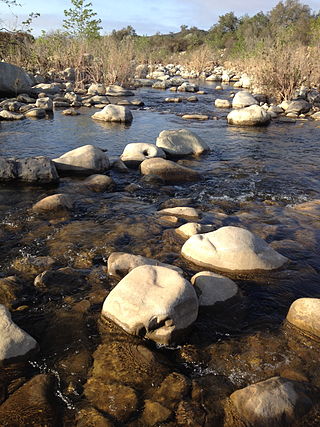
The Ventura River, in western Ventura County in southern California, United States, flows 16.2 miles (26.1 km) from its headwaters to the Pacific Ocean. The smallest of the three major rivers in Ventura County, it flows through the steeply sloped, narrow Ventura Valley, with its final 0.7 miles (1.1 km) through the broader Ventura River estuary, which extends from where it crosses under a 101 Freeway bridge through to the Pacific Ocean.
The Sierra Nevada Alliance is a network of conservation groups encompassing 24 watersheds of the 650 kilometer-long Sierra Nevada in California and Nevada. Beginning in 1993, the Alliance protects and restores Sierra Nevada lands, watersheds, wildlife and communities.
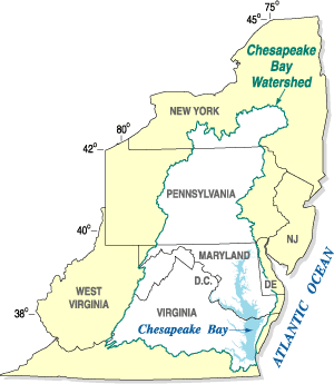
The Chesapeake Bay Program is the regional partnership that directs and conducts the restoration of the Chesapeake Bay in the United States. As a partnership, the Chesapeake Bay Program brings together members of various state, federal, academic and local watershed organizations to build and adopt policies that support Chesapeake Bay restoration. By combining the resources and unique strengths of each individual organization, the Chesapeake Bay Program is able to follow a unified plan for restoration. The program office is located in Annapolis, Maryland.
Water supply and sanitation in the United States involves a number of issues including water scarcity, pollution, a backlog of investment, concerns about the affordability of water for the poorest, and a rapidly retiring workforce. Increased variability and intensity of rainfall as a result of climate change is expected to produce both more severe droughts and flooding, with potentially serious consequences for water supply and for pollution from combined sewer overflows. Droughts are likely to particularly affect the 66 percent of Americans whose communities depend on surface water. As for drinking water quality, there are concerns about disinfection by-products, lead, perchlorates, PFAS and pharmaceutical substances, but generally drinking water quality in the U.S. is good.
Clean Water Services is the water resources management utility for more than 600,000 residents in urban Washington County, Oregon and small portions of Multnomah County, Oregon and Clackamas County, Oregon, in the United States. Clean Water Services operates four wastewater treatment facilities, constructs and maintains flood management and water quality projects, and manages flow into the Tualatin River to improve water quality and protect fish habitat. They are headquartered in Hillsboro.

The Land Conservancy of San Luis Obispo County (LCSLO) is a non-profit land trust organization that has been operating in San Luis Obispo County, California since 1984. The LCSLO is dedicated to the voluntary and collaborative preservation and improvement of lands that hold significant scenic, agricultural, habitat, and cultural values. Their work aims to benefit both the local community and wildlife that depends on these lands.

The Palos Verdes Peninsula Land Conservancy (PVPLC) is a non-profit organization that is based on the Palos Verdes Peninsula in southwestern Los Angeles County, California.
The Southern California Coastal Water Research Project (SCCWRP) is a research institute focusing on the coastal ecosystems of Southern California from watersheds to the ocean. SCCWRP was created as a joint powers authority (JPA), which is an agency formed when multiple government agencies have a common mission that can be better achieved by pooling resources and knowledge. The purpose of SCCWRP is to gather the necessary scientific information to allow member agencies to effectively and cost-efficiently steward the Southern California coastal environment.
The West Fork Conservancy is a 501(c)(3) non-profit volunteer organization which collects, bags, and hauls trash and human waste out of the San Gabriel River located within the Angeles National Forest of the San Gabriel Mountains. The Conservancy also removes Graffiti, assists in extinguishing illegal camp fires and cooking fires, and performs whatever other tasks that the United States Forest Service requests of the organization.

The San Gabriel and Lower Los Angeles Rivers and Mountains Conservancy (RMC) is an agency of the State of California in the United States with the mission of preserving open space and habitat for low-impact recreation and educational uses, wildlife habitat restoration and protection, and watershed improvements within its jurisdiction. The conservancy was created by the state legislature in 1999, and is headquartered in Azusa. It is 1 of 10 conservancies within the California Natural Resources Agency. At the time of its founding, it was the state's first conservancy to primarily serve an urban area.

Ventura–San Gabriel Coastal water resource basin is one of three hydrologic basins within the Southern California Coastal water resource subregion and is one of approximately 2,200 water resource basins in the United States hydrologic unit system. The Ventura–San Gabriel Coastal water resource basin is a third-level subdivision of the United States hydrologic unit system.
One Water is a term encompassing the management of all water sources in an integrated and sustainable way considering all water sources and uses. This idea stems from core principles of providing affordable water access for everyone.