
Norfolk is a rural and non-metropolitan county in East Anglia in England. Norfolk is the fifth largest ceremonial county in England, with an area of 5,371 km2. It borders Lincolnshire to the northwest, Cambridgeshire to the west and southwest, and Suffolk to the south. Its northern and eastern boundaries are the North Sea and to the northwest, The Wash. The county town is the city of Norwich. With an area of 2,074 square miles (5,370 km2) and a population of 859,400, Norfolk is a largely rural county with a population density of 401 per square mile. Of the county's population, 40% live in four major built up areas: Norwich (213,000), Great Yarmouth (63,000), King's Lynn (46,000), and Thetford (25,000).

The Bure Valley Railway is a 15 in minimum gauge heritage railway in Norfolk

Norwich is a city and district of Norfolk, England, of which it is the county town. Norwich is by the River Wensum, about 100 miles (160 km) north-east of London, 40 miles (64 km) north of Ipswich and 65 miles (105 km) east of Peterborough. As the seat of the See of Norwich, with one of the country's largest medieval cathedrals, it is the largest city in East Anglia.
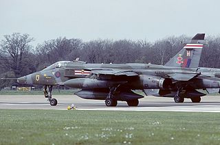
Royal Air Force Coltishall, more commonly known as RAF Coltishall, is a former Royal Air Force station located 10 miles (16 km) North-North-East of Norwich, in the English county of Norfolk, East Anglia, which operated from 1938 to 2006.

Royal Air Force Coningsby or RAF Coningsby, is a Royal Air Force (RAF) station located 13.7 kilometres (8.5 mi) south-west of Horncastle, and 15.8 kilometres (9.8 mi) north-west of Boston, in the East Lindsey district of Lincolnshire, England. It is a Main Operating Base of the RAF and home to three front-line Eurofighter Typhoon FGR4 units, No. 3 Squadron, No. 11 Squadron and No. 12 Squadron. In support of front-line units, No. 29 Squadron is the Typhoon Operational Conversion Unit and No. 41 Squadron is the Typhoon Operational Evaluation Unit. Coningsby is also the home of the Battle of Britain Memorial Flight (BBMF) which operates a variety of historic RAF aircraft.
Number 54 Squadron is a squadron of the Royal Air Force based at RAF Waddington, Lincolnshire. On 1 September 2005, it took on the role of Intelligence, Surveillance and Reconnaissance (ISR) Operational Conversion Unit, and is currently responsible for training all RAF crews assigned to the MQ-9A Reaper, Shadow R1/R2, RC-135W Rivet Joint and Poseidon MRA1. It also controls the RAF ISR Warfare School (ISRWS) who run the Qualified Weapons Instructor Intelligence, Surveillance and Reconnaissance and QWI Reaper Courses.

Carrow Road is an association football stadium located in Norwich, Norfolk, England, and is the home of Premier League side Norwich City. The stadium is located toward the east of the city, near Norwich railway station and the River Wensum.
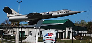
A gate guardian or gate guard is a withdrawn piece of equipment, often an aircraft, armoured vehicle, artillery piece, or locomotive, mounted on a plinth and used as a static display near to and forming a symbolic display of "guarding" the main entrance to a site, especially a military base. Commonly, gate guardians outside airbases are decommissioned examples of aircraft that were once based there, or still are.

The City of Norwich Aviation Museum is a volunteer-run museum and charitable trust dedicated to the preservation of the aviation history of the county of Norfolk, England. The museum is located on the northern edge of Norwich International Airport and is reached by road through the village of Horsham St Faith. The museum welcomed its newest exhibit in October 2020 when it received EL-RJN this aircraft is 21 years old and is an Avro RJ85.

Swanton Morley is a village and civil parish situated in the English county of Norfolk. It is situated in the heart of Norfolk 18 miles from the centre of Norwich and three miles from Dereham, at the geographical centre of Norfolk. It covers an area of 11.14 km2 (4.30 sq mi) and had a population of 2,415 in 783 households at the 2001 census, reducing to a population of 2,100 in 723 households at the 2011 Census. For the purposes of local government it is in the Elmham and Mattishall Division of Norfolk County Council and the Lincoln Ward of Breckland District Council.

Lamas is a village in Broadland, Norfolk, England. Administratively it falls within the civil parish of Buxton with Lamas.
Trowse, also called Trowse with Newton, is a village in South Norfolk which lies about 1+1⁄2 miles (2.4 km) south-east of Norwich city centre on the banks of the River Yare. It covers an area of 4.49 km2 (1.73 sq mi) and had a population of 479 in 233 households at the 2001 census, the population increasing to 862 in 374 households at the 2011 Census. There are approved plans to build a further 770 houses on the outskirts of the village, at White Horse Lane and the Deal Ground sites.
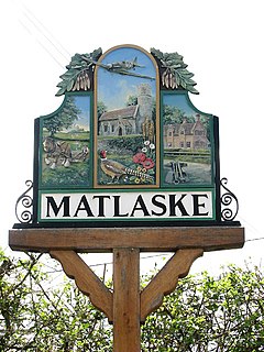
Matlaske is a village and a civil parish in the English county of Norfolk. The village is 21.6 miles (34.8 km) North-north-west of Norwich, 9.3 miles (15.0 km) south-west of Cromer and 136 miles (219 km) north-north-east of London. The nearest railway station is at Sheringham for the Bittern Line which runs between Sheringham, Cromer and Norwich. The nearest airport is Norwich International Airport. The parish of Matlask in the 2001 census, a population of 124, increasing to 139 at the 2011 Census. For the purposes of local government, the parish falls within the district of North Norfolk.

North Norfolk District Council Headquarters is located in Holt road in a prominent position south of the town of Cromer in the English county of Norfolk. It was built between 1988 and 1990. The nearest railway station is at Cromer for the Bittern Line which runs between Sheringham, Cromer and Norwich. The nearest airport is Norwich International Airport.
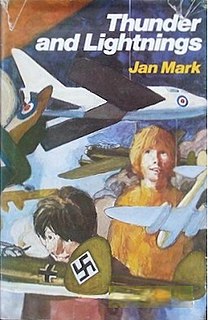
Thunder and Lightnings is a realistic children's novel by Jan Mark, published in 1976 by Kestrel Books of Harmondsworth in London, with illustrations by Jim Russell. Set in Norfolk, it features a developing friendship between two boys who share an interest in aeroplanes, living near RAF Coltishall during the months in 1974 when the Royal Air Force is phasing out its English Electric Lightning fighters and introducing the SEPECAT Jaguar.

The Martineau family is an intellectual, business and political dynasty associated first with Norwich and later also London and Birmingham, England. The family were prominent Unitarians; a room in London's Essex Hall, the headquarters building of the British Unitarians, was named after them. Martineau Place in Birmingham's Central Business District was named in their honour.

Carrow Abbey is a former Benedictine priory in Bracondale, southeast Norwich, England. The village on the site used to be called Carrow and gives its name to Carrow Road, the football ground of Norwich F.C., located just metres to the north. Granted by charter of King Stephen, the abbey was founded ca. 1146, and became a Grade I listed building in 1954.

Edward Boardman (1833–1910) was a Norwich born architect. He succeeded John Brown as the most successful Norwich architect in the second half of the 19th century. His work included both civic and ecclesiastical buildings, in addition to private commissions. Together, with his rival, George Skipper, he produced many notable buildings with several standing to this day (2013).

Earlham Road Cemetery, Norwich also known as Earlham Cemetery or Norwich Cemetery is a cemetery located in Norwich which was officially opened on 6 March 1856 and covers 34 acres (14 ha). The cemetery is divided into two distinct sites by Farrow Road A140 which runs north–south across the site. To the east of the road is the original 19th century cemetery and to the west of the road lies the 20th century addition. Today, it caters for all faiths with separate burial grounds and chapels for Jews and Catholics and a growing one for Muslims together with two military cemeteries. The 19th century cemetery is designed with an informal garden cemetery layout with winding paths while the remainder is a more formal grid type which was favoured by cemetery designer John Claudius Loudon. Much of the original cemetery is a County Wildlife Site and contains grassland and a wide selection of mature trees.

The Shirehall is a municipal facility in Market Avenue, Norwich, Norfolk. It is a Grade II listed building.

