County Hall, Oxford

Last updated

County Hall, Oxford
County Hall, New Road, Oxford.jpg
County Hall, New Road, Oxford
Location Oxford, Oxfordshire
Coordinates 51°45′06″N1°15′42″W / 51.7518°N 1.2618°W / 51.7518; -1.2618
Built1841
Architect John Plowman
Architectural style(s) Gothic Revival style
Listed Building – Grade II*
Designated29 January 1968
Reference no.1047201
Oxfordshire UK location map.svg
Red pog.svg
Location of County Hall, Oxford in Oxfordshire

County Hall is a municipal building on New Road in Oxford, Oxfordshire, England. County Hall, which is the headquarters of Oxfordshire County Council, is a Grade II* listed building. [1]

Contents

History

In the early 16th century the assizes and quarter sessions were held in a sessions house in the grounds of Oxford Castle but towards the end of the century they were moved to Oxford Town Hall. [2] After deciding in the early 19th century that this arrangement was inadequate for their needs, the justices decided to procure a dedicated building within, what was then, the castle grounds. [2]

The building, which was designed by John Plowman in the Gothic Revival style, was completed in 1841. [1] [3] The design involved a symmetrical castellated main frontage of five bays facing New Road: the central section featured a projecting castellated porch containing a round headed doorway with a small round headed window above encircled with the inscription "County Hall A.D. MDCCCXLI" ("County Hall A.D. 1841"); there were turrets at roof level and the other bays contained round headed windows. [1] Sir Charles Oman described it as "quite the most abominable pseudo-Gothic Assize Court in all England". [4]

The building continued to be used as a facility for dispensing justice but, following the implementation of the Local Government Act 1888, which established county councils in every county, it also became the meeting place of Oxfordshire County Council. [5]

County Offices (now the Register Office), 1 Tidmarsh Lane Register Office, 1 Tidmarsh Lane, Oxford.jpg
County Offices (now the Register Office), 1 Tidmarsh Lane

The limited office space at County Hall required the council to establish other premises for its staff. In 1911–1912 a new building called "County Offices" was built at the corner of Tidmarsh Lane and New Road, lying on the opposite side of the castle mound from County Hall. County Offices was designed by William Austin Daft and built in white limestone with yellow sandstone dressings. Council meetings continued to be held at County Hall, with County Offices being the main administrative building. [6] [7]

New County Hall County Hall, New Road, Oxford (1973 extension).jpg
New County Hall

By the early 1970s the council had outgrown County Offices. A modern facility, known as "New County Hall", was designed by the County Architect to accommodate the County Council's administrative staff: it was built adjacent to the original 1841 County Hall and was completed in 1973. [8] [9] [lower-alpha 1] The design for the five-storey building involved continuous bands of glazing with concrete panels above and below. [12]

The old building continued to be used as a courthouse – it was the venue for the trial and conviction of Donald Neilson for the kidnapping and murder of Lesley Whittle in July 1976 [13] – until the new Oxford Combined Court Centre in St Aldate's was completed in October 1985. [14] Meetings of the county council continued to be held in the council chamber located within the old County Hall. [15]

The 1912 County Offices at Tidmarsh Lane is now used as the Oxford register office. [16] The county record office, which had been based in the basement of the new County Hall, moved to St Luke's Church in Temple Cowley in January 2001. [17]

Notes

  1. New County Hall was built on the site of the Swan & Castle Public House which was built in 1896 and demolished in 1968, as well as the Salvation Army Citadel which was built in 1888 and also demolished in 1968. [10] [11]

Related Research Articles

<span class="mw-page-title-main">Oxfordshire</span> County of England

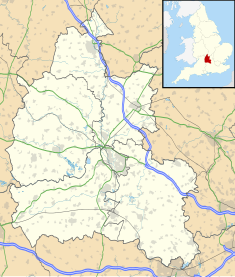
Oxfordshire is a ceremonial county in South East England. The county is bordered by Northamptonshire and Warwickshire to the north, Buckinghamshire to the east, Berkshire to the south, and Wiltshire and Gloucestershire to the west. The city of Oxford is the largest settlement and county town.

<span class="mw-page-title-main">St Stephen's House, Oxford</span> Anglican Theological College

St Stephen's House is an Anglican theological college in Oxford, England. From 2003 to 2023 it was a permanent private hall of the University of Oxford.

<span class="mw-page-title-main">Oxfordshire County Council</span> British administrative authority

Oxfordshire County Council is the county council for the non-metropolitan county of Oxfordshire in the South East of England. Established in 1889, it is an elected body responsible for most strategic local government services in the county.

<span class="mw-page-title-main">Deddington</span> Human settlement in England

Deddington is a civil parish and small town in Oxfordshire about 6 miles (10 km) south of Banbury. The parish includes two hamlets: Clifton and Hempton. The 2011 Census recorded the parish's population as 2,146. Deddington is a small settlement but has a commercial centre including a market place, which hosts a popular monthly farmer’s market. It has been a market town probably since the 12th century. One of the Hundred Rolls of King Edward I from 1275–76 records Deddington as a borough. It has a deli, coffee shop, restaurant, three pubs and a town hall. Its football team is called Deddington Town FC.

Wheatley is a village and civil parish in Oxfordshire, about 5 miles (8 km) east of Oxford. The parish includes the hamlet of Littleworth, which is immediately to the west of Wheatley village. The 2011 census recorded the parish population as 3,913.

Bullingdon Rural District was a rural district in Oxfordshire, England from 1932 to 1974, covering an area to the south-east of the city of Oxford.

<span class="mw-page-title-main">Westgate Oxford</span> Shopping mall in Oxford, England

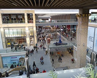
Westgate Oxford is a major shopping centre in Oxford city centre, England, that was extensively remodelled and extended between 2016 and 2017.

<span class="mw-page-title-main">Park End Street</span> Street in central Oxford, England

Park End Street is a street in central Oxford, England, to the west of the centre of the city, close to the railway station at its western end.

<span class="mw-page-title-main">St John the Evangelist Church, Oxford</span> Church in Oxford, England

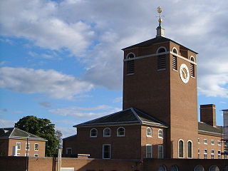
St John the Evangelist Church is a non-parochial church on Iffley Road in Oxford, England. It was built as the community church of the mother house of the Anglican religious order known as the Society of St. John the Evangelist. Since 1980 it has served also as one of the college chapels of St Stephen's House, Oxford.

<span class="mw-page-title-main">William Wilkinson (architect)</span> British architect (1819–1901)

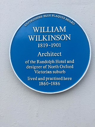
William Wilkinson (1819–1901) was a British Gothic Revival architect who practised in Oxford, England.

<span class="mw-page-title-main">New Road, Oxford</span> Street in west central Oxford, England

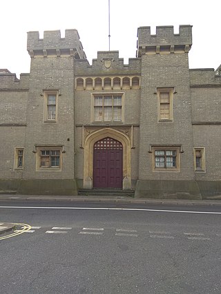
New Road is a street in west central Oxford, England. It links Park End Street and Worcester Street to the west with Queen Street and Castle Street to the east. To the south is Oxford Castle and the former Oxford Prison, now a Malmaison hotel. To the north is Nuffield College, a graduate college of Oxford University. At the eastern end on the south side is New County Hall, the headquarters of Oxfordshire County Council.

<span class="mw-page-title-main">T. Lawrence Dale</span> English architect (1884–1959)

Thomas Lawrence Dale, FRIBA, FSA was an English architect. Until the First World War he concentrated on designing houses for private clients. From the 1930s Dale was the Oxford Diocesan Surveyor and was most noted for designing, restoring, and furnishing Church of England parish churches.

<span class="mw-page-title-main">Frederick Codd</span>

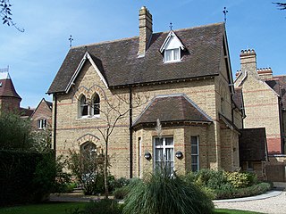
Frederick Codd was a British Gothic Revival architect and speculative builder who designed and built many Victorian houses in North Oxford, England.

<span class="mw-page-title-main">East Suffolk County Hall</span> County building in Ipswich, East Suffolk, England

East Suffolk County Hall is a historic building located in St Helen's Street in Ipswich. The building, which was the headquarters of East Suffolk County Council until 1974 and then of Suffolk County Council until 2004, is a Grade II listed building.

<span class="mw-page-title-main">Devon County Hall</span> County building in Exeter, Devon, England

Devon County Hall is a municipal building in Topsham Road, Exeter, Devon, England. The building, which is the headquarters of Devon County Council, is a Grade II* listed building.

<span class="mw-page-title-main">Timeline of Oxford</span> Timeline of English town

The following is a timeline of the history of the city, university and colleges of Oxford, England.

<span class="mw-page-title-main">County Hall, Chelmsford</span> County building in Chelmsford, Essex, England

Essex County Hall is a municipal building in Market Road, Chelmsford, Essex: it is the headquarters of Essex County Council. Blocks C and D are Grade II listed buildings.

<span class="mw-page-title-main">Thomas Rayson</span>

Thomas Rayson was an architect who practised in Oxford, England, and also a watercolourist.

<span class="mw-page-title-main">Shirehall, Norwich</span> County building in Norwich, Norfolk, England

The Shirehall is a municipal facility in Market Avenue, Norwich, Norfolk. It is a Grade II listed building.

<span class="mw-page-title-main">County Hall, Beverley</span> County building in Beverley, East Riding of Yorkshire, England

County Hall is a municipal building in Cross Street, Beverley, East Riding of Yorkshire, England. County Hall, which is the headquarters of East Riding of Yorkshire Council, is a Grade II listed building.

References

  1. 1 2 3 Historic England. "County hall with the curving screen walls and turretts on either side (1047201)". National Heritage List for England . Retrieved 14 September 2019.
  2. 1 2 Eleanor, Chance; Christina, Colvin; Cooper, Janet; Day, C. J.; Hassall, T. G.; Jessup, Mary; Selwyn, Nesta (1979). "'Castle', in A History of the County of Oxford: Volume 4, the City of Oxford, ed. Alan Crossley and C R Elrington". London: British History Online. pp. 296–300. Retrieved 22 October 2020.
  3. "Old County Hall (1841)". Oxford Preservation Trust. Retrieved 22 October 2020.
  4. Oman, Sir Charles (1926). Castles. The Great Western Railway. p. 44.
  5. "Local Government Act 1888". Legislation.gov.uk. Retrieved 17 August 2019.
  6. "Oxfordshire County Council: County Offices". Oxford Journal. 11 January 1911. p. 2. Retrieved 23 November 2022.
  7. Graham, Malcolm (2016). Oxford Heritage Walks Book 4 (PDF). Oxford: Oxford Preservation Trust. p. 29. Retrieved 23 November 2022.
  8. Rhodes, John; Munby, Julian (2008). Castle, Canal & College: Worcester Street Car Park & related areas, Oxford. Oxford: Oxford Preservation Trust. pp. 16–17.
  9. "Aerial photo of west central Oxford, looking south-east from Worcester Street car park to Folly Bridge". Oxfordshire History Centre. Retrieved 22 October 2020.
  10. "The Swan & Castle, Oxford". J. D. Wetherspoon. Retrieved 22 October 2020.
  11. "Review: An Inventory of Non-conformist Chapels and Meeting Houses in Central England" (pdf). The Local Historian. 1 February 1988. p. 30. Retrieved 22 October 2020.
  12. "County Hall building in New Road, Oxford, England. United Kingdom". Alamy. Retrieved 4 February 2023.
  13. "Legacy of Black Panther murders". BBC News. 27 January 2010. Retrieved 4 February 2023.
  14. "Oxford Inscriptions: William Morris, Lord Nuffield". Oxford Inscriptions. Retrieved 2 February 2023.
  15. "Full Constitution" (PDF). pp. 3–4. Retrieved 14 September 2019.
  16. "Registration offices". Oxfordshire County Council. Retrieved 23 November 2022.
  17. "St Luke's Church in Temple Cowley" (PDF). British Brick Society. 1 September 2003. p. 6. Retrieved 22 October 2020.