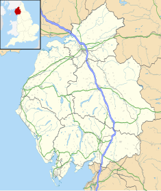
Cumbria is a ceremonial county in North West England. It borders the Scottish council areas of Dumfries and Galloway and Scottish Borders to the north, Northumberland and County Durham to the east, North Yorkshire to the south-east, Lancashire to the south, and the Irish Sea to the west. Its largest settlement is the city of Carlisle.

Ulverston is a market town and civil parish in Westmorland and Furness, Cumbria, England. Historically in Lancashire, it lies a few miles south of the Lake District National Park and just north-west of Morecambe Bay, within the Furness Peninsula. Lancaster is 39 miles (63 km) to the east, Barrow-in-Furness 10 miles (16 km) to the south-west and Kendal 25 miles (40 km) to the north-east. In the 2001 census the parish had a population of 11,524, increasing at the 2011 census to 11,678.

Westmorland is a historic county in North West England. People of the area are known as Westmerians. The area includes part of the Lake District and the southern Vale of Eden.

Kendal, once Kirkby in Kendal or Kirkby Kendal, is a market town and civil parish in the unitary authority of Westmorland and Furness, England. It lies within the River Kent's dale, from which its name is derived, just outside the boundary of the Lake District National Park.

Appleby-in-Westmorland is a market town and civil parish in Westmorland and Furness, Cumbria, England, with a population of 3,048 at the 2011 Census. Crossed by the River Eden, Appleby is the county town of the historic county of Westmorland. It was known just as Appleby until 1974–1976, when the council of the successor parish to the borough changed it to retain the name Westmorland, which was abolished as an administrative area under the Local Government Act 1972, before being revived as Westmorland and Furness in 2023. It lies 14 miles (23 km) south-east of Penrith, 32 miles (51 km) south-east of Carlisle, 27 miles (43 km) north-east of Kendal and 45 miles (72 km) west of Darlington.

Kirkby Lonsdale is a town and civil parish in the Westmorland and Furness district of Cumbria, England, on the River Lune. Historically in Westmorland, it lies 13 miles (21 km) south-east of Kendal on the A65. The parish recorded a population of 1,771 in the 2001 census, increasing to 1,843 at the 2011 Census.

Windermere is a town in the civil parish of Windermere and Bowness, in the Westmorland and Furness district in the ceremonial county of Cumbria, England; it is within the Lake District National Park. The town lies about half a mile (1 km) east of the lake, Windermere, from which it takes its name. In 2021 it had a population of 4,826.
Grange-over-Sands is a town and civil parish on the north side of Morecambe Bay in Cumbria, England, a few miles south of the Lake District National Park. In the 2011 census the parish had a population of 4,114, increasing at the 2021 census to 4,279. Within the boundaries of the historic county of Lancashire, the town became administered as an urban district in 1894. Though the town remains part of the Duchy of Lancaster, since 2023 it has been administered as part of the Westmorland and Furness Council area.

Milnthorpe is a village, civil parish, and former market town in Westmorland and Furness, Cumbria, England. It is 7 miles (11 km) south of Kendal. Historically in the county of Westmorland and on the A6, the village contains several old hostelries and hosts a market every Friday. The parish, which includes the village of Ackenthwaite, had a population of 2,199 according to the 2011 Census.

Westmorland and Lonsdale is a constituency in the south of Cumbria, represented in the House of Commons of the UK Parliament since 2005 by Tim Farron, the former leader of the Liberal Democrats (2015–2017).

South Westmorland was a rural district in Westmorland, England from 1894 to 1974. It saw various boundary changes during its existence, particularly in 1935, when it absorbed Kirkby Lonsdale urban district, whilst parts merged with Ambleside and Grasmere Urban Districts to form Lakes Urban District at the same time. The district was abolished in 1974 under the Local Government Act 1972, with the area becoming part of the South Lakeland district of Cumbria.

Kendal College is a further education college situated in Kendal on the edge of the Lake District National Park. The college provides a range of training and education programmes, including Further Education, Higher Education and training courses to support local employers, as well as more diverse work such as hospitality consultancy for Cambridge University.
Cumbria Archive Service was established to serve the English county of Cumbria. Rather than having just one county record office, Cumbria County Council operated four local record offices, now known as archive centres, in Barrow-in-Furness, Carlisle, Kendal and Whitehaven.
Barrow-in-Furness Town Hall is a Gothic Revival style municipal building in Barrow-in-Furness, Cumbria, England. The building, which served as the headquarters of the former Barrow Borough Council, and now one of the bases of Westmorland and Furness Council, lies within a Conservation Area with Grade II* listed status.

Cumbria House is a municipal building in the Botchergate area of Carlisle, England. It is used by Cumberland Council.
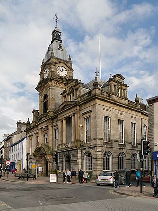
The Town Hall is a municipal building in Highgate, Kendal, Cumbria. It is a Grade II listed building. It serves as the headquarters of Kendal Town Council and also forms part of the complex of buildings which serves as the headquarters of Westmorland and Furness Council.

Westmorland County Council was the county council of Westmorland in north west England. It came into its powers on 1 April 1889 and was abolished on 1 April 1974. The county council was initially based at the Town Hall in Kendal and then, from 1939, based at the County Offices in Kendal. It was amalgamated with Cumberland County Council to form the new Cumbria County Council in 1974.

Westmorland and Furness is a unitary authority area in Cumbria, England. The economy is mainly focused on tourism around both the Lake District and Cumbria Coast, shipbuilding and the port in Barrow-in-Furness, and agriculture in the rural parts of the area.

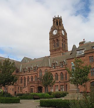
Westmorland and Furness Council is the local authority for Westmorland and Furness, a local government district in the ceremonial county of Cumbria, England. It is a unitary authority, being a district council which also performs the functions of a county council. The council has been under Liberal Democrat majority control since its creation in 2023. It has its official headquarters at the Town Hall and adjoining South Lakeland House in Kendal, with additional offices in Barrow-in-Furness and Penrith.

Ulverston Town Hall is a former municipal building on Queen Street, Ulverston, a town in Cumbria, England. The building has been converted for residential use.