
Cobh, known from 1849 until 1920 as Queenstown, is a seaport town on the south coast of County Cork, Ireland. With a population of around 13,000 inhabitants, Cobh is on the south side of Great Island in Cork Harbour and home to Ireland's only dedicated cruise terminals. Tourism in the area draws on the maritime and emigration legacy of the town.

Yarmouth Castle is an artillery fort built by Henry VIII in 1547 to protect Yarmouth Harbour on the Isle of Wight from the threat of French attack. Just under 100 feet (30 m) across, the square castle was initially equipped with 15 artillery guns and a garrison of 20 men. It featured an Italianate "arrow-head" bastion on its landward side; this was very different in style from the earlier circular bastions used in the Device Forts built by Henry and was the first of its kind to be constructed in England.

Cork Harbour is a natural harbour and river estuary at the mouth of the River Lee in County Cork, Ireland. It is one of several which lay claim to the title of "second largest natural harbour in the world by navigational area". Other contenders include Halifax Harbour in Canada, Trincomalee Harbour in Sri Lanka and Poole Harbour in England.

Great Island is an island in Cork Harbour, at the mouth of the River Lee and close to the city of Cork, Ireland. The largest town on the island is Cobh. The island's economic and social history has historically been linked to the naval, ship-building, and shipping activities in the town's environs.

Pendennis Castle is an artillery fort constructed by Henry VIII near Falmouth, Cornwall, England between 1540 and 1542. It formed part of the King's Device programme to protect against invasion from France and the Holy Roman Empire, and defended the Carrick Roads waterway at the mouth of the River Fal. The original, circular keep and gun platform was expanded at the end of the century to cope with the increasing Spanish threat, with a ring of extensive stone ramparts and bastions built around the older castle. Pendennis saw service during the English Civil War, when it was held by the Royalists, and was only taken by Parliament after a long siege in 1646. It survived the interregnum and Charles II renovated the fortress after his restoration to the throne in 1660.

Coastal artillery is the branch of the armed forces concerned with operating anti-ship artillery or fixed gun batteries in coastal fortifications.

Spike Island is an island of 103 acres (42 ha) in Cork Harbour, Ireland. Originally the site of a monastic settlement, the island is dominated by an 18th-century bastion fort now named Fort Mitchel.

Fort Manoel is a star fort on Manoel Island in Gżira, Malta. It was built in the 18th century by the Order of Saint John, during the reign of Grand Master António Manoel de Vilhena, after whom it is named. Fort Manoel is located to the north west of Valletta, and commands Marsamxett Harbour and the anchorage of Sliema Creek. The fort is an example of Baroque architecture, and it was designed with both functionality and aesthetics in mind.

Charles Fort is a trace italien fortification, a bastion fort with one section of the outer wall built in star fashion. It is located on the water's edge, at the southern end of the village of Summer Cove, on Kinsale harbour, County Cork, Ireland. First completed in 1682, Charles Fort was sometimes historically referred to as the "new fort" - to contrast with James' Fort which had been built on the other side of Kinsale harbour before 1607. The fort is now operated as a heritage tourism site by the Heritage Ireland arm of the Office of Public Works.

Fort Rodd Hill National Historic Site is a 19th-century coastal artillery fort on the Colwood, British Columbia side of Esquimalt Harbour,. The site is adjacent to Fisgard Lighthouse National Historic Site, the first lighthouse on the west coast of Canada. Both the fort and lighthouse are managed and presented to the public by Parks Canada.

Maungauika is a volcano forming a headland called North Head at the east end of the Waitematā Harbour in Auckland, New Zealand, in the suburb of Devonport. Known for its sweeping views over the harbour and the Hauraki Gulf, since 1885 the head was mainly used by the military as a coastal defence installation, which left a network of accessible old bunkers and tunnels as its legacy, forming part of the attraction. The site was protected as part of Hauraki Gulf Maritime Park in 1972 and listed as a Category I historic place in 2001. As part of a 2014 Treaty of Waitangi claim settlement the volcanic cone was officially named Maungauika and the reserve renamed Maungauika / North Head Historic Reserve. Maungauika is the Māori word for Mountain of Uika.
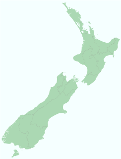
Coastal fortifications were constructed in New Zealand in two main waves: around 1885 as a response to fears of an attack by Russia, and in World War II due to fears of invasion by the Japanese.

Coastal defenceand coastal fortification are measures taken to provide protection against military attack at or near a coastline, for example, fortifications and coastal artillery. Because an invading enemy normally requires a port or harbour to sustain operations, such defences are usually concentrated around such facilities, or places where such facilities could be constructed. Coastal artillery fortifications generally followed the development of land fortifications, usually incorporating land defences; sometimes separate land defence forts were built to protect coastal forts. Through the middle 19th century, coastal forts could be bastion forts, star forts, polygonal forts, or sea forts, the first three types often with detached gun batteries called "water batteries". Coastal defence weapons throughout history were heavy naval guns or weapons based on them, often supplemented by lighter weapons. In the late 19th century separate batteries of coastal artillery replaced forts in some countries; in some areas these became widely separated geographically through the mid-20th century as weapon ranges increased. The amount of landward defence provided began to vary by country from the late 19th century; by 1900 new US forts almost totally neglected these defences. Booms were also usually part of a protected harbor's defences. In the middle 19th century underwater minefields and later controlled mines were often used, or stored in peacetime to be available in wartime. With the rise of the submarine threat at the beginning of the 20th century, anti-submarine nets were used extensively, usually added to boom defences, with major warships often being equipped with them through early World War I. In World War I railway artillery emerged and soon became part of coastal artillery in some countries; with railway artillery in coast defence some type of revolving mount had to be provided to allow tracking of fast-moving targets.

Camden Fort Meagher is a coastal defence fortification close to Crosshaven, County Cork, Ireland. Together with similar structures at Fort Mitchell, Fort Davis (Whitegate), and Templebreedy Battery, the fort was built to defend the mouth of Cork Harbour. Though originally constructed in the 16th century, the current structures of the fort date to the 1860s. Originally named Fort Camden and operated by the British Armed Forces, the fort was handed-over to the Irish Defence Forces in 1938. Renamed Fort Meagher in honour of Thomas Francis Meagher, it remained an Irish military installation until 1989 when the Irish Army handed the fort over to Cork County Council. It remained largely overgrown until 2010 when a group of local volunteers began restoration and development of the fort for heritage and tourism purposes. The fort was renamed Camden Fort Meagher and is now open seasonally to visitors, with exhibits on the fort's Brennan torpedo installation.

The fortifications of Malta consist of a number of walled cities, citadels, forts, towers, batteries, redoubts, entrenchments and pillboxes. The fortifications were built over thousands of years, from around 1450 BC to the mid-20th century, and they are a result of the Maltese islands' strategic position and natural harbours, which have made them very desirable for various powers.

Fort Davis, is a coastal defence fortification close to Whitegate, County Cork, Ireland. Together with similar structures at Fort Mitchel, Fort Camden (Crosshaven), and Templebreedy Battery, the fort was built to defend the mouth of Cork Harbour. Though used as a fortification from the early 17th century, the current structures of the 74-acre site date primarily from the 1860s. Originally named Fort Carlisle and operated by the British Armed Forces, the fort was handed-over to the Irish Defence Forces in 1938, and renamed Fort Davis. The facility is owned by the Department of Defence, and is used as a military training site with no public access.

Fort Templebreedy, also known as Templebreedy Battery, was a coastal defence fortification close to Crosshaven, in County Cork, Ireland. Supplementing a number of earlier structures at Fort Camden and Fort Davis, the site was developed between 1904 and 1909 to defend the mouth of Cork Harbour. Used as a coastal artillery position until the 1940s, and as a military training camp until the late 20th century, many of the structures of the 37-acre site were dismantled over time, and part of the complex used as a pitch and putt course. In 2009, Cork County Council added the site to a proposed list of protected structures – though as of 2020 it remains in the ownership of the Department of Defence.

The fortifications of Plymouth in Devon are extensive due to its natural harbour, its commanding position on the Western Approaches and its role as the United Kingdom's second largest naval base after Portsmouth. The first medieval defences were built to defend Sutton Harbour on the eastern side of Plymouth Sound at the mouth of the River Plym, but by the 18th century, naval activity had begun to shift westward to Devonport at the mouth of the River Tamar. During the Victorian era, advances in military technology led to a huge programme of fortification encompassing the whole of Plymouth Sound together with the overland approaches. Many of these works remained in military use well into the 20th century.
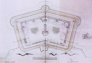
A polygonal fort is a type of fortification originating in France in the late 18th century and fully developed in Germany in the first half of the 19th century. Unlike earlier forts, polygonal forts had no bastions, which had proved to be vulnerable. As part of ring fortresses, polygonal forts were generally arranged in a ring around the place they were intended to protect, so that each fort could support its neighbours. The concept of the polygonal fort proved to be adaptable to improvements in the artillery which might be used against them, and they continued to be built and rebuilt well into the 20th century.


