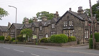
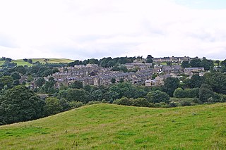
It is situated between Fixby and Birkby based around Cowcliffe Hill Road. Cowcliffe is a discernible village, though the boundaries are not clear and is somewhat isolated from the rest of Huddersfield – only two buses an hour go through the area, destined for either Halifax and Huddersfield (First Halifax services 549).
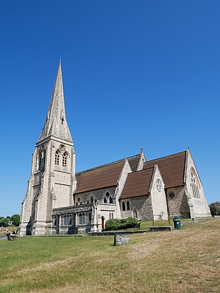
The area is home to a pub, St. Hilda's Parish Church, Cowcliffe Methodist Church, a shop, a park and a club with bowling green.. At the west border of the area is Huddersfield Golf Club, to the north is Fixby (the golf course is known locally as Fixby Golf Course), to the south and east are Birkby and Fartown.
The ITV drama series Where The Heart Is shot a small number scenes in Cowcliffe's park in 2002, not long after the park had had a facelift from Kirklees Metropolitan Council, who installed goalposts and a designated play area.
At the top of North Cross Rd, a large house known locally as the Castle was renovated from a derelict state in the mid 1980s by a local developer and an 3 home estate built on the former gardens and the properties named after Castle features.
Cowcliffe Hill Road was once the main coach road from London to Gretna Green.
Blackheath is an area in Southeast London, straddling the border of the Royal Borough of Greenwich and the London Borough of Lewisham. Historically within the county of Kent, it is located 1-mile (1.6 km) northeast of Lewisham, 1.5 miles (2.4 km) south of Greenwich and 6.4 miles (10.3 km) southeast of Charing Cross, the traditional centre of London.
West Yorkshire is a metropolitan and ceremonial county in the Yorkshire and the Humber region of England. It borders North Yorkshire to the north and east, South Yorkshire and Derbyshire to the south, Greater Manchester to the south-west, and Lancashire to the west. The city of Leeds is the largest settlement.
Brighouse is a town within the metropolitan borough of Calderdale, in West Yorkshire, England. Historically within the West Riding of Yorkshire, it is situated on the River Calder, 4 miles (6.4 km) east of Halifax. It is served by Junction 25 of the M62 motorway and Brighouse railway station on the Caldervale Line and Huddersfield Line. In the town centre is a mooring basin on the Calder and Hebble Navigation. The United Kingdom Census 2001 gave the Brighouse / Rastrick subdivision of the West Yorkshire Urban Area a population of 32,360. The Brighouse ward of Calderdale Council gave a population of 11,195 at the 2011 Census. Brighouse has a HD6 postcode.
Rastrick is a village in the county of West Yorkshire, England, between Halifax, 5 miles (8 km) north-west and Huddersfield, 4 miles (7 km) south.
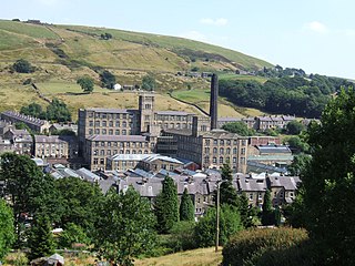
Marsden is a large village in the Colne Valley, in the metropolitan borough of Kirklees, West Yorkshire, England. It is in the South Pennines close to the Peak District which lies to the south. The village is 7 miles (11 km) west of Huddersfield at the confluence of the River Colne and Wessenden Brook. It was an important centre for the production of woollen cloth. In 2020, the village had an estimated population of 3,768.
Huddersfield is a town in the Metropolitan Borough of Kirklees in West Yorkshire, England. It is the administrative centre and largest settlement in the Kirklees district. The town is in the foothills of the Pennines. The River Holme's confluence into the similar-sized Colne is to the south of the town centre which then flows into the Calder in the north eastern outskirts of the town.
Castletown is a town in the Isle of Man, geographically within the historical parish of Malew but administered separately. Lying at the south of the island, it was the Manx capital until 1869. The centre of town is dominated by Castle Rushen, a well-preserved medieval castle, originally built for a Viking king.
Eltham is a district of southeast London, England, within the Royal Borough of Greenwich. It is 8.7 miles (14.0 km) east-southeast of Charing Cross, and is identified in the London Plan as one of 35 major centres in Greater London. The three wards of Eltham North, South and West have a total population of 35,459. 88,000 people live in Eltham.
Castle Bromwich is a large suburban village and civil parish in the Metropolitan Borough of Solihull in the West Midlands, England. It borders the rest of the borough to the south east, Sutton Coldfield to the east and north east, Shard End to the south west, Castle Vale, Erdington and Minworth to the north and Hodge Hill to the west.
Birkby is a large multi-cultural suburb close to the town centre in Huddersfield, in the Kirklees borough of West Yorkshire, England. It has a population of 6,700.
Ruchill is a district in the city of Glasgow, Scotland. It lies within the Canal Ward of north Glasgow in the Ruchill Community Council area between the Maryhill and Possilpark and North Kelvinside areas of the city.
Lightcliffe is a village in the Calderdale district in West Yorkshire, England. Historically part of the West Riding of Yorkshire, it is situated approximately three miles east of Halifax and two miles north west of Brighouse. Lightcliffe was a separate parish in 1846 in the West Riding of Yorkshire.
Humber Valley Village is a neighbourhood located in Toronto, Ontario, Canada. It is within the former suburb of Etobicoke and includes some of the most expensive real estate in the metropolitan west end. The boundaries are from Dundas Street on the south to Islington Avenue to the west, Eglinton Avenue to the north, and the Humber River in the east. The neighbourhood is in the political riding of Etobicoke Centre.
Fixby is a suburb in north-west Kirklees bordering neighbouring Calderdale and is traditionally part of Huddersfield in the county of West Yorkshire, England.
Halifax is a town in the Metropolitan Borough of Calderdale, in West Yorkshire, England. It is in the eastern foothills of the Pennines. In the 15th century, the town became an economic hub of the old West Riding of Yorkshire, primarily in woollen manufacture with the large Piece Hall square later built for trading wool in the town centre. The town was a thriving mill town during the Industrial Revolution with the Dean Clough Mill buildings a surviving landmark. In 2021, it had a population of 88,109. It is also the administrative centre of the wider Calderdale Metropolitan Borough.
Holywell Green is a village in the civil parish of Stainland and District, in the Calderdale, district, in the county of West Yorkshire, England. The village is situated approximately 1.4 miles (2 km) south-west of Elland, 3.3 miles (5 km) south of Halifax and 3.9 miles (6 km) north-west of Huddersfield. Holywell Green is part of the Greetland and Stainland Ward of Calderdale Council.
Edgerton is a suburb of the town of Huddersfield in West Yorkshire, England. The suburb is located along the A629 road, also known as Edgerton Road, from Huddersfield to Halifax. It is some 1 mile (1.6 km) west of the town centre. It is the location of many of the towns largest and most imposing houses, as well as the town's principal cemetery.
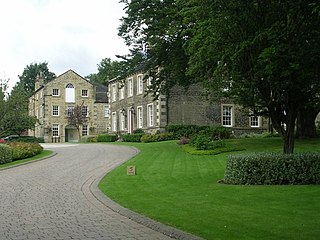
Ashbrow is a ward of Huddersfield in the metropolitan borough of Kirklees, West Yorkshire, England. It contains 50 listed buildings that are recorded in the National Heritage List for England. Of these, one is listed at Grade II*, the middle of the three grades, and the others are at Grade II, the lowest grade. The ward is to the north of the centre of Huddersfield, and includes the districts of Ashbrow, Brackenhall, Bradley, Deighton, Fixby, Netheroyd Hill, and Sheepridge. The southern part of the ward is suburban and residential, and to the north is some parkland and countryside. The Huddersfield Broad Canal and the Kirklees Cut of the Calder and Hebble Navigation originate in the ward, and the River Calder passes through it; the listed buildings associated with these waterways include locks, bridges, a floodgate, a canal milestone, and a lock keeper's cottage. The former country house, Fixby Hall, later a golf clubhouse, is in the northwest part of the ward; this is listed, together with associated structures and the lodges at the entrances to its park. The other listed buildings include houses, cottages, and associated structures, farmhouses and farm buildings, another country house, churches and items in churchyards, the parapet of a ford, a road milestone, and two railway bridges.
Greenhead is a ward of Huddersfield in the metropolitan borough of Kirklees, West Yorkshire, England. It contains 258 listed buildings that are recorded in the National Heritage List for England. Of these, four are listed at Grade II*, the middle of the three grades, and the others are at Grade II, the lowest grade. The ward is to the west and north of the centre of town of Huddersfield, it is mainly residential, and includes the districts and suburbs of Birkby, Edgerton, Fartown, Gledholt, Highfields, Hillhouse, Longwood, Marsh, Paddock, and Thornton Lodge.
This page is based on this Wikipedia article Text is available under the CC BY-SA 4.0 license; additional terms may apply. Images, videos and audio are available under their respective licenses.