
The coyote is a species of canine native to North America. It is smaller than its close relative, the wolf, and slightly smaller than the closely related eastern wolf and red wolf. It fills much of the same ecological niche as the golden jackal does in Eurasia. The coyote is larger and more predatory, and was once referred to as the American jackal by a behavioral ecologist. Other historical names for the species include the prairie wolf and the brush wolf.

The Arizona Coyotes are a professional ice hockey team based in the Phoenix metropolitan area. The Coyotes compete in the National Hockey League (NHL) as a member of the West Division. The team first played at America West Arena in downtown Phoenix, before moving to Glendale's Gila River Arena in 2003. Starting in the 2021–22 NHL season, the Coyotes are scheduled to return to the Central Division for the first time since the 1997-98 season when the Seattle Kraken joins the league.

Wile E. Coyote and the Road Runner are a duo of cartoon characters from the Looney Tunes and Merrie Melodies series of cartoons. In each episode, the cunning, insidious and constantly hungry Coyote repeatedly attempts to catch and subsequently eat the Road Runner, a fast-running ground bird, but is successful the Road Runner only on one occasion. Instead of his animal instincts, the Coyote uses absurdly complex contraptions to try to catch his prey, which comically backfire, with the Coyote often getting injured in slapstick fashion. Many of the items for these contrivances are mail-ordered from a variety of companies that are all named Acme.

Morgan Hill is a city in Santa Clara County, California, at the southern tip of Silicon Valley, in the San Francisco Bay Area. Morgan Hill is a residential community for Silicon Valley, as well as the seat of several high-tech companies. Morgan Hill is a dining, entertainment, and recreational destination in Silicon Valley, owing to its Michelin-star chefs, luxury hospitality, wineries, nature parks, and events the city hosts, such as the Tour of California. According to Forbes, Morgan Hill is one of the most expensive places to live in the United States. Business Insider ranked Morgan Hill as the 17th most expensive housing market in the United States, owing to its concentration of high-net-worth individuals and restrictive growth policies.

Gila River Arena is a sports and entertainment arena at the Westgate Entertainment District in Glendale, Arizona.

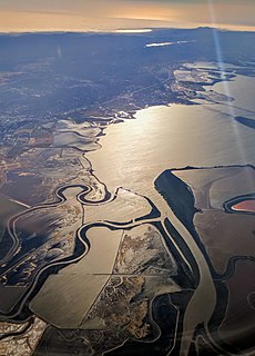
Coyote Valley is a large expanse of farmland, orchards and homes, approximately 7,400 acres (2,995 ha) in size, located in a narrowing of the Santa Clara Valley, in the southernmost part of San Jose, California. The Coyote Valley is targeted for urban development and until March 2008 was undergoing the State of California Specific Plan process in which master planning of the area began. The process was intended to analyze the feasibility of bringing new development to the area, with the participation of planners, environmentalists, engineers, and the general public. Although the North and the Mid-Coyote Valley areas have been planned for urban development since 1961, much controversy surrounds the proposal to build in this valley, which is considered by many to be the last remaining "untouched" open area within San Jose, an open space buffer between the urban City of San Jose and the northward expanding City of Morgan Hill. The Coyote Gap at the extreme north end of Coyote Valley is a critical wildlife corridor for safe passage of large and small mammals from the Diablo Range to the Santa Cruz Mountains because it is the narrowest point between the two mountain ranges.

Coyote Hills Regional Park is a regional park encompassing nearly 978 acres of land and administered by the East Bay Regional Park District. The park, which was dedicated to public use in 1967, is located in Fremont, California, USA, on the southeast shore of the San Francisco Bay. The Coyote Hills themselves are a small range of hills at the edge of the bay; though not reaching any great height, they afford tremendous views of the bay, three of the trans-bay bridges, the cities of San Francisco and Oakland, the Peninsula Range of the Santa Cruz Mountains and Mount Tamalpais. In addition to the hills themselves, the park encloses a substantial area of wetlands.
Coyote Creek is a river that flows through the Santa Clara Valley in California, United States.

Guided Muscle is a 1955 Warner Bros. Looney Tunes cartoon directed by Chuck Jones. The short was released on December 10, 1955, and stars Wile E. Coyote and the Road Runner.

There They Go-Go-Go! is a 1956 Warner Bros. Looney Tunes cartoon directed by Chuck Jones. The short was released on November 10, 1956, and stars Wile E. Coyote and the Road Runner.

Coyote is an unincorporated community in a narrowing of Santa Clara Valley astride Coyote Creek, between San Jose and Morgan Hill's Madrone district, in Santa Clara County, California. Part of Coyote is inside the city limits of San Jose. Its ZIP Code is 95013; there is a small U.S. Post Office. It is inside telephone area codes 408 and 669.

Coyote Lake is an artificial lake in Santa Clara County, California, between Morgan Hill and Gilroy.

The East Coyote Hills are a low mountain range in northern Orange County, California, mostly in the cities of Fullerton and Placentia.
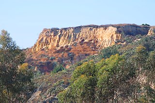
The West Coyote Hills are a low mountain range in northern Orange County, California. It contains one of the last large open-space area in north Orange County. Parts of it lie within the city limits of La Habra, Buena Park, and La Mirada, with most of it sprawling across western Fullerton between Ralph B. Clark Regional Park and Euclid Street north of Rosecrans Avenue. The foothill region to the east and south is known as Sunny Hills. There is also an East Coyote Hills area, on the east side of Fullerton, that has been almost completely developed for residential real estate.

Anderson Lake, also known as Anderson Reservoir, is an artificial lake in Santa Clara County, California, United States, near Morgan Hill. The reservoir is formed by the damming of Coyote Creek just below its confluence with Las Animas Creek. A 4,275-acre (1,730 ha) county park surrounds the reservoir and provides limited fishing, picnicking, and hiking activities. Although swimming is prohibited, boating, water-skiing and jet-skiing are permitted in the reservoir.

Coyote Creek is a principal tributary of the San Gabriel River in northwest Orange County, southeast Los Angeles County, and southwest Riverside County, California. It drains a land area of roughly 41.3 square miles (107 km2) covering five major cities, including Brea, Buena Park, Fullerton, La Habra, and La Palma. Some major tributaries of the creek in the highly urbanized watershed include Brea Creek, Fullerton Creek, and Carbon Creek. The mostly flat creek basin is separated by a series of low mountains, and is bounded by several small mountain ranges, including the Chino Hills, Puente Hills and West Coyote Hills.

The 5,080-acre (20.6 km2) Coyote Mountains Wilderness of Arizona is part of the Coyote Mountains of southern Arizona in the center of Pima County. The wilderness lies about 40 mi southwest of Tucson, in the northwest of the Altar Valley. Kitt Peak is 4 mi WSW.

The Get Lucky Tour was a 2010 concert tour by British singer-songwriter and guitarist Mark Knopfler, promoting the release of his album Get Lucky. The tour consisted of two legs: North America and Europe. The North American leg started on 8 April 2010 in Seattle, Washington, and included 28 concerts in 27 cities, ending on 9 May 2010 in Albany, New York. The European leg started on 9 September 2010 in London, and included 59 concerts in 51 cities, ending on 31 July 2010 in Ávila, Spain. The tour included a six-night run at the Royal Albert Hall in London.

The Tucson Roadrunners are a professional ice hockey team in the American Hockey League (AHL) that began play for the 2016–17 season. Based in Tucson, Arizona, and affiliated with the National Hockey League's Arizona Coyotes, the team plays its home games at the Tucson Convention Center.
Adin Hill is a Canadian professional ice hockey goaltender currently playing for the Arizona Coyotes of the National Hockey League (NHL). Hill was selected by the Coyotes, 76th overall, in the 2015 NHL Entry Draft.

