Glacier National Park is an American national park located in northwestern Montana, on the Canada–United States border, adjacent to the Canadian provinces of Alberta and British Columbia. The park encompasses over 1 million acres (4,000 km2) and includes parts of two mountain ranges, over 130 named lakes, more than 1,000 different species of plants, and hundreds of species of animals. This vast pristine ecosystem is the centerpiece of what has been referred to as the "Crown of the Continent Ecosystem," a region of protected land encompassing 16,000 square miles (41,000 km2).

The Lewis Range is a mountain range located in the Rocky Mountains of northern Montana, United States and extreme southern Alberta, Canada. It was formed as a result of the Lewis Overthrust, a geologic thrust fault resulted in the overlying of younger Cretaceous rocks by older Proterozoic rocks. The range is located within Waterton Lakes National Park in Alberta, Canada and Glacier National Park and the Bob Marshall Wilderness Complex in Montana, United States. The highest peak is Mount Cleveland at 10,466 ft (3,190 m).

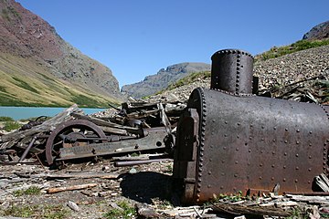
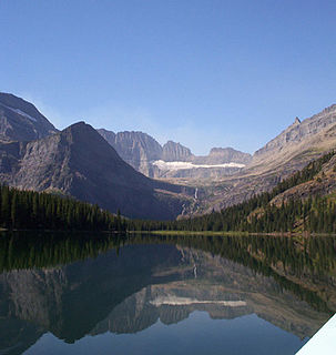
Many Glacier is an area within Glacier National Park which is located in the U.S. state of Montana. The Many Glacier region is located north of the Going-to-the-Sun Road, on the east side of the park. Lake Sherburne is the large lake in the area and the Many Glacier Hotel, the largest hotel within the park, is along the shore of the adjacent Swiftcurrent Lake. The Many Glacier Hotel and surrounding buildings are a National Historic Landmark, with original construction dating back to 1915. Many Glacier is surrounded by the high peaks of the Lewis Range, and numerous hiking trails can be accessed from the area. The region is noted for numerous lakes, waterfalls and dense coniferous forests interspersed with alpine meadows. Major sites in the immediate vicinity that can be accessed by trails include Lake Josephine, Grinnell Lake, Grinnell Glacier, Cracker Lake, Granite Park Chalet, Iceberg Cirque and the Ptarmigan Tunnel, which is a hiking tunnel carved through the mountainside during the 1930s. Tour boats allow visitors an opportunity to venture onto Swiftcurrent Lake. Other activities in the region include ranger guided nature hikes, horseback riding, fishing and camping.

Mount Siyeh, with a height of 10,019 feet (3,054 m), is the fifth tallest and one of six peaks over 10,000 feet (3,048 m) in Glacier National Park, Montana, United States. Mount Siyeh was named after a Blackfeet Indian, Sai-yeh, whose name means "Crazy Dog" or "Mad Wolf."

Babb is a small unincorporated farming and ranching community in Glacier County, Montana, United States, on the Blackfeet Indian Reservation. The community experiences a large influx of tourists in the summer months as it is the gateway to the Many Glacier area of Glacier National Park. Babb is a census-designated place (CDP) and had a population of 174 at the 2010 census.

The following articles relate to the history, geography, geology, flora, fauna, structures and recreation in Glacier National Park (U.S.), the U.S. portion of the Waterton-Glacier International Peace Park.
Cracker benchmark is located in the Lewis Range, Glacier National Park in the U.S. state of Montana. Cracker is a benchmark summit located on a ridgeline 0.5 miles (1 km) northeast of Mount Siyeh.

Cobalt Lake is located in Glacier National Park, in the U. S. state of Montana. The lake is just east of the Continental Divide in the Two Medicine region of Glacier National Park. Cobalt Lake is a 5.7-mile (9.2 km) hike from the Two Medicine Store.
Upper Two Medicine Lake is located in Glacier National Park, in the U. S. state of Montana. The lake is just east of the Continental Divide in the Two Medicine region of Glacier National Park. Upper Two Medicine Lake is in a cirque and surrounded by a number of peaks including Lone Walker Mountain, Mount Helen and Pumpelly Pillar. Upper Two Medicine Lake is a 5 miles (8.0 km) hike from the Two Medicine Store.

Oldman Lake is located in Glacier National Park, in the U. S. state of Montana. Oldman Lake is immediately east of Mount Morgan and north of Flinsch Peak. Oldman Lake is a 5.7-mile (9.2 km) hike from the Two Medicine Store.
Red Eagle Lake is located in Glacier National Park, in the U. S. state of Montana. Red Eagle Mountain rises to the west of the lake and Saint Mary Lake is to the north. Red Eagle Lake is accessible from the Triple Divide Trail and is a 7.6 miles (12.2 km) hike from St. Mary, Montana.
Otokomi Lake is located in Glacier National Park, in the U. S. state of Montana. Otokomi Lake is in a cirque north of Goat Mountain. The lake is a 5.2 miles (8.4 km) hike by trail from the Rising Sun Auto Camp.
Lake Josephine is located in Glacier National Park, in the U. S. state of Montana. Swiftcurrent Lake is immediately to the northeast of Lake Josephine and the two lakes are separated by a short stream. Lake Josephine is accessible via the Grinnell Glacier Trail which follows the west shoreline of the lake for 1 mile (1.6 km).

Upper Grinnell Lake is located in Glacier National Park, in the U. S. state of Montana. Upper Grinnell Lake is a proglacial lake which formed in the 1930s as Grinnell Glacier retreated. The lake is often filled with small icebergs which have been breaking off Grinnell Glacier. Upper Grinnell Lake can be reached by trail and is a 5.5 miles (8.9 km) hike from the Many Glacier Hotel.
Kennedy Lake is located in Glacier National Park, in the U. S. state of Montana. The lake is in a cirque with Mount Henkel to the south and Crowfeet Mountain to the northwest. The Redgap Pass Trail is the closest maintained trail but does not go to this remote lake.

Iceberg Lake is located in Glacier National Park, in the U. S. state of Montana. Mount Wilbur is south and Iceberg Peak is west of Iceberg Lake. Iceberg Peak towers more than 3,000 feet (910 m) above the lake. A popular day hike destination, Iceberg Lake is a 4.8 miles (7.7 km) hike from the Swiftcurrent Auto Camp Historic District.
Ptarmigan Lake is located in Glacier National Park, in the U. S. state of Montana. Ptarmigan Lake is situated below the Ptarmigan Wall. The lake is a 4.3 miles (6.9 km) hike from the Swiftcurrent Auto Camp Historic District by way of the Ptarmigan Trail. After another .9 miles (1.4 km) hike from Ptarmigan Lake, the historic Ptarmigan Tunnel can be seen.

Hidden Lake is located in Glacier National Park, in the U. S. state of Montana.

Logging Lake is located in Glacier National Park, in the U. S. state of Montana. Logging Lake is one of the longest lakes in Glacier National Park at 6 miles (10 km) in length. The Lower Logging Lake Snowshoe Cabin and Boathouse are two structures located near the southwestern end of Logging Lake, and are on the National Register of Historic Places. Logging Lake is a 4.5 miles (7.2 km) hike from the Logging Lake Ranger Station.
Quartz Lake is located in Glacier National Park, in the U. S. state of Montana. Quartz Lake is only 150 yards (140 m) east of Middle Quartz Lake. Quartz Lake is a 6 miles (9.7 km) hike from the Bowman Lake Picnic Area. The historic Quartz Lake Patrol Cabin is on the western shore of Quartz Lake.