
The River Taff is a river in Wales. It rises as two rivers in the Brecon Beacons; the Taf Fechan and the Taf Fawr before becoming one just north of Merthyr Tydfil. Its confluence with the River Severn estuary is in Cardiff.

The Alwen Reservoir is a 5 kilometres (3 mi) long reservoir near Pentre-Llyn-Cymmer in Conwy County Borough, Wales.

Fishkill Creek is a tributary of the Hudson River in Dutchess County, New York, United States. At 33.5 miles (53.9 km) it is the second longest stream in the county, after Wappinger Creek. It rises in the town of Union Vale and flows generally southwest to a small estuary on the Hudson just south of Beacon. Part of its 193-square-mile (500 km2) watershed is in Putnam County to the south. Sprout Creek, the county's third-longest creek, is its most significant tributary. Whaley and Sylvan lakes and Beacon Reservoir, its largest, deepest and highest lakes, are among the bodies of water within the watershed.
The Usk Reservoir is located in the upper Usk Valley, at 1,006 feet (307 m) above sea level, in the western part of the Brecon Beacons National Park, Wales. The county boundary between Carmarthenshire and Powys runs through the reservoir which lies about six miles to the north of the Black Mountain escarpment. It is an important landmark for walkers on the mountain range.

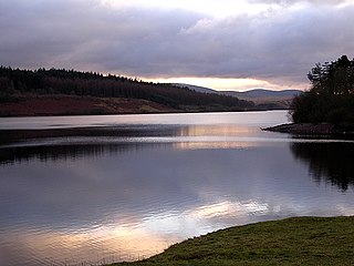
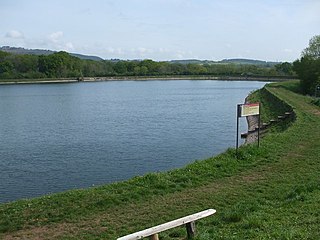
Beacons Reservoir is the northernmost of the three reservoirs in the Taff Fawr valley in South Wales. It was built by Cardiff Corporation Waterworks between 1893 and 1897, and the water is impounded by an earth dam with a clay core. Since 1973 it has been owned by Welsh Water. As its name suggests, it is located in the Brecon Beacons National Park in the Powys unitary authority area and within the historic county boundaries of Breconshire.

Cantref Reservoir is the middle of the three reservoirs in the Taff Fawr valley in Wales. It was built by Cardiff Corporation Waterworks between 1886 and 1892, but since 1973 has been owned by Welsh Water. It is located in the Brecon Beacons National Park, mostly in the Powys unitary authority area and within the historic county boundaries of Breconshire. Part of the south west corner is in the Rhondda Cynon Taff unitary authority area.

Rocky Creek Dam is a minor rock fill clay core embankment dam across the Rocky Creek, located upstream of Lismore in the Northern Rivers region of New South Wales, Australia. The dam's main purpose is to supply potable water for the region, including Lismore, Ballina, Byron Bay, Evans Head and Alstonville. The impounded reservoir is called Rocky Lake.

Fforest Fawr is an extensive upland area in the county of Powys, Wales. Formerly known as the Great Forest of Brecknock in English, it was a royal hunting area for several centuries but is now used primarily for sheep grazing, forestry, water catchment and recreation. It lies within the Brecon Beacons National Park.

Ystradfellte Reservoir is a water storage reservoir on the Afon Dringarth in the upland area of Fforest Fawr within the Brecon Beacons National Park in South Wales. It lies just north of the village of Ystradfellte in the county of Powys at OS Grid ref SN 946178.

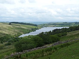
The Afon Crai is a river in Powys, Wales rising in the Fforest Fawr section of the Brecon Beacons National Park and flowing north into the River Usk. The headwaters known as Blaen-crai flow north from Bwlch Bryn-rhudd, a col between the Crai valley and the upper Swansea Valley for 2 km into the Cray Reservoir. The river emerges from below the dam to flow a further 8 km through the dispersed settlement of Crai.
Crai is a village in the Brecon Beacons National Park in the county of Powys, Wales and the historic county of Breconshire. The population of Cray community at the 2011 census was 241. Within the community are the hamlet of Felin-Crai and many dispersed farms around the valley of the Afon Crai. The river is dammed 2 km / 1.5 mi southwest of the village to form Cray Reservoir. Crai means fresh, raw water. The famous Llywel Stone was found close to the Crai/Trecastle boundary. A history of the village is contained in Lewis, D. Craionog: Hanes plwyf Defynog : yn cynnwys y rhanbarthau cynlynol; Crai, Glyntawy, Senni, Glyntarell, a Maescar. Merthyr Tydfil : H. W. Southey a'i Feibion, Cyf, Argrffwyr, 1911.

Waun Lefrith is a top of Picws Du and is also the westernmost of the Carmarthen Fans or Bannau Sir Gaer, a group of peaks within the Black Mountain of the Brecon Beacons National Park. It lies within Carmarthenshire, Wales. The summit plateau of the mountain reaches a height of 2221 feet above sea level. Picws Du and Fan Foel are the other, higher summits of the Bannau Sir Gaer / Carmarthen Fans. The glacial lake of Llyn y Fan Fach dominates the panorama to the north of the peak. Beyond the lake to the north lies the Usk Reservoir and then the Cambrian Mountains on the horizon. Swansea Bay and the Bristol Channel are visible to the south across the undulating dip slope of the mountain. The Tywi valley lies to the west, with Llandovery and Llandeilo as important market towns nearest to the hills.

Picws Du is the second highest peak of the Carmarthen Fans in the Carmarthenshire section of the Black Mountain in the west of the Brecon Beacons National Park in south Wales. The highest peak is Fan Foel immediately next along the ridge and it is a subsidiary summit of Fan Brycheiniog. Picws Du falls within Fforest Fawr Geopark and its prominent summit is marked by a large Bronze Age round barrow at a height of 2457 feet above sea level. Waun Lefrith is the other, lower summit of the Bannau Sir Gâr / Carmarthen Fans situated to the west. The peak overlooks the glacial lake of Llyn y Fan Fach in the cwm below. As the peak sits on the edge of the escarpment on a ridge which juts out into the valley below, the views from the summit are panoramic and extensive. The views to the north are especially impressive when the weather is clear, looking towards the Cambrian Mountains, Mynydd Epynt and Brecon. Swansea and the Bristol Channel can just be seen on the horizon to the south, across the gently falling dip slope. Pen y Fan and Corn Du are distinctive landmarks seen directly to the east across Fforest Fawr.
Cefn Cul is a hill in the Fforest Fawr sector of the Brecon Beacons National Park in Powys, southern Wales. It is a broad north-northeast to south-southwest aligned ridge whose summit reaches a height of 562 m above sea level. The hill is bounded to the west by the upper valley of the River Tawe though which the old Trecastle road runs whilst to the east is the pass of Bwlch Bryn-rhudd over which the A4067 road runs from the Crai valley south to that of the Tawe.

Glasfynydd Forest is an extensive area of coniferous plantations in the west of the Brecon Beacons National Park in Wales. It straddles the border between the counties of Powys and Carmarthenshire.

Pontsticill Reservoir or Taf Fechan Reservoir is a large reservoir on the Taf Fechan lying partly in the county of Powys and partly within the county borough of Merthyr Tydfil in south Wales. It lies within the Brecon Beacons National Park and Fforest Fawr Geopark.

The Manly Dam is a heritage-listed dam near King Street, Manly Vale with a reservoir extending into Allambie Heights, both in the Northern Beaches Council local government area of New South Wales, Australia. It is often used as a place to have recreational activities. The reservoir is located within the Manly Dam Reserve. The dam was designed by the NSW Department of Public Works and built in 1892 by the Department. The reservoir and dam is owned by Sydney Water, an agency of the Government of New South Wales. The reservoir and dam was added to the New South Wales State Heritage Register on 18 November 1999.
The Grwyne Fawr Reservoir is located in the valley of the river Grwyne Fawr in the Brecon Beacons National Park, Wales. Completed in 1928, it has the capacity to hold 400,000,000 imperial gallons.
Cardiff Corporation Waterworks, its predecessors and successors have provided a public water supply and sewerage and sewage treatment services to the Welsh city of Cardiff since 1850.
There are a large number of reservoirs in Wales reflecting the need for the supply of water for both industry and for consumption, both within the country itself and in neighbouring England. A number also provide hydroelectricity and many old reservoirs also provided motive power for industries, especially for the processing of minerals such as metal ores and slate.

 Plaque
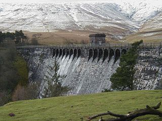
 Face of the dam
