
The Saskatchewan River is a major river in Canada. It stretches about 550 kilometres (340 mi) from where it is formed by the joining of the North Saskatchewan River and South Saskatchewan River just east of Prince Albert, Saskatchewan. It flows roughly eastward across Saskatchewan and Manitoba to empty into Lake Winnipeg. Through its tributaries the North Saskatchewan and South Saskatchewan, its watershed encompasses much of the prairie regions of Canada, stretching westward to the Rocky Mountains in Alberta and north-western Montana in the United States.

Alberta is one of the thirteen provinces and territories of Canada. Located in Western Canada, the province has an area of 661,190 km2 (255,290 sq mi) and is bounded to the south by the United States state of Montana along 49° north for 298 km (185 mi); to the east at 110° west by the province of Saskatchewan for 1,223 km (760 mi); and at 60° north the Northwest Territories for 644 km (400 mi). The southern half of the province borders British Columbia along the Continental Divide of the Americas on the peaks of the Rocky Mountains, while the northern half borders British Columbia along the 120th meridian west. Along with Saskatchewan it is one of only two landlocked provinces or territories.

The Churchill River is a major river in Saskatchewan and Manitoba, Canada. From the head of the Churchill Lake it is 1,609 kilometres (1,000 mi) long. It was named after John Churchill, 1st Duke of Marlborough and governor of the Hudson's Bay Company from 1685 to 1691. The Cree name for the river is Missinipi, meaning "big waters". The Denesuline name for the river is des nëdhë́, meaning "Great River".
The Fond du Lac River is one of the upper branches of the Mackenzie River system, draining into the Arctic Ocean, located in northern Saskatchewan, Canada. The river is 277 kilometres (172 mi) long, has a watershed of 66,800 km2 (25,800 sq mi), and its mean discharge is 300 m3/s (11,000 cu ft/s).
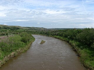
Battle River is a river in central Alberta and western Saskatchewan, Canada. It is a major tributary of the North Saskatchewan River.

The Wapiti River is a river in eastern British Columbia and western Alberta, Canada. It is a major tributary of the Smoky River, located in the southern area of the Peace River Basin.

Carrot River is a river in Western Canada in the north-eastern part Saskatchewan and the north-western part of Manitoba. The outlet of Wakaw Lake in Saskatchewan marks the beginning of the Carrot River and, from there, it flows north-east past several communities and Indian reserves until it joins the Saskatchewan River in the Cumberland Delta in Manitoba. The river's mouth is west and upstream of the Pasquia River and The Pas on the Saskatchewan River.

Athabasca Sand Dunes Provincial Park was created to protect the Athabasca sand dunes, a unique boreal shield ecosystem located in the far-northwest part of the Northern Saskatchewan Administration District. The Athabasca sand dunes are one of the most northerly active sand dune formations on Earth.

Black Lake is a Denesuline First Nations band government in the boreal forest of northern Saskatchewan, Canada. It is located on the northwest shore of Black Lake where the Fond du Lac River leaves the lake to flow to Lake Athabasca.

Cree Lake is a lake in the Canadian province of Saskatchewan. The lake is the fourth largest in the province and is located west of Reindeer Lake and south of Lake Athabasca in the Mackenzie River drainage basin. There is no highway access, but the lake is reachable by floatplane.

Black Lake is a lake in the Mackenzie River drainage basin in northern Saskatchewan, Canada. It is about 55 kilometres (34 mi) long, 17 kilometres (11 mi) wide, has an area of 464 km2 (179 sq mi), and lies at an elevation of 281 metres (922 ft). The primary inflows are the Chipman River, Cree River, Fond du Lac River, and Souter River; the primary outflow is Fond du Lac River, which flows via the Mackenzie River into the Arctic Ocean.

Waterhen River is an east-flowing river in the north-west area of the Canadian province of Saskatchewan in the drainage basin of the Beaver River. It is north of and parallel to the east-flowing part of the Beaver River and joins the north-flowing part of that river. Most of the river and its drainage basin is at the southern edge of the boreal forest belt. While the river's source is Lac des Îles, its drainage basin reaches north into the Mostoos Hills and west well into the neighbouring province of Alberta.

The La Loche River is a small river in north-west Saskatchewan. The distance from its source at the south east end of Lac La Loche to its mouth at the north end of Peter Pond Lake is 56 km. The river is bridged by Highway 956 about 5 kilometres from its source. The Kimowin River flows in from the west.

Lake Athapapuskow is a glacial lake in Manitoba and Saskatchewan, Canada, located 15 kilometres (9.3 mi) southeast of Flin Flon, Manitoba. The lake is in the Hudson Bay drainage basin and is the source of the Goose River.

Geikie River is a river in the northern part of the Canadian province of Saskatchewan. The river's source is Costigan Lake, which is near the uranium producing areas around the Key Lake mine in the Athabasca Basin. It flows in a north-easterly direction and flows into Wollaston Lake.

The Cochrane River is a river in Canadian provinces of Manitoba and Saskatchewan. Located in the boreal forest of the Canadian Shield, it flows from Wellbelove Bay on the northern end of Wollaston Lake in north-eastern Saskatchewan to the north-east end of Reindeer Lake in Manitoba. The river has a drainage basin of 28,400 square kilometres (11,000 sq mi) and is part of the Churchill River drainage basin.

Pipestone Creek is a river in the Souris River watershed. Its flow begins in southeastern Saskatchewan, just south of the town of Grenfell and travels in a southeastern direction into Manitoba in the Westman Region where it empties into Oak Lake through the Oak Lake Marsh.

