Lee County is the westernmost county in the U.S. Commonwealth of Virginia. As of the 2020 census, the population was 22,173. Its county seat is Jonesville.

Whitley County is a county located in the southeastern part of the U.S. state of Kentucky. As of the 2020 census, the population was 36,712. Its county seat is at Williamsburg, though the largest city is Corbin, and the county's District Court sits in both cities. Whitley County is included in the London, KY Micropolitan Statistical Area.

Russell County is a county located in the U.S. Commonwealth of Kentucky. As of the 2020 census, the population was 17,991. Its county seat is Jamestown and its largest city is Russell Springs. The county was formed on December 14, 1825, from portions of Adair, Cumberland and Wayne Counties and is named for William Russell.

Cumberland County is a county located in the Pennyroyal Plateau region of the U.S. state of Kentucky. As of the 2020 census, the population was 5,888. Its county seat is Burkesville. The county was formed in 1798 and named for the Cumberland River, which in turn may have been named after the Duke of Cumberland or the English county of Cumberland.

Adair County is a county located in the U.S. state of Kentucky. As of the 2020 census, the population was 18,903. Its county seat and only municipality is Columbia. The county was founded in 1801 and named for John Adair, then Speaker of the House in Kentucky and later Governor of Kentucky. Adair County has some of the few surviving American Chestnut trees in the United States.

Pineville is a home rule-class city in Bell County, Kentucky, United States. It is the seat of its county. The population was 1,732 as of the 2010 census. It is located on a small strip of land between the Cumberland River and Pine Mountain.
Burkesville is a home rule-class city in Cumberland County, Kentucky, in the United States. Nestled among the rolling foothills of Appalachia and bordered by the Cumberland River to the south and east, it is the seat of its county. The population was 1,521 at the 2010 census.

Russell is a home rule-class city on the south bank of the Ohio River in Greenup County, Kentucky, United States. The population was 3,380 as of the 2010 census, down from 3,645 in 2000. Russell is a suburb of Ashland and part of the Huntington-Ashland-Ironton metropolitan area. It has close economic affiliations with its neighbors, Ashland and Flatwoods in Kentucky and Ironton, Ohio.

Cumberland is a home rule-class city in Harlan County, Kentucky, in the United States. The population according to the 2010 Census was 2,237, down from 2,611 at the 2000 census.
Elkhorn City is a home rule-class city in Pike County, Kentucky, in the United States. The population was 982 at the 2010 census. The city is located in proximity to the Breaks Interstate Park.

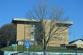
Russell Springs is a home rule-class city in Russell County, Kentucky, in the United States. The city is the gateway to Lake Cumberland, one of the largest man-made lakes in the region, created by Wolf Creek Dam. It is the largest city in the county, having a population of 2,441 during the year 2010 U.S. Census.

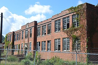
Williamsburg is a home rule-class city in and the county seat of Whitley County, on the southeastern border of Kentucky, United States. The population was 5,326 at the 2020 census. Developed along the Cumberland River, the city was founded in 1818 and named after William Whitley.

The Transylvania Colony, also referred to as the Transylvania Purchase, was a short-lived, extra-legal colony founded in early 1775 by North Carolina land speculator Richard Henderson, who formed and controlled the Transylvania Company. Henderson and his investors had reached an agreement to purchase a vast tract of Cherokee lands west of the southern and central Appalachian Mountains through the acceptance of the Treaty of Sycamore Shoals with most leading Cherokee chieftains then controlling these lands. In exchange for the land the tribes received goods worth, according to the estimates of some scholars, about 10,000 British pounds. To further complicate matters, this frontier land was also claimed by the Virginia Colony and a southern portion by Province of North Carolina.

The Cumberland River is a major waterway of the Southern United States. The 688-mile-long (1,107 km) river drains almost 18,000 square miles (47,000 km2) of southern Kentucky and north-central Tennessee. The river flows generally west from a source in the Appalachian Mountains to its confluence with the Ohio River near Paducah, Kentucky, and the mouth of the Tennessee River. Major tributaries include the Obey, Caney Fork, Stones, and Red Rivers.
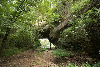
Creelsboro Natural Bridge is a natural bridge in southwestern Russell County, Kentucky, United States. It is located near the community of Creelsboro, approximately 7 miles (11 km) downstream from Wolf Creek Dam, which impounds Lake Cumberland. The Rockhouse is classified as a meander natural bridge because it was created by river erosion of a cliff on the outer side of a sharp meander in the river. Jim Creek flows through it before merging into the Cumberland River. With a span of 104 feet (32 m), it is the seventh largest natural bridge in the United States.
Ages is an unincorporated coal town and census-designated place (CDP) in Harlan County, Kentucky, United States.
Coxton is an unincorporated coal town and census-designated place (CDP) in Harlan County, Kentucky, United States. Their post office is closed. The community was listed as a CDP in 2014, so no population figures are available from the 2010 census.

Kentucky Route 379 (KY 379) is a 27.483-mile-long (44.230 km) state highway in Kentucky with two disjoint sections. The southern segment runs from KY 1880 near Claywell to the Cumberland River in Cumberland County. The northern segment begins at KY 771 near Ribbon and extends north to U.S. Route 127 in Russell Springs in Russell County.


