Cumberland is one of the historic counties of England.

Russell County is a county located in the U.S. Commonwealth of Kentucky. As of the 2020 census, the population was 17,991. Its county seat is Jamestown and its largest city is Russell Springs. The county was formed on December 14, 1825, from portions of Adair, Cumberland and Wayne Counties and is named for William Russell.

Harlan County is a county located in southeastern Kentucky. As of the 2020 census, the population was 26,831. Its county seat is Harlan. It is classified as a moist county—a county in which alcohol sales are prohibited, but containing a "wet" city, in this case Cumberland, where package alcohol sales are allowed. In the city of Harlan, restaurants seating 100+ may serve alcoholic beverages.

Cumberland County is a county located in the Pennyroyal Plateau region of the U.S. state of Kentucky. As of the 2020 census, the population was 5,888. Its county seat is Burkesville. The county was formed in 1798 and named for the Cumberland River, which in turn may have been named after the Duke of Cumberland or the English county of Cumberland.

Adair County is a county located in the U.S. state of Kentucky. As of the 2020 census, the population was 18,903. Its county seat and only municipality is Columbia. The county was founded in 1801 and named for John Adair, then Speaker of the House in Kentucky and later Governor of Kentucky. Adair County has some of the few surviving American Chestnut trees in the United States.

Cumberland is a home rule-class city in Harlan County, Kentucky, in the United States. The population according to the 2010 Census was 2,237, down from 2,611 at the 2000 census.

Somerset is a home rule-class city in Pulaski County, Kentucky, United States. The city population was 11,924 according to the 2020 census. It is the seat of Pulaski County.

Russell Springs is a home rule-class city in Russell County, Kentucky, in the United States. The city is the gateway to Lake Cumberland, one of the largest man-made lakes in the region, created by Wolf Creek Dam. It is the largest city in the county, having a population of 2,441 during the year 2010 U.S. Census.

The Cumberland River is a major waterway of the Southern United States. The 688-mile-long (1,107 km) river drains almost 18,000 square miles (47,000 km2) of southern Kentucky and north-central Tennessee. The river flows generally west from a source in the Appalachian Mountains to its confluence with the Ohio River near Paducah, Kentucky, and the mouth of the Tennessee River. Major tributaries include the Obey, Caney Fork, Stones, and Red Rivers.

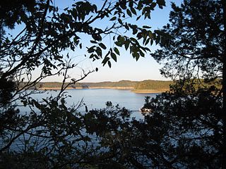
Lake Cumberland is a reservoir in Clinton, Pulaski, Russell, Wayne, and Laurel, counties in Kentucky. The primary reasons for its construction were a means for flood control and the production of hydroelectric power. Its shoreline measures 1,255 miles (2,020 km) and the lake covers 65,530 acres (265 km2) at the maximum power pool elevation. The reservoir ranks 9th in the U.S. in size, with a capacity of 6,100,000 acre-feet (7.5 km3) of water, enough to cover the entire Commonwealth of Kentucky with 3 inches (76 mm) of water. The main lake is 101 miles (163 km) long and over one mile (1.6 km) across at its widest point.

Lake Barkley, a 58,000-acre (230 km2) reservoir in Livingston County, Lyon County and Trigg County in Kentucky and extending into Stewart County and Houston County in Tennessee, was impounded by the U.S. Army Corps of Engineers in 1966 upon the completion of Barkley Dam. Both the lake and the dam are named for Vice President Alben Barkley, a Kentucky native.
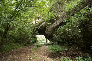
Creelsboro Natural Bridge is a natural bridge in southwestern Russell County, Kentucky, United States. It is located near the community of Creelsboro, approximately 7 miles (11 km) downstream from Wolf Creek Dam, which impounds Lake Cumberland. The Rockhouse is classified as a meander natural bridge because it was created by river erosion of a cliff on the outer side of a sharp meander in the river. Jim Creek flows through it before merging into the Cumberland River. With a span of 104 feet (32 m), it is the seventh largest natural bridge in the United States.

The Louie B. Nunn Cumberland Parkway is a 92-mile-long (148 km) east–west controlled-access highway in the U.S. state of Kentucky, extending from Barren County in the west to Somerset in the east. It is one of seven named highways designated in Kentucky's parkway system.
Kingdom Come State Park is a part of Kentucky's state park system in Harlan County atop Pine Mountain near the city of Cumberland. It was named after the 1903 best-selling novel The Little Shepherd of Kingdom Come by native Kentuckian John Fox, Jr. Features of the park include Raven Rock, Log Rock, and a 3.5-acre (1.4 ha) mountain lake. The section of the park is also a legally dedicated state nature preserve by the Office of Kentucky Nature Preserves.
Lake Cumberland State Resort Park is a state park located on the northern shore of Lake Cumberland near Jamestown, Kentucky in Russell County. The park itself encompasses 3,117 acres (1,261 ha), while the lake, its major feature, covers approximately 50,250 acres (20,340 ha).
WJKY is a radio station broadcasting a Sports radio format. It is licensed to Jamestown, Kentucky, United States, and serving the Russell County, Kentucky area, including Jamestown and Russell Springs. The station is owned by Lake Cumberland Broadcasters and is affiliated with ESPN Radio.

Kentucky Route 92 (KY 92) is a 112.485-mile-long (181.027 km) state highway Kentucky. The route is split into two segments by Lake Cumberland, one of a few state routes in Kentucky with two discontinued segments on both sides of a body of water. The western segment, which is 17.221-mile-long (27.715 km), runs from Kentucky Route 55 west of Joppa to a dead end on Lake Cumberland south of Jamestown via Joppa, Montpelier, Esto, and Jamestown. The eastern segment, which is 95.264-mile-long (153.313 km), runs from a boat ramp on Lake Cumberland northwest of Monticello to U.S. Route 25E west of Fourmile via Monticello, Barrier, Stearns, Carpenter, Timsley, and Ingram.

U.S. Route 127 (US 127) in Kentucky runs 207.7 miles (334.3 km) from the Tennessee state line in rural Clinton County to the Ohio state line in Cincinnati. The southern portion of the route is mostly rural, winding through various small towns along the way. It later runs through the state capital of Frankfort before continuing north, eventually passing through several Cincinnati suburbs in Northern Kentucky, joining US 42 near Warsaw and US 25 in Florence before crossing the Ohio River via the Clay Wade Bailey Bridge.
Smith is an unincorporated community in Harlan County, Kentucky, United States. The community lies along Kentucky State Route 987 and the Martins Fork of the Cumberland River. Smith is also home to Martins Fork Lake. The lake was constructed by the US Army Corps of Engineers as part of several flood control projects along the Cumberland River. The dam was complete and functional in November 1978. Until the early 1970s the community was served by Smith Elementary School. When plans were being made for construction to Martins Fork Lake, the school was closed and students were sent to nearby Cawood Elementary. The community post office was closed in the early 1990s. The community today is served by four churches. Pace Chapel, New Riverside Baptist Church, Full-Gospel Pentecostal Church and Faith-Holiness Church.


