
Snowdon is the highest mountain in Wales, at an elevation of 1,085 metres (3,560 ft) above sea level, and the highest point in the British Isles outside the Scottish Highlands. It is located in Snowdonia National Park in Gwynedd.

Pen y Fan is the highest peak in South Wales, situated in the Brecon Beacons National Park. At 886 metres (2,907 ft) above sea-level, it is also the highest British peak south of Cadair Idris in Snowdonia. It is the highest point of the historic county of Brecknockshire. The twin summits of Pen y Fan and Corn Du at 873 m (2,864 ft) were formerly referred to as Cadair Arthur or 'Arthur's Seat'.

Aran Fawddwy is a mountain in southern Snowdonia, Wales, United Kingdom. It is the highest point of the historic county of Merionethshire. It is the only peak in Wales outside North Snowdonia above 900m, and higher than anywhere in Great Britain outside Northern Snowdonia, the Scottish Highlands and the Lake District. The nearest urban centres to the mountain are Dinas Mawddwy to the south, Llanymawddwy to the southeast, Llanuwchllyn on the shores of Bala Lake to the north, and Rhydymain to the west. The nearest settlements with around 2,000 people are Bala and Dolgellau. On the eastern slopes of Aran Fawddwy is the small lake named Creiglyn Dyfi, the source of the River Dyfi. Its sister peak is Aran Benllyn at 885 metres (2,904 ft). There is also a middle peak- Erw y Ddafad-ddu.

Snaefell – is the highest mountain and the only summit higher than 2,000 feet (610 m) on the Isle of Man, at 2,037 feet (620.9 m) above sea level. The summit is crowned by a railway station, cafe and several communications masts.

Cadair Berwyn or Cader Berwyn is a mountain summit in north-east Wales with a height of 832 metres (2,730 ft) above sea level. It is the highest point in the Berwyn range, the highest in North East Wales and the highest significant summit in Wales outside the National Parks. Cadair Berwyn and Foel Cedig to the west are the two Marilyns that form the Berwyn range. The undulating plateau of the range also includes a large number of other summits above 2,000 feet (610 m), including satellite summits of Cadair Berwyn and many which are classed as Nuttalls.

Pentyrch is a village and community located on the western outskirts of Cardiff, the capital city of Wales. The village gives its name to a Cardiff local authority electoral ward, Pentyrch, which covers the village and immediate surrounding area. The Pentyrch community includes the neighbouring village of Creigiau and Gwaelod y Garth. People living in Pentyrch are commonly known as "Penterchyians".

Pen Llithrig y Wrach is a mountain peak in Snowdonia, North Wales. It is one of the four Marilyns that make up the Carneddau range. To the east is Creigiau Gleision, another Marilyn, while to the west is Pen yr Helgi Du and Carnedd Llewelyn. Craig Eigiau and Llyn Eigiau can be seen to the north, while Gallt yr Ogof, Glyder Fach and Tryfan can be viewed to the south.

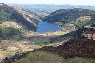
Llyn Cowlyd is the deepest lake in northern Wales. It lies in the Snowdonia National Park at the upper end of Cwm Cowlyd on the south-eastern edge of the Carneddau range of mountains, at a height of 1,164 feet (355 m) above sea level. The lake is long and narrow, measuring nearly 2 miles (3 km) long and about a third of a mile wide, and covers an area of 269 acres (1.1 km2). It has a mean depth of 109 feet (33 m) and at its deepest has given soundings of 229 feet (70 m), this being some 45 ft (14 m) greater than its natural depth, the water surface having been raised twice by the building of dams.
Llyn Crafnant is a lake that lies in a valley in Wales where the northern edge of the Gwydir Forest meets the lower slopes of the Carneddau mountains and, more specifically, the ridge of Cefn Cyfarwydd. The head of the valley offers a profile of crags which are silhouetted at sunset. The Forest Park guide (2002) states that "the is one of the most breathtaking views in all Snowdonia". The summits include Crimpiau 475 metres, and Craig Wen 548 metres which provide views to Moel Siabod and the Ogwen Valley, and Snowdon. Further up is Creigiau Gleision. At 63 acres (250,000 m2) it is the best part of a mile long, although it was clearly once much longer - its southern end shows the evidence of centuries of silting. Jehu's survey (see references) recorded a maximum depth of 71 ft (22 m).

The mountains and hills of the British Isles are categorised into various lists based on different combinations of elevation, prominence, and other criteria such as isolation. These lists are used for peak bagging, whereby hillwalkers attempt to reach all the summits on a given list, the oldest being the 282 Munros in Scotland, created in 1891.

Tal y Fan is an outlying peak of the Carneddau mountains in North Wales. It is one of the four Marilyns that make up the Carneddau, the others being Carnedd Llywelyn, Pen Llithrig y Wrach and Creigiau Gleision.
Creigiau is a dormitory settlement in the north-west of Cardiff, the capital of Wales. The village currently has about 1,500 houses and a population of approximately 5,000 people. The Cardiff electoral ward is called Creigiau/St. Fagans. The village has a strong Welsh-speaking community, and along with Pentyrch has one of the largest clusters of Welsh-speakers in Cardiff. 23.4% of the village speaks Welsh.
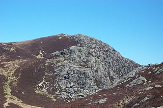
Craiglwyn is a top of Creigiau Gleision in Snowdonia, Wales, near Capel Curig. It lies at the south end of the Creigiau Gleision ridge, and offers good views of Carnedd Dafydd, Pen yr Helgi Du, Pen Llithrig y Wrach, Gallt yr Ogof, Tryfan and Moel Siabod.

Craig Eigiau is a top of Foel Grach in the Carneddau range in Snowdonia, North Wales, Wales.

Creigiau Gleision is a mountain in Snowdonia, Wales, near Capel Curig. It is the easternmost of the high Carneddau and is separated from the others by Llyn Cowlyd. Directly across this reservoir from Creigiau Gleision is Pen Llithrig y Wrach. To the north-east it runs into the broad ridge of Cefn Cyfarwydd.

Cefn Cyfarwydd is a ridge in Conwy county borough, north Wales. It is located above the village of Trefriw on the western side of the Conwy valley, and dramatically separates Cwm Cowlyd and the rugged mountains of the Carneddau from the greener, lusher Conwy valley.

Mount Hay, a mountain that is part of the Mt Hay Range of the Blue Mountains Range which is a spur off the Great Dividing Range, is located in the Blue Mountains National Park, New South Wales, Australia. It is located approximately 100 kilometres (62 mi) west of Sydney and 10 kilometres (6.2 mi) north of the nearest town, Wentworth Falls. Mount Hay is approximately 944 metres (3,097 ft) AMSL and is one of several basalt caps located within the UNESCO World Heritage Greater Blue Mountains Area.
Creigiau railway station was a railway station in Creigiau in south Wales. It was on the Barry Railway between Efail Isaf and Wenvoe, which ran broadly north–south through Creigiau. To the east of the station, a second former line headed north-west towards Llantrisant, and south-east towards Cardiff. There was no connection between these lines; the Barry Railway line passed over the former Llantrisant and Taff Vale Junction Railway's and later Taff Vale Railway's Waterhall branch to the north of the station. During the Second World War, the station was used to transfer American military to the nearby hospital at Rhydlafar. The Railway closed in 1962.
The Gleision Colliery mining accident was a mining accident which occurred on 15 September 2011 at the Gleision Colliery, a drift mine at Cilybebyll in Neath Port Talbot, in Wales. The accident occurred while seven miners were working with explosives on a narrow coal seam. Following a blasting operation into a separate disused flooded mine network to increase air-circulation, the tunnel in which the miners were working began to fill with water. Three of the miners escaped, with one being taken to hospital with life-threatening injuries, while the others were trapped underground. A search and rescue operation was launched to locate the four remaining miners, but they were found deceased the following day. The incident is the worst mining disaster to occur in Wales for three decades.
