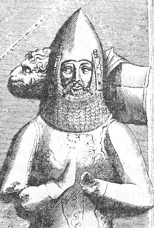
Rhys ap Gruffydd, commonly known as The Lord Rhys, in Welsh Yr Arglwydd Rhys was the ruler of the Welsh kingdom of Deheubarth in south Wales from 1155 to 1197 and native Prince of Wales.

Deheubarth was a regional name for the realms of south Wales, particularly as opposed to Gwynedd. It is now used as a shorthand for the various realms united under the House of Dinefwr, but that Deheubarth itself was not considered a proper kingdom on the model of Gwynedd, Powys, or Dyfed is shown by its rendering in Latin as dextralis pars or as Britonnes dexterales and not as a named land. In the oldest British writers, Deheubarth was used for all of modern Wales to distinguish it from Hen Ogledd, the northern lands whence Cunedda originated.
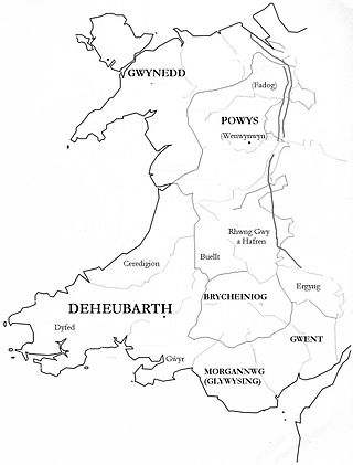
Seisyllwg was a petty kingdom of medieval Wales. It is unclear when it emerged as a distinct unit, but according to later sources it consisted of the former Kingdom of Ceredigion plus the region known as Ystrad Tywi. Thus it covered the modern county of Ceredigion, part of Carmarthenshire, and the Gower Peninsula. It is evidently named after Seisyll, king of Ceredigion in the 7th or early 8th century, but it is unknown if he was directly responsible for its establishment. In the 10th century Seisyllwg became the centre of power for Hywel Dda, who came to rule most of Wales. In 920 Hywel merged Seisyllwg with the Kingdom of Dyfed to form the new kingdom of Deheubarth.
Gruffydd ap Rhys was Prince of Deheubarth, in Wales. His sister was the Princess Nest ferch Rhys. He was the father of Rhys ap Gruffydd, known as 'The Lord Rhys', who was one of the most successful rulers of Deheubarth during this period.
Maelgwn ap Rhys was prince of part of the kingdom of Deheubarth in south west Wales.
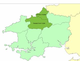
Cemais was an ancient cantref of the Kingdom of Dyfed, from the 11th century a Norman Marcher Lordship, from the 16th century a Hundred, and is now part of Pembrokeshire, Wales. It occupied the coastal area between the Teifi estuary and Fishguard, and the northern and southern slopes of the Preseli Hills, covering an area of approximately 140 square miles (360 km2). The Afon Nyfer divided it into two commotes: Cemais Is Nyfer to the north and Cemais Uwch Nyfer to the south.
The Kingdom of Ceredigion was one of several Welsh kingdoms that emerged in post-Roman Britain in the mid-5th century. Cardigan Bay to the west and the surrounding hilly geography made it difficult for foreign invaders to conquer. Its area corresponded roughly to that of the county of Ceredigion. Ceredigion transparently means "the people of Ceredig." The kingdom as an independent entity ceased to exist around the year 872.

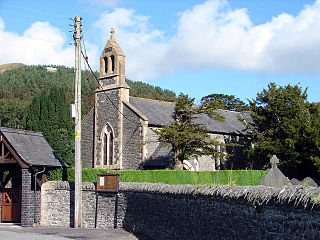
Saint Padarn's Church is a parish church of the Church in Wales, and the largest mediaeval church in mid-Wales. It is at Llanbadarn Fawr, near Aberystwyth, in Ceredigion, Wales, United Kingdom.
This article is about the particular significance of the century 1101–1200 to Wales and its people.

Llanfihangel-y-Creuddyn is an ancient parish in the upper division of the hundred of Ilar, Ceredigion, West Wales, 7 miles south east from Aberystwyth, on the road to Rhayader, comprising the chapelry of Eglwys Newydd, or Llanfihangel y Creuddyn Uchaf, and the township of Llanfihangel y Creuddyn Isaf. It was also known as Lower Llanfihangel y Creuddyn, Lower Llanfihangel y Croyddin and Lower Llanfihangel y Croyddyn. This parish is situated on the rivers Ystwyth, Mynach and Rheidol and intersected by various other streams. An ancient parish was a village or group of villages or hamlets and the adjacent lands. Originally they held ecclesiastical functions, but from the sixteenth century onwards they also acquired civil roles. The parish may have been established as an ecclesiastical parish. Originally a medieval administrative unit, after 1597 ecclesiastical units acquired civil functions with the Elizabethan Poor Laws, which made the parishes responsible for welfare. The civil function was exercised through vestry meetings which administered the Poor Law and were responsible for local roads and bridges.

Trawsgoed is both a community and an estate in Ceredigion, Wales. The estate is 8 miles (13 km) southeast of Aberystwyth, and has been in the possession of the Vaughan family since 1200. The Vaughans are descended from Collwyn ap Tangno, founder of the fifth noble tribe of North Wales, Lord of Eifionydd, Ardudwy, and part of Llŷn, who had his residence on the site of Harlech Castle.
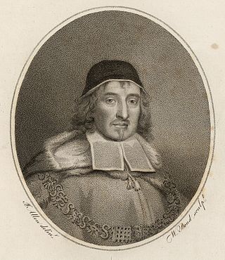
Sir John Vaughan SL, of Trawsgoed, was a justice in the Kingdom of England.
Edward Vaughan was a Welsh lawyer and politician who sat in the House of Commons from 1679 to 1681.
John Vaughan, 1st Viscount Lisburne, of Trawsgoed, Cardiganshire, was a Welsh nobleman.
Saint Afan's Church (SN68387192) is located in Llanafan, 8 miles (13 km) east of Aberystwyth, Ceredigion, in Wales.
Crug Eryr Castle was a motte and bailey-style castle located atop a hill adjacent to the A44 about 2 miles northwest of Llanfihangel Nant Melan, near New Radnor in Powys, Wales. Crug Eryr, which means "the eagle's mount," was likely situated to block the mountain pass into Maelienydd.
Einion ab Owain was a medieval Welsh prince of the House of Dinefwr. He was the eldest son and probable edling of King Owain of Dyfed, son of Hywel Dda.

Cemaes Head is a headland and nature reserve in north Pembrokeshire. It lies in the community of St Dogmaels, within the Pembrokeshire Coast National Park. To the west and north it overlooks Cardigan Bay, and to the east Cardigan Island and the estuary of the River Teifi.

