
Mount Brazeau is a mountain in Alberta, Canada.

The Waterton-Glacier International Peace Park is the union of Waterton Lakes National Park in Canada and Glacier National Park in the United States. Both parks are declared Biosphere Reserves by UNESCO and their union as a World Heritage Site.

The Blue Range is a mountain range of the Canadian Rockies, located on the Continental Divide in Banff National Park, Canada. The range was so named on account of its blueish colour when viewed from afar. Mount Byng is the highest point in the range.

The Municipality of Crowsnest Pass is a specialized municipality in southwest Alberta, Canada. Within the Rocky Mountains adjacent to the eponymous Crowsnest Pass, the municipality formed as a result of the 1979 amalgamation of five municipalities – the Village of Bellevue, the Town of Blairmore, the Town of Coleman, the Village of Frank, and Improvement District No. 5, which included the Hamlet of Hillcrest and numerous other unincorporated communities.
Craigmyle is a hamlet in Alberta, Canada within Starland County. It is located between the towns of Delia and Hanna. It was named in 1912 by a Canadian Northern Railway ahead of the train's arrival in April 1914. The name is said to be based on a Scottish estate. Previously incorporated as a village, Craigmyle dissolved to become a hamlet on 1 January 1972.
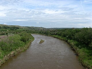
Battle River is a river in central Alberta and western Saskatchewan. It is a major tributary of the North Saskatchewan River.

The Rocky Mountain Foothills are an upland area flanking the eastern side of the Rocky Mountains, extending south from the Liard River into Alberta. Bordering the Interior Plains system, they are part of the Rocky Mountain System or Eastern System of the Western Cordillera of North America.
Bindloss is a hamlet in southern Alberta, Canada within Special Area No. 2. It is located approximately 10 kilometres (6.2 mi) west of Highway 41 and 97 kilometres (60 mi) north of Medicine Hat.
Cardiff is a hamlet in central Alberta, Canada within Sturgeon County. It is located 3 kilometres (1.9 mi) east of Highway 2, approximately 15 kilometres (9.3 mi) north of Edmonton's city limits. The Town of Morinville is 1.6 kilometres (0.99 mi) to the west of Cardiff.
Cessford is a hamlet in southern Alberta, Canada within Special Area No. 2. It is located approximately 22 kilometres (14 mi) east of Highway 36 and 54 kilometres (34 mi) northeast of Brooks.
Chinook is a hamlet in southern Alberta, Canada within Special Area No. 3. It is located on Highway 9 approximately 119 kilometres (74 mi) northeast of Brooks.
Dorothy is a hamlet in southern Alberta, Canada within Special Area No. 2. It is located approximately 21 kilometres (13 mi) east of Highway 56 and 85 kilometres (53 mi) northwest of Brooks.
Edwand is a hamlet in central Alberta, Canada within Smoky Lake County. It is located 4 kilometres (2.5 mi) north of Highway 28, approximately 104 kilometres (65 mi) northeast of Edmonton.
Ensign is a hamlet in southern Alberta, Canada within Vulcan County. It is located approximately 11 kilometres (6.8 mi) south of Highway 23 and 78 kilometres (48 mi) southeast of Calgary.
Fabyan is a hamlet in central Alberta, Canada within the Municipal District of Wainwright No. 61. It is located on Highway 14, approximately 10 kilometres (6.2 mi) west of Wainwright, Alberta, and 78 kilometres (48 mi) southwest of Lloydminster. It is located near the Fabyan Trestle Bridge.
Glenevis is a hamlet in central Alberta, Canada within Lac Ste. Anne County. It is located on Highway 43, approximately 71 kilometres (44 mi) northwest of Edmonton.
Heinsburg is a hamlet in central Alberta, Canada within the County of St. Paul No. 19. It is located approximately 21 kilometres (13 mi) north of Highway 45 and 66 kilometres (41 mi) northwest of Lloydminster.
Iddesleigh is a hamlet in southern Alberta, Canada within Special Area No. 2. It is located approximately 37 kilometres (23 mi) northeast of Highway 1 and 46 kilometres (29 mi) northeast of Brooks.
A mountain formerly known as Mount Pétain, but with no current official name, is located on the border of Alberta and British Columbia (BC) on the Continental Divide. It was named in 1918 after the then-to-be Nazi-collaborator, Marshal Philippe Pétain, who was then an honoured war hero for the Allies of World War I. The name was retained despite the later reversal in Pétain's reputation after his having been Head of State of Vichy France and being partly responsible for the murder of 76,000 Jews.
