
The Illinois River is a principal tributary of the Mississippi River and is approximately 273 miles (439 km) long. Located in the U.S. state of Illinois, the river has a drainage basin of 28,756.6 square miles (74,479 km2). The Illinois River begins with the confluence of the Des Plaines and Kankakee rivers in the Chicago metropolitan area, and it generally flows to the southwest across Illinois, until it empties into the Mississippi near Grafton, Illinois. Its drainage basin extends into southeastern Wisconsin, northwestern Indiana, and a very small area of southwestern Michigan in addition to central Illinois. Along its shores are several river ports, including Peoria, Illinois. Historic recreation areas on the river include Starved Rock and the internationally important wetlands of the Emiquon Complex and Dixon Waterfowl Refuge.

The Great Lakes Waterway (GLW) is a system of natural channels and artificial locks and canals which enable navigation between the North American Great Lakes. Though all of the lakes are naturally connected as a chain, water travel between the lakes was impeded for centuries by obstacles such as Niagara Falls and the rapids of the St. Marys River.

Alanson is a village in Emmet County in the U.S. state of Michigan. The population was 778 at the 2020 census.
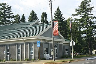
Littlefield Township is a civil township of Emmet County in the U.S. state of Michigan. The population was 2,978 at the 2010 census.
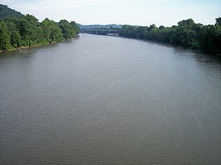
The Muskingum River is a tributary of the Ohio River, approximately 111 miles (179 km) long, in southeastern Ohio in the United States. An important commercial route in the 19th century, it flows generally southward through the eastern hill country of Ohio. Via the Ohio, it is part of the Mississippi River watershed. The river is navigable for much of its length through a series of locks and dams.
The St. Marys River, sometimes written St. Mary's River, drains Lake Superior, starting at the end of Whitefish Bay and flowing 74.5 miles (119.9 km) southeast into Lake Huron, with a fall of 23 feet (7.0 m). For its entire length it is an international border, separating Michigan in the United States from Ontario, Canada.

The Calumet River is a system of heavily industrialized rivers and canals in the region between the south side of Chicago, Illinois, and the city of Gary, Indiana. Historically, the Little Calumet River and the Grand Calumet River were one, the former flowing west from Indiana into Illinois, then turning back east to its mouth at Lake Michigan at Marquette Park in Gary. Now the system is part of the Chicago Area Waterway System and through the use of locks flows away from Lake Michigan to the Cal-Sag Channel.

The Fox–Wisconsin Waterway is a waterway formed by the Fox and Wisconsin Rivers. First used by European settlers in 1673 during the expedition of Marquette & Joliet, it was one of the principal routes used by travelers between the Great Lakes and the Mississippi River until the completion of the Illinois and Michigan Canal in 1848 and the arrival of railroads. The western terminus of the Fox–Wisconsin Waterway was at the Mississippi at Prairie du Chien, Wisconsin. It continued up the Wisconsin River about 116 miles (187 km) until reaching Portage, Wisconsin. There travelers would portage to the Upper Fox River, or eventually, use the Portage Canal. It continued about 160 miles (260 km) down the Fox River, following it through Lake Winnebago and continuing on the Lower Fox over 170 feet of falls to the eastern terminus of Green Bay.
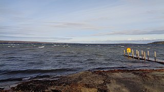
Burt Lake is a 17,120 acres (69.3 km2) lake in Cheboygan County in the U.S. state of Michigan. The western shore of the lake is on the boundary with Emmet County. The lake is named after William Austin Burt, who, together with John Mullett, made a federal survey of the area from 1840 to 1843.

The Keweenaw Waterway is a partly natural, partly artificial waterway which cuts across the Keweenaw Peninsula of Michigan; it separates Copper Island from the mainland. Parts of the waterway are variously known as the Keweenaw Waterway, Portage Canal, Portage Lake Canal, Portage River, Lily Pond, Torch Lake, and Portage Lake. The waterway connects to Lake Superior at its north and south entries, with sections known as Portage Lake and Torch Lake in between. The primary tributary to Portage Lake is the Sturgeon River.
The Chicago Portage was an ancient portage that connected the Great Lakes waterway system with the Mississippi River system. Connecting these two great water trails meant comparatively easy access from the mouth of the St Lawrence River on the Atlantic Ocean to the Rocky Mountains, and the Gulf of Mexico. The approximately six-mile link had been used by Native Americans for thousands of years during the Pre-Columbian era for travel and trade.

The Illinois Waterway system consists of 336 miles (541 km) of navigable water from the mouth of the Calumet River at Chicago to the mouth of the Illinois River at Grafton, Illinois. Based primarily on the Illinois River, it is a system of rivers, lakes, and canals that provide a shipping connection from the Great Lakes to the Gulf of Mexico via the Illinois and Mississippi rivers.
Northwest Indiana, nicknamed The Region after the Calumet Region, comprises Lake, Porter, LaPorte, and Newton counties in Indiana. This region neighbors Lake Michigan and is part of the Chicago metropolitan area. According to the 2020 Census, Northwest Indiana has a population of 831,080 and is the state's second largest urban area after the Indianapolis Metropolitan Area. It is also the home of the Indiana Dunes, parts of which have been preserved through conservation efforts. The town of Ogden Dunes houses the Hour Glass, a museum showcasing the ecological and conservation efforts of O. D. Frank.

The Presumpscot River is a 25.8-mile-long (41.5 km) river located in Cumberland County, Maine, United States. It is the main outlet of Sebago Lake. The river provided an early transportation corridor with reliable water power for industrial development of the city of Westbrook and the village of South Windham.

The Inland Waterway or Inland Water Route is a 38-mile-long (61 km) series of rivers and lakes in the U.S. state of Michigan. With only a short portage, it forms a navigable route for small craft connecting Lake Huron and Crooked Lake, across the Northern Michigan region. Despite Little Traverse Bay being only 2 miles west of Crooked Lake, the waterway does not connect to it, making Lake Michigan inaccessible through this route.

The Cheboygan River is a short but significant river in the Lake Huron drainage basin of the U.S. state of Michigan.

The Kankakee Outwash Plain is a flat plain interspersed with sand dunes in the Kankakee River valley in northwestern Indiana and northeastern Illinois of the United States. It is just south of the Valparaiso Moraine and was formed during the Wisconsin Glaciation. As the glacier stopped at the Valparaiso Moraine, its meltwater was carried away to the outwash plain. On the south side of the moraine, where the elevation drops, the meltwaters eroded away valleys, carrying sand and mud with them. As the muddy meltwater reached the valley where the slope lessened, the water slowed, depositing the sand on the outwash plain. This created a smooth, flat, and sandy plain. Before its draining, the Kankakee Marsh, located on the outwash plain, was one of the largest freshwater marshes in the United States.

Ponshewaing is an unincorporated community and census-designated place (CDP) in Emmet County in the U.S. state of Michigan. As of the 2010 census, the CDP had a population of 69. It is located within Littlefield Township.
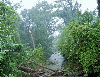
The Crooked River (Michigan) is a river in Emmet and Cheboygan counties in the U.S. state of Michigan. It is a short stream, 5.6 miles (9.0 km) long, flowing northeast from Crooked Lake at 45°25′58″N84°47′19″W near Alanson into Burt Lake at 45°28′14″N84°43′38″W. It forms part of the Inland Waterway of Michigan. The river is the subject of the Sufjan Stevens song "Alanson, Crooked River" from his 2003 album Michigan.
The East Arm Little Calumet River, also known as the Little Calumet River East Branch, is a 22.1-mile-long (35.6 km) portion of the Little Calumet River that begins just east of Holmesville, Indiana in New Durham Township in LaPorte County and flows west to Porter County and the Port of Indiana-Burns Waterway.

