Crown Prince Frederick Range

Last updated
Crown Prince Frederick Range
Kronprins Frederik Bjerge
Crown Prince Frederick Range-pclmaps-oclc-8322829 c 13.jpg
Defense Mapping Agency map of Greenland detail showing the area of the range.
Highest point
Elevation 3,256 m (10,682 ft)
Dimensions
Length130 km (81 mi)NE/SW
Width40 km (25 mi)NW/SE
Geography
Greenland edcp relief location map.jpg
Red triangle with thick white border.svg
Location in Greenland
Country Greenland
Range coordinates 67°30′N34°40′W / 67.500°N 34.667°W / 67.500; -34.667 Coordinates: 67°30′N34°40′W / 67.500°N 34.667°W / 67.500; -34.667

The Crown Prince Frederick Range (Danish : Kronprins Frederik Bjerge) [1] is a large mountain range in King Christian IX Land, eastern Greenland. Administratively this range is part of the Sermersooq Municipality.

Contents

Despite being relatively unknown it has some of the highest summits in Greenland.

History

The Crown Prince Frederick Range was first surveyed by Sir Martin Lindsay in 1934 during the British Trans-Greenland Expedition and was named after the Crown Prince Frederick of Denmark (1899 – 1972) who would be crowned King Frederick IX in 1947. [2] [3] The expedition crossed Greenland from west to east, and succeeded in fixing the positions of many other important features further to the northeast, including Gunnbjørnsfjeld —the highest point in Greenland. On the return journey the team headed south-west to Amassalik and on their journey discovered the extent of the Crown Prince Frederick Range. Lindsay's expedition set a new world record after travelling 1,050 mi (1,690 km) on sleds, 700 of which were through hitherto unexplored territory. [2] [4]

Following Martin Lindsay's pioneering venture few expeditions visited the range which remained almost consigned to oblivion for many decades. [5] Finally in 1995 the first guided icecap journey through the range was organized [6] [7] and the following year, in July and August 1996, a number of the main summits of the range were climbed for the first time by members of the Tangent British East Greenland Expedition, including Paul Walker. The expedition set up its base camp at 67°11′56″N35°6′30″W / 67.19889°N 35.10833°W / 67.19889; -35.10833 and from there climbed a total of 55 peaks. [8] [7] [9]

Geography

The Crown Prince Frederick Range is a group of nunataks scattered over a vast region between the Greenland Ice Sheet and the coast. It extends for about 130 km (81 mi) in a northeast-southwest direction between the 67th (Schweizerland) and the 68th parallel north (Hutchinson Glacier). The range is located to the northeast of Mont Forel and southwest of Kangerlussuaq Fjord. The level expanses between the nunatak clusters of the range are usually very wide and permanently covered with ice and snow. The average height of the intermontane areas is between 1,600 m (5,200 ft) and 2,000 m (6,600 ft). [10]

The region of the Crown Prince Frederick Mountains is uninhabited, the nearest settlement being Tasiilaq, located about 175 km to the SSW of the southern end of the range. [1] [10]

Subranges

Panorama Nunatak ( 68°12′N33°12′W / 68.200°N 33.200°W / 68.200; -33.200 ) [11] and Redkammen ( 68°13′N32°26′W / 68.217°N 32.433°W / 68.217; -32.433 ) [12] are two large nunataks at the northeastern end. They are located to the southwest and to the southeast of the Hutchinson Plateau respectively and are sometimes included as part of the Crown Prince Frederick Range. [13]

Mountains

Although most peaks of the Crown Prince Frederick Range are yet unnamed, quite a number of the nunataks have very high summits and a total of nine have peaks are higher than 3,000 m (9,800 ft). Owing to its remote location this large range has been somewhat neglected by mountaineers though, despite some impressive peaks of good granite.

Climate

From the north and from the west the range is fully exposed to the influence of the Greenland Ice Sheet. [9] As there is no barrier to the shrieking cold winds of the icy expanse, ice cap climate prevails in the region.

The average annual temperature in the area of the Crown Prince Frederick Range is -14 °C. The warmest month is July when the average temperature reaches -2 °C and the coldest is March when the temperature sinks to -20 °C. [14]

See also

Further reading

Related Research Articles

<span class="mw-page-title-main">Frederik, Crown Prince of Denmark</span> Crown Prince of Denmark

Frederik, Crown Prince of Denmark, Count of Monpezat, is the heir apparent to the Danish throne. He is the elder son of Queen Margrethe II and Prince Henrik.

The Aramis Range is the third range south in the Prince Charles Mountains, situated 11 miles southeast of the Porthos Range and extending for about 30 miles in a southwest–northeast direction. First visited in January 1957 by Australian National Antarctic Research Expeditions (ANARE) southern party led by W.G. Bewsher, who named it for a character in Alexandre Dumas' novel The Three Musketeers, the most popular book read on the southern journey.

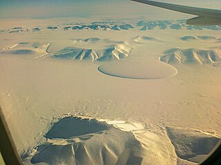
Wandel Land is a 15.7 km (52,000 ft) nunatak in Avannaata municipality in northwestern Greenland. It is one of several nunataks in the Melville Bay region of Greenland, where the Greenland ice sheet drains into the bay alongside its entire length apart from an occasional nunatak.

<span class="mw-page-title-main">Watkins Range</span> Mountain range in Greenland

The Watkins Range is Greenland's highest mountain range. It is located in King Christian IX Land, Sermersooq municipality.

<span class="mw-page-title-main">Kangerlussuaq Fjord, East Greenland</span> Body of water

Kangerlussuaq Fjord is a fjord in eastern Greenland. It is part of the Sermersooq municipality.

<span class="mw-page-title-main">King Frederick VIII Land</span> Region in Greenland

King Frederick VIII Land is a major geographic division of northeastern Greenland. It extends above the Arctic Circle from 76°N to 81°N in a N/S direction along the coast of the Greenland Sea.

<span class="mw-page-title-main">Schweizerland</span> Mountain range in eastern Greenland

Schweizerland, also known as Schweizerland Alps, is a mountain range in King Christian IX Land, eastern Greenland. Administratively this range is part of the Sermersooq Municipality. Its highest point is one of the highest peaks in Greenland.

<span class="mw-page-title-main">Queen Louise Land</span> Mountainous region in northeastern Greenland

Queen Louise Land is a vast mountainous region located west of Dove Bay, King Frederick VIII Land, northeastern Greenland. Administratively it is part of the Northeast Greenland National Park zone.

<span class="mw-page-title-main">Lemon Range</span> Mountain range in Greenland

The Lemon Range or Lemon Mountains is a mountain range in King Christian IX Land, eastern Greenland. Administratively this range is part of the Sermersooq Municipality.

<span class="mw-page-title-main">Borgtinderne</span>

Borgtinderne, meaning 'Castle Pinnacles' in the Danish language, is a mountain range in King Christian IX Land, eastern Greenland. Administratively this range is part of the Sermersooq Municipality.

<span class="mw-page-title-main">Gronau Nunataks</span>

The Gronau Nunataks is a mountain range in King Christian IX Land, eastern Greenland. Administratively this range is part of the Sermersooq Municipality.

<span class="mw-page-title-main">Ejnar Mikkelsen Range</span> Mountain range in Greenland

Ejnar Mikkelsen Range is a mountain range in King Christian IX Land, eastern Greenland. Administratively it is part of the Sermersooq Municipality.

<span class="mw-page-title-main">Princess Elizabeth Alps</span>

The Princess Elizabeth Alps is a mountain range in King Frederick VIII Land, northeastern Greenland. Administratively this range is part of the Northeast Greenland National Park zone.

<span class="mw-page-title-main">Lindbergh Range</span> Mountain range in Greenland

The Lindbergh Range or Lindbergh Nunataks is a mountain range in King Christian IX Land, eastern Greenland. Administratively the range is part of the Sermersooq Municipality.

The Graah Mountains are a mountain range in southeastern Greenland. Administratively this range is part of the Kujalleq municipality.

<span class="mw-page-title-main">Lilloise Range</span> Mountain range in eastern Greenland

The Lilloise Range or Lilloise Mountains is a mountain range in King Christian IX Land, eastern Greenland. Administratively this range is part of the Sermersooq Municipality.

<span class="mw-page-title-main">Roosevelt Range</span>

The Roosevelt Range or Roosevelt Mountains is a mountain range in Northern Greenland. Administratively this range is part of the Northeast Greenland National Park. Its highest peak is the highest point in Peary Land.

The Kangerluluk Range is a mountain range in the King Frederick VI Coast, southeastern Greenland. Administratively this range is part of the Kujalleq municipality.

References

  1. 1 2 "Kronprins Frederik Bjerge". Mapcarta. Retrieved 27 July 2016.
  2. 1 2 "French Honour For British Explorer", The Times, 12 April 1935.
  3. The Development of Mountaineering in East and North-East Greenland An Outline History
  4. Sr Martin Lindsay's granddaughter's adventure - The Sunday Times
  5. Philip Bartlett, Undiscovered Mountains of the Kronprins Frederiks Bjerge - Alpine Journal
  6. "Tangent Expedition - Greenland Icecap Crossings". Archived from the original on 2016-06-24. Retrieved 2016-07-28.
  7. 1 2 3 1997 American Alpine Journal, p. 222-225
  8. "Tangent Expedition Reports". Archived from the original on 2016-06-24. Retrieved 2016-07-27.
  9. 1 2 North America, Greenland, Kronprins Frederik Bjerge, Various Ascents
  10. 1 2 3 4 5 6 7 8 9 10 11 12 13 14 15 16 17 18 19 20 21 22 23 24 25 26 27 28 29 30 31 32 33 Google Earth
  11. "Panoramanunatakker". Mapcarta. Retrieved 5 January 2017.
  12. "Redekammen". Mapcarta. Retrieved 5 January 2017.
  13. American Alpine Journal, 1991, Volume 33 p. 374
  14. "NASA Earth Observations Data Set Index". NASA. Archived from the original on 7 April 2019. Retrieved 30 January 2016.