Related Research Articles

The Highlands is a historical region of Scotland. Culturally, the Highlands and the Lowlands diverged from the Late Middle Ages into the modern period, when Lowland Scots language replaced Scottish Gaelic throughout most of the Lowlands. The term is also used for the area north and west of the Highland Boundary Fault, although the exact boundaries are not clearly defined, particularly to the east. The Great Glen divides the Grampian Mountains to the southeast from the Northwest Highlands. The Scottish Gaelic name of A' Ghàidhealtachd literally means "the place of the Gaels" and traditionally, from a Gaelic-speaking point of view, includes both the Western Isles and the Highlands.

Kincardineshire, also known as the Mearns, is a historic county, registration county and lieutenancy area on the coast of northeast Scotland. It is bounded by Aberdeenshire on the north and west, and by Angus on the south.

The Mounth is the broad upland in northeast Scotland between the Highland Boundary and the River Dee, at the eastern end of the Grampians.

Kildrummy Castle is a ruined castle near Kildrummy, in Aberdeenshire, Scotland. Though ruined, it is one of the most extensive castles dating from the 13th century to survive in eastern Scotland, and was the seat of the Earls of Mar. It is owned today by Historic Environment Scotland and is open to the public as a scheduled ancient monument with gardens that are included in the Inventory of Gardens and Designed Landscapes in Scotland.
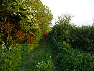
A drovers' road, drove road, droveway, or simply a drove, is a route for droving livestock on foot from one place to another, such as to market or between summer and winter pasture. Many drovers' roads were ancient routes of unknown age; others are known to date back to medieval or more recent times.
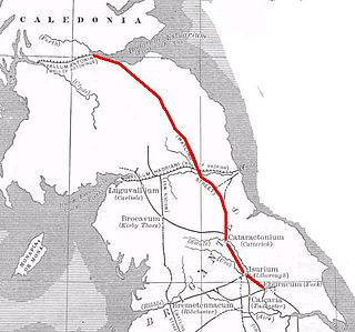
Dere Street or Deere Street is a modern designation of a Roman road which ran north from Eboracum (York), crossing the Stanegate at Corbridge and continuing beyond into what is now Scotland, later at least as far as the Antonine Wall. Portions of its route are still followed by modern roads, including the A1(M), the B6275 road through Piercebridge, where Dere Street crosses the River Tees, and the A68 north of Corbridge in Northumberland.

Historic roads are paths or routes that have historical importance due to their use over a period of time. Examples exist from prehistoric times until the early 20th century. They include ancient trackways, long-lasting roads, important trade routes, and migration trails. Many historic routes, such as the Silk Road, the Amber Road, and the Royal Road of the Persian Empire, covered great distances and their impact on human settlements remain today.

Cairn O' Mounth/Cairn O' Mount is a high mountain pass in Aberdeenshire, Scotland. The place name is a survival of the ancient name for what are now the Grampian Mountains, earlier called "the Mounth". The name change happened from circa 1520 AD. The Ordnance Survey shows the name as Cairn o' Mount.
The Portlethen Moss is an acidic bog nature reserve located to the west of the town of Portlethen, Aberdeenshire in Scotland. Like other mosses, this wetland area supports a variety of plant and animal species, even though it has been subject to certain development and agricultural degradation pressures. For example, the Great Crested Newt was found here prior to the expansion of the town of Portlethen. Many acid loving vegetative species occur in Portlethen Moss, and the habitat is monitored by the Scottish Wildlife Trust.

Lumphanan is a village in Aberdeenshire, Scotland located 25 miles (40 km) from Aberdeen and 10 miles (16 km) from Banchory.
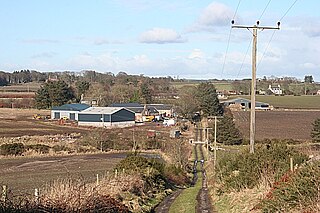
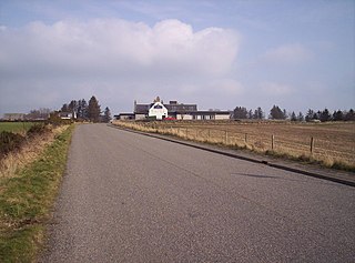
The Causey Mounth is an ancient drovers' road over the coastal fringe of the Grampian Mountains in Aberdeenshire, Scotland. This route was developed as the main highway between Stonehaven and Aberdeen around the 12th century AD and it continued to function as the principal route connecting these two cities until the mid 20th century, when modern highway construction of the A90 road occurred in this area. There are extant paved and usable sections of this road over part of the alignment; however, many parts of the ancient route are no more than footpaths, and in some cases the road has vanished into agricultural fields. Constructed in the Middle Ages, the Causey Mounth was created as an elevated rock causeway to span many of the boggy areas such as the Portlethen Moss. A considerable portion of the alignment of the Causey Mounth is illustrated on the UK Ordnance Survey Map, although a large fraction of the route cannot be navigated by a conventional passenger vehicle.

Elsick House is a historic house in Kincardineshire, North-East Scotland. It is situated in an agricultural area about two miles from the North Sea near the town of Newtonhill; the Elsick Estate is situated within the watershed of the Burn of Elsick, a stream that traverses the estate. The house is located on the Elsick Estate, and is the present family seat of the Duke of Fife.
Cammachmore is a hamlet in the coastal region near the North Sea in Aberdeenshire. It lies slightly west of the A92 road and the ancient Causey Mounth passes through the community. Historic Elsick House is situated due west of Cammachmore. Other nearby historic features include Gillybrands, Saint Ternan's Church, Muchalls Castle and the Lairhillock Inn.

Stob a' Choire Odhair is a Scottish mountain situated eight kilometres north west of Bridge of Orchy on the border of the Argyll and Bute and Highland council areas.

Cowie is an historic fishing village in Kincardineshire, Scotland. This village has existed since the Middle Ages, but in current times it is effectively subsumed into the town of Stonehaven. It had an estimated population of 2,720 in 2020.

Grim Brigs is a rocky headland on the North Sea at Muchalls, Scotland. Notable historic features in this vicinity include St. Ternan's Church, Muchalls Castle and Elsick House. Approximately one kilometre inland is the noted medieval drovers' road known as the Causey Mounth. The geology of Grim Brigs is associated with the harder rock formations north of the Highland Boundary Fault, which forms the boundary between the Scottish Highlands and Lowlands. This Highland Boundary Fault emerges at the North Sea approximately four kilometres south of Grim Brigs near the Chapel of St. Mary and St. Nathalan.

Càrn Aosda is a Scottish mountain situated 12.5 km south of the town of Braemar, in the county of Aberdeenshire. It stands near the summit of the Cairnwell Pass on the A93 road, in the midst of the Glenshee Ski Centre.

Auld Bourtreebush is a large Neolithic stone circle near Portlethen in Aberdeenshire, Scotland. It is also known as Old Bourtree Bush or Old Bourtreebush. This megalithic construction is situated near the Aquhorthies recumbent stone circle and the Causey Mounth, an ancient trackway which connects the Scottish Lowlands to the highlands. It is a scheduled monument.

Hospitals in medieval Scotland can be dated back to the 12th century. From c. 1144 to about 1650 many hospitals, bedehouses and maisons Dieu were built in Scotland.

The Lairig an Laoigh is a mountain pass through the Highlands of Scotland. In speech and sometimes in writing the name is reduced to "Lairig Laoigh". It is of glacial origin, dissecting the Cairngorm plateau, and it runs roughly north–south from Speyside to Deeside at one time being used as a drove road. Between the public road in the Abernethy Forest and the one at Linn of Dee the trekking distance is 31 kilometres (19 mi).
References
- ↑ "Cryne Corse Mounth". Heritage Paths. Scottish Rights of Way and Access Society. Archived from the original on 2 June 2021. Retrieved 28 May 2021.