Cugnasco

Last updated
Cugnasco
Cugnasco.jpg
Cugnasco village
Cugnasco-coat of arms.svg
Location of Cugnasco
Cugnasco
Switzerland adm location map.svg
Red pog.svg
Cugnasco
Reliefkarte Tessin blank.png
Red pog.svg
Cugnasco
Coordinates: 46°11′N8°55′E / 46.183°N 8.917°E / 46.183; 8.917
Country Switzerland
Canton Ticino
District Locarno
Municipality Cugnasco-Gerra
Area
  Total171 km2 (66 sq mi)
Elevation
225 m (738 ft)
Population
 (2006)
  Total1,269
  Density7.4/km2 (19/sq mi)
Time zone UTC+01:00 (Central European Time)
  Summer (DST) UTC+02:00 (Central European Summer Time)
Postal code(s)
6516
SFOS number 5104
LocalitiesBosco, Boscioredo, Massarescio, Medoscio, Moncucco, Pianrestello, Sciarana, La Monda
Website www.cugnasco.ch

Cugnasco is a village in the municipality Cugnasco-Gerra of the district of Locarno in the canton of Ticino in Switzerland.

Contents

Cugnasco had a population of nearly 1300.[ when? ]

Cugnasco was an independent municipality until January 1, 2009, when it merged with Gerra (Verzasca) to form Cugnasco-Gerra.

Location

Cugnasco is on the outskirts of the Magadino valley. It includes the settlements of Boscioredo, Cugnasco, Bosco, Massarescio, Medoscio, Moncucco, Pianrestello and Sciarana. [1]

History

Cugnasco is first mentioned in 1374 as Cunyascho. [1] Today's mountain pastures of Ditto and Curogna are the oldest settlements of the municipality. The settlements in the marshy Ticino river floodplain, developed later. The present village developed mainly due to the herders who brought their cattle down into the Magadino valley for the winter. In the 13th and 14th Centuries there was a migration from Verzasca valley and about 150 inhabitants of Ditto and Curogna moved down into the valley. Cugnasco grew into a center of community life for the surrounding settlements. [1]

As Cugnasco grew, a Servite monastery grew up as well. In 1653, the monastery was closed. However, the Chapel of the Beata Vergine delle Grazie continued to serve for the inhabitants of the plain. Before the chapel, they had to travel to Tenero for worship services. The small 15th Century church, now a heritage site of national significance [2] containing valuable frescoes from the 16th and 17th Century was the goal of many pilgrims from the region.

In 1635-56 the provost's St. Joseph Church was built. It later became a parish center, while Ditto and Curogna still had a Vicariate. Both the chapel of San Martino in Ditto and the SS Cristoforo e Anna in Curogna date from the 14th and 15th Century and contains frescoes from various periods. [1]

Cugnasco was located at the crossroads of two important trade routes from Locarno to Bellinzona and from Cugnasco to Contone, which was near the so-called Porto sul Ticino, a river crossing. After the collapse of the bridge at Bellinzona in 1515, this second route became nearly the only way across the river. Historically, the economy of Cugnasco relied nearly exclusively on agriculture and pastoralism. However, by 2000 less than 15% of workers worked in agriculture and about three quarters were commuters. [1]

Historic population

The historical population is given in the following table:

YearPopulation
Cugnasco [1]
1591285
1760325
1801279
1850349
1900433
1960428
1990821
20001,120

Related Research Articles

<span class="mw-page-title-main">Ticino (river)</span> Tributary of the Po river.

The river Ticino is the most important perennial left-bank tributary of the Po. It has given its name to the Swiss canton through which its upper portion flows.

<span class="mw-page-title-main">Locarno</span> Municipality in Ticino, Switzerland

Locarno is a southern Swiss town and municipality in the district Locarno, located on the northern shore of Lake Maggiore at its northeastern tip in the canton of Ticino at the southern foot of the Swiss Alps. It has a population of about 16,000 (proper), and about 56,000 for the agglomeration of the same name including Ascona besides other municipalities.

<span class="mw-page-title-main">Municipalities of the canton of Ticino</span>

There are 106 municipalities in the canton of Ticino, Switzerland,. Municipalities (comuni) are grouped in circles (circoli) which are part of districts (distretti).

<span class="mw-page-title-main">Bellinzona</span> Municipality in Ticino, Switzerland

Bellinzona is a municipality, a historic Swiss town, and the capital of the canton of Ticino in Switzerland. The town is famous for its three castles that have been UNESCO World Heritage Sites since 2000.

The Locarno District is a district of Canton Ticino, Switzerland. It has a population of 63,774.

<span class="mw-page-title-main">Olivone</span> Former municipality in Ticino, Switzerland

Olivone was a municipality in the district of Blenio in the canton of Ticino in Switzerland.

Bignasco is a village in the district of Vallemaggia, in the canton of Ticino, Switzerland, consolidated into the adjacent municipality of Cevio.

<span class="mw-page-title-main">Gudo</span> Former municipality in Ticino, Switzerland

Gudo is a former municipality in the district of Bellinzona in the canton of Ticino in Switzerland.

<span class="mw-page-title-main">Brione (Verzasca)</span> Former municipality in Ticino, Switzerland

Brione (Verzasca) is a village and former municipality in the district of Locarno in the canton of Ticino in Switzerland. On 17 October 2020 the former municipalities of Vogorno, Sonogno, Corippo, Brione (Verzasca) and Frasco merged to form the new municipality of Verzasca.

<span class="mw-page-title-main">Magadino</span> Former municipality in Ticino, Switzerland

Magadino is a former municipality in the district of Locarno in the canton of Ticino in Switzerland.

Gerra (Verzasca) is a part of the municipality of Cugnasco-Gerra in the district of Locarno in the canton of Ticino in Switzerland.

<span class="mw-page-title-main">Monte Ceneri</span> Mountain pass in Ticino, Switzerland

Monte Ceneri is a mountain pass in the canton of Ticino in Switzerland. It connects the Magadino Plain and the Vedeggio Valley across the Lugano Prealps at an elevation of 554 metres (1,818 ft) above sea level. It provides the most direct route between the cities of Bellinzona and Lugano. Despite its name, Monte Ceneri is the lowest point on the crest between Monte Tamaro and the Camoghè.

<span class="mw-page-title-main">Valle Verzasca</span>

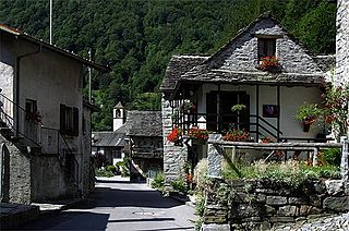
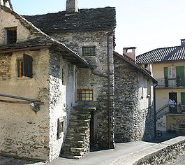
The Valle Verzasca is a valley in the Locarno district of the canton of Ticino, Switzerland. It comprises the municipalities of Mergoscia, Vogorno, Corippo, Lavertezzo, Brione, Gerra, Frasco, and Sonogno. As of 2004, the total population is 3,200. It is the most central valley of Ticino, and none of the passes out of the valley cross cantonal or national borders. The valley is formed by the river Verzasca and is situated between the Leventina and the Maggia and culminates at Pizzo Barone.

<span class="mw-page-title-main">Castles of Bellinzona</span> UNESCO World Heritage Site in Canton of Ticino, Switzerland

The Castles of Bellinzona are a group of fortifications located around the town of Bellinzona, the capital of the Swiss canton of Ticino. Situated on the Alpine foothills, the group is composed of fortified walls and three castles named Castelgrande, Montebello and Sasso Corbaro. Castelgrande is located on a rocky peak overlooking the valley, with a series of walls that protect the old city and connect to Montebello. Sasso Corbaro, the highest of the three castles, is located on an isolated rocky promontory south-east of the other two. The Castles of Bellinzona with their defensive walls have been an UNESCO World Heritage Site since 2000.

<span class="mw-page-title-main">Cugnasco-Gerra</span> Municipality in Ticino, Switzerland

Cugnasco-Gerra is a municipality in the canton of Ticino, Switzerland. It was formed on January 1, 2009, through the merger of Cugnasco and Gerra.

<span class="mw-page-title-main">Gambarogno</span> Municipality in Ticino, Switzerland

Gambarogno is a municipality in the district of Locarno in the canton of Ticino in Switzerland. It was created on 25 April 2010 through the merger of the municipalities of Caviano, Contone, Gerra, Indemini, Magadino, Piazzogna, San Nazzaro, Sant'Abbondio and Vira.

<span class="mw-page-title-main">Monteceneri</span> Municipality in Ticino, Switzerland

Monteceneri is a municipality in the district of Lugano in the canton of Ticino in Switzerland. It was created on 21 November 2010 through the merger of the municipalities of Medeglia, Bironico, Camignolo, Rivera and Sigirino. The first mayor elected was Emilio Filippini, who held the position until 2016.1

<span class="mw-page-title-main">Giubiasco–Locarno railway</span>

The Giubiasco–Locarno railway is a railway in Switzerland. It was built by the Gotthard Railway Company on 20 December 1874 as part of the line through the Ticino valley. With the nationalisation of the Gotthard Railway on 1 May 1909, the line became part of the Swiss Federal Railways (SBB).

<span class="mw-page-title-main">Verzasca, Switzerland</span> Municipality in Ticino, Switzerland

Verzasca is a municipality in the district of Locarno in the canton of Ticino in Switzerland.

<span class="mw-page-title-main">Riazzino railway station</span> Swiss railway station

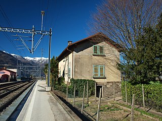
Riazzino railway station is a railway station in the municipality of Locarno, in the Swiss canton of Ticino. It is an intermediate stop on the standard gauge Giubiasco–Locarno line of Swiss Federal Railways. The station opened at the end of 2008, replacing the former stop at Riazzino-Cugnasco.

References

  1. 1 2 3 4 5 6 Cugnasco in German , French and Italian in the online Historical Dictionary of Switzerland .
  2. "Kantonsliste A-Objekte:Ticino" (PDF). KGS Inventar (in German). Federal Office of Civil Protection. 2009. Archived from the original (PDF) on 6 July 2011. Retrieved 12 July 2010.