
Department of Cundinamarca is one of the departments of Colombia. Its area covers 22,623 square kilometres (8,735 sq mi) and it has a population of 2,919,060 as of 2018. It was created on August 5, 1886, under the constitutional terms presented on the same year. Cundinamarca is located in the center of Colombia.

Pasca is a town and municipality in the Cundinamarca department of Colombia located in the Andes. It belongs to the Sumapaz Province. Pasca is situated on the Altiplano Cundiboyacense at a distance of 71 kilometres (44 mi) from the capital Bogotá. It borders Fusagasugá, Sibaté and Soacha in the north, Bogotá D.C. in the north and east, Arbeláez in the south and Fusagasugá in the west. Is the entrance to the Páramo del Sumapaz, the biggest ecosystem in its genre in the world. The urban center is located at an altitude of 2,180 metres (7,150 ft) and the altitude ranges from 2,000 metres (6,600 ft) to 3,500 metres (11,500 ft).

Fusagasugá or Fusa is a city and municipality in the department of Cundinamarca, in central Colombia. It is located in the warm valley between the rivers Cuja and Panches, a central region of the Andes Mountains in South America. The municipality has a population of 138,498 and the urban centre a population of 114,722. The municipality itself covers an area of 194 km2 (75 sq mi).

The Sutagao are the Chibcha-speaking indigenous people from the region of Fusagasugá, Bogotá savanna, Cundinamarca, Colombia. Knowledge about the Sutagao has been provided by scholar Lucas Fernández de Piedrahita.

Arbeláez is a town and municipality in the Cundinamarca Department, Colombia. It borders Fusagasugá, Pasca and other municipalities of the Sumapaz Province. Arbeláez is recognized as a quiet and friendly city of Colombia. It is known for its touristic interest due to mountain landscape, recreation centers, walking trails, ecotourism and sites presenting multiple opportunities for visitors.
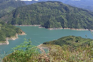
The Alberto Lleras Dam, also known as the Guavio Dam, is a rock-fill embankment dam on the Guavio River near Guavio, Colombia.

The Patía River is a river in southwestern Colombia. It flows over 400 kilometres (250 mi) to drain into the Pacific Ocean north of Tumaco. The Patía River is the longest river on the Colombian Pacific Coast. The last 90 kilometres (56 mi) is navigable by boat.

The Cali River is a river of western Colombia. It flows through the city of Cali and drains into the Cauca River. Its headwaters are in the Farallones de Cali of the Cordillera Occidental.

Lebrija River is a river of northern Colombia. It originates in the Eastern Ranges of the Colombian Andes in Piedecuesta and flows through the northern part of the department of Santander into the Magdalena River in Puerto Wilches.

Sogamoso River is a river of northern Colombia. It flows into the Magdalena River and on to the Caribbean Sea. The Sogamoso Dam on the river near Bucaramanga was completed in 2014.
Carare River is a river of northern Colombia. It flows into the Caribbean Sea.

Nare River is a river of northern Colombia. It flows into the Caribbean Sea.
Batán River is a river of Cundinamarca, Colombia. It is a tributary of the Guavio River, that flows into the Cuja River and later into the Sumapaz River. The Sumapaz River flows into the Magdalena River basin, flowing towards the Caribbean Sea.

Sumapaz Páramo is a large páramo ecosystem located in the Altiplano Cundiboyacense mountain range, considered the largest páramo ecosystem in the world. It was declared a National Park of Colombia in 1977 because of its importance as a biodiversity hotspot and main source of water for the most densely populated area of the country, the Bogotá savanna.

Chingaza National Natural Park is located in the Eastern Ranges of the Colombian Andes, northeast of Bogotá, Colombia in the departments of Cundinamarca and Meta. The elevation in the park, to the east of the Altiplano Cundiboyacense, ranges from 800 metres (2,600 ft) to 4,020 metres (13,190 ft), and the temperature ranges from 4 to 21.5 °C. The park extends over the Cundinamarca municipalities La Calera, Fómeque, Guasca and San Juanito (Meta).
Juan (Francisco) de Céspedes Ruiz was a Spanish conquistador who is known as the founder of the town of Pasca, Cundinamarca, in the south of the Bogotá savanna, Colombia. De Céspedes arrived in the Americas in 1521 and participated in the conquest of the Tairona and the foundation of Santa Marta under Rodrigo de Bastidas. From 1542 to 1543 and in 1546 he served as mayor of Bogotá and after that until 1570 as lieutenant general of the first president of Colombia. Juan de Céspedes married Isabel Romero, one of the first Spanish women who arrived at Colombian territories and had two legitimate sons and one daughter. His date of death is uncertain; in late 1573 or 1576.
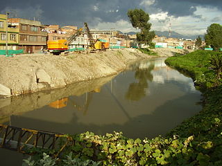
The Tunjuelo or Tunjuelito River is a river on the Bogotá savanna and a left tributary of the Bogotá River. The river, with a length of 73 kilometres (45 mi) originates in the Sumapaz Páramo and flows northward through the Usme Synclinal to enter the Colombian capital Bogotá. There, the river is mostly canalised flowing westward into the Bogotá River. It is one of the three main rivers of the city, together with the Fucha and Juan Amarillo Rivers.

The Sumapaz River is a major tributary of the Magdalena River in Colombia. The 95 kilometres (59 mi) long river originates in the Eastern Ranges of the Colombian Andes at the largest páramo in the world; Sumapaz, of which it takes its name. It forms the natural boundary between the departments of Cundinamarca and Tolima.
The Guavio Formation is a geological formation of the Altiplano Cundiboyacense, Eastern Ranges of the Colombian Andes. The formation consists of conglomerates, shales and limestones, dates to the Late Jurassic and Early Cretaceous periods; Tithonian to Berriasian epochs and has a maximum thickness of 1,000 metres (3,300 ft).

