
Gustavo Rojas Pinilla International Airport is the main airport in the archipelago of San Andrés, Providencia and Santa Catalina, one of the departments of Colombia. It is able to receive large aircraft and to accommodate seasonal and charter flights from different parts of the Americas and Europe.

Alcides Fernández Airport is a commercial airport on the Caribbean coast serving to town of Acandí in the Choco Department of Colombia. The airport is considered by residents of the town of Acandí to be an important link between that community and the rest of Colombia as well as neighboring Panama.
Puerto Bolívar Airport is a private airport in the Guajira Department of Colombia. The closest city is Uribia. It is located next to the Cerrejón coal terminal and only serves the workers of the area. Only private sector aircraft and Colombia's Aerocivil land at Puerto Bolivar. No commercial airlines serve the airport and it is mostly empty.

Santiago Pérez Quiroz Airport (Spanish: Aeropuerto Santiago Pérez Quiroz is an airport serving Arauca, the capital of the Arauca Department in Colombia. The runway is southeast of the city, and 2 kilometres south of Colombia's border with Venezuela.
Guaymaral Airport is a high-elevation airport in the north of Bogotá, Colombia, also serving the towns of Cota and Chía. The runway is 15 kilometres (9.3 mi) northeast of Bogota's El Dorado International Airport.

Guillermo León Valencia Airport is an airport serving Popayán, the capital city of the Cauca Department in Colombia. It took the name of former President of Colombia Guillermo León Valencia Muñoz.

Alfonso López Pumarejo Airport serves as air terminal for the city of Valledupar, Colombia and as a small Colombian Air Force and Colombian Police air base. The airport is operated by Aerocivil and three commercial airlines serve the airport: LAN Colombia, EasyFly and Avianca.
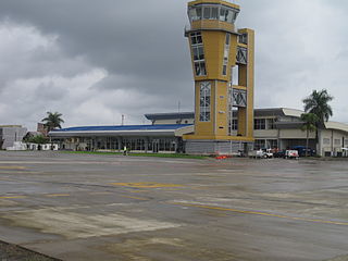
Almirante Padilla Airport is an airport serving the Caribbean coastal city of Riohacha in the Guajira Department of Colombia. It is served by Avianca and formerly by Tiara Air. The airport is on the southwestern edge of the city.
Yariguíes Airport is an airport serving Barrancabermeja, a city in the Santander Department of Colombia. The airport is 6 kilometres (3.7 mi) southeast of the city.
Perales Airport is an airport serving the city of Ibagué in the Tolima Department of Colombia.

Antonio Roldán Betancourt Airport is an airport serving Apartadó, a town in the Antioquia Department of Colombia. The airport is in the countryside 12 kilometres (7.5 mi) southwest of Apartadó.
Guapi Airport, also known as Juan Casiano Airport (Spanish: Aeropuerto "Juan Casiano Solis" de Guapi, is an airport serving Guapi, a municipality in the Cauca Department of Colombia.
Tres de Mayo Airport is an airport serving the town of Puerto Asís in the Putumayo District of Colombia.
César Gaviria Trujillo Airport is an airport serving the town of Inírida in the Guainía Department of Colombia. The airport is named in honor of César Gaviria Trujillo, a former President of Colombia and Secretary General of the Organization of American States.
El Caraño Airport is an airport serving Quibdó in the Chocó Department of Colombia.

Jorge Enrique González Torres Airport is an airport serving San José del Guaviare, the capital of the Guaviare Department of Colombia. The runway is just north of the town and parallels the Guaviare River.
La Florida Airport is an airport serving the Pacific coast city of Tumaco in the Nariño Department of Colombia. The airport is on an island connected to the mainland through a series of bridges.

Santa Ana Airport is an airport serving Cartago, a city in the Valle del Cauca Department of Colombia.
Juanchaco Airport is an airport serving the Pacific coast village of Juanchaco in the Valle del Cauca Department of Colombia.

The Bahía Solano Fault, Utría Fault or Utría-Bahía Solano Fault is a westward dipping thrust fault in the department of Chocó on the Pacific Coast of Colombia. The fault has a total length of 290.6 kilometres (180.6 mi) and runs along an average north-south strike of 347 ± 13 from the Panama-Colombia border to Bajo Baudó. The fault is partly offshore in the bays of Solano and Utría and crosses the Chocó Basin and the coastal Serranía del Baudó. Movement of the fault produced the Mw 6.5 1970 Bahía Solano earthquake.


