Related Research Articles
The Prahova is a river of Southern Romania, which rises from the Bucegi Mountains, in the Southern Carpathians. It flows into the Ialomița near Adâncata. The upper reach of the river, upstream of the confluence with the river Azuga is sometimes called the Prahovița.
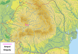
The Ampoi is a river in the Apuseni Mountains, Alba County, western Romania. It is a right tributary of the river Mureș. It flows through the town Zlatna, and joins the Mureș near Alba Iulia. Its length is 43 km (27 mi) and its basin size is 250 km2 (97 sq mi).
The Valea Țiganului is a right tributary of the river Bega in Romania. It discharges into the Bega in Izvin. Its length is 9 km (5.6 mi) and its basin size is 37 km2 (14 sq mi).

The Sălăuța is a right tributary of the river Someșul Mare in Romania. It discharges into the Someșul Mare in Salva. Its length is 44 km (27 mi) and its basin size is 413 km2 (159 sq mi).
The Vasilat is a left tributary of the river Lotru in Romania. It discharges into the Lotru in Valea lui Stan near Brezoi. Its length is 16 km (9.9 mi) and its basin size is 44 km2 (17 sq mi).
The Firiza is a right tributary of the river Săsar in Maramureș County, Romania. It discharges into the Săsar in Baia Mare. Its length is 28 km (17 mi) and its basin size is 168 km2 (65 sq mi). The Strâmtori Dam is built on the river Firiza.
The Brătei is a right tributary of the river Ialomița in Romania. Its source is in the Bucegi Mountains. It flows into the Ialomița in Dobrești. Its length is 14 km (8.7 mi) and its basin size is 55 km2 (21 sq mi).
The Timiș or Timișul Sec is a right tributary of the river Ghimbășel in Romania. Its source is in the Piatra Mare Mountains, northeast of Predeal. It discharges into the Ghimbășel in Sânpetru. It flows through the eastern part of the city Brașov. Its length is 35 km (22 mi) and its basin size is 105 km2 (41 sq mi). Part of its water is diverted towards the Timiș Canal.
The Ghimbășel is a left tributary of the river Bârsa in Romania. Its source is in the northern part of the Bucegi Mountains. Originally it discharged directly into the Olt, but much of its flow has been diverted into the Bârsa, another tributary of the Olt, near Colonia Bod. Its length is 67 km (42 mi) and its basin size is 533 km2 (206 sq mi). The former lower course of the Ghimbășel, downstream of this diversion, still exists and is used for the discharge of local inflows. It flows into the Olt north of Bod. Its length is 6 km (3.7 mi) and its basin size is 8 km2 (3.1 sq mi).

The Valea Cheii is a left tributary of the river Dâmbovița in Romania. Its source is in the Leaota Mountains. It flows into the Dâmbovița downstream from Podu Dâmboviței. Its length is 14 km (8.7 mi) and its basin size is 35 km2 (14 sq mi).
The Săliște is a left tributary of the river Cibin in Romania. It discharges into the Cibin in Orlat. Its length is 32 km (20 mi) and its basin size is 220 km2 (85 sq mi).
The Izvorul Dorului is a right tributary of the river Prahova in Romania. It discharges into the Prahova in Sinaia. Its length is 16 km (9.9 mi) and its basin size is 33 km2 (13 sq mi).
The Dâmbovicioara is a left tributary of the river Dâmbovița in Romania. Its source is in the Piatra Craiului Mountains. It flows into the Dâmbovița in Podu Dâmboviței. Its length is 13 km (8.1 mi) and its basin size is 47 km2 (18 sq mi). Upstream from its confluence with the Valea cu Apă it is also called Valea Seacă a Pietrelor, and between the confluences with the Valea cu Apă and Valea Muierii it is also called Brusturet.

The Sadu is a right tributary of the river Cibin in Romania. It discharges into the Cibin in Tălmaciu. The Negovanu and Sadu II dams are located on the Sadu. Its length is 60 km (37 mi) and its basin size is 278 km2 (107 sq mi).
The Iza is a left tributary of the river Tisa in northern Romania. Its source is in the Rodna Mountains. It flows into the Tisa near the city Sighetu Marmației. It passes through the communes Săcel, Săliștea de Sus, Dragomirești, Bogdan Vodă, Șieu, Rozavlea, Strâmtura, Bârsana, Oncești, Vadu Izei, and Sighetu Marmației. Its drainage basin covers an area of 1,293 km2 (499 sq mi). Its length is 80 km (50 mi).
The Cheia is a right tributary of the river Olănești in Romania. It flows into the Olănești in Valea Cheii. Its length is 25 km (16 mi) and its basin size is 80 km2 (31 sq mi).
The Bistra Mărului is a left tributary of the river Bistra in Romania. It discharges into the Bistra in Oțelu Roșu. Its length is 35 km (22 mi) and its basin size is 293 km2 (113 sq mi).
The Sebeș is a left tributary of the river Olt in Romania. It discharges into the Olt east of Făgăraș. Its source is in the Făgăraș Mountains. Its length is 38 km (24 mi) and its basin size is 94 km2 (36 sq mi).
The Topa is a right tributary of the river Holod in Romania. It flows into the Holod near Rogoz. Its length is 38 km (24 mi) and its basin size is 276 km2 (107 sq mi).
The Valea Luncanilor is a right tributary of the river Strei in Romania. It discharges into the Strei in Streisângeorgiu. Its length is 27 km (17 mi) and its basin size is 148 km2 (57 sq mi).
References
- ↑ "Planul național de management. Sinteza planurilor de management la nivel de bazine/spații hidrografice, anexa 7.1" (PDF, 5.1 MB). Administrația Națională Apele Române. 2010. p. 494.
- 1 2 Atlasul cadastrului apelor din România. Partea 1 (in Romanian). Bucharest: Ministerul Mediului. 1992. p. 202. OCLC 895459847. River code: V.1.18.1
| This article related to a river in Timiș County is a stub. You can help Wikipedia by expanding it. |