Currin Bridge | |
---|---|
Coordinates | 43°47′37″N122°59′43″W / 43.79361°N 122.99528°W |
Carries | Pedestrians |
Crosses | Row River |
Other name(s) | Row River Covered Bridge |
Characteristics | |
Design | Covered |
Total length | 105 feet (32 m) |
History | |
Construction end | 1925 |
Closed | 1979 |
Currin Bridge | |
Nearest city | Cottage Grove, Oregon |
Area | 0.2 acres (0.08 ha) |
Built | 1925 |
Architectural style | Howe Truss |
MPS | Oregon Covered Bridges TR |
NRHP reference No. | 79002082 [1] |
Added to NRHP | November 29, 1979 |
Location | |
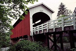
The Currin Bridge is a Howe truss covered bridge near Cottage Grove, Oregon, United States. It crosses the Row River.
The Currin Bridge was built in 1925 to replace another bridge built in 1883. The lowest bid received by Lane County for construction of the bridge was $6,250, so the county decided to build the bridge on its own for $4,205, saving $2,495 of taxpayers' money. The bridge was named after an early pioneer family. [2] [3]
The Currin Bridge is the only bridge in Oregon that is painted two different colors. The Currin Bridge has white portals and red sides. [4] It is one of seven covered bridges in the immediate area. [5]
In 1979, Lane County completed a new concrete bridge nearby the Currin Bridge and closed the old bridge to traffic. The new bridge is only a few feet away from the Currin Bridge, which is still accessible by pedestrians. In 1987, the bridge had work done fumigating for insects and structural repair, and in 1993–1995, the Oregon Covered Bridge Program of Lane County received a grant of $48,000 to restore the bridge. [2] The bridge was added to the National Register of Historic Places in 1979. [1]
Dexter is an unincorporated community and census-designated place (CDP) in Lane County, Oregon, United States. It is located near Dexter Reservoir, a.k.a. Dexter Lake, a reservoir of the Middle Fork Willamette River along Oregon Route 58.
The Ada Covered Bridge is a 125-foot (38 m) span Brown truss covered bridge erected in 1867 in Ada, Michigan, United States. Carrying Bronson Street across the Thornapple River, it is located just south of where the Thornapple enters the Grand River, in turn just south of M-21. It is listed on the National Register of Historic Places.
Sheridan Bridge is a two-lane steel Truss bridge carrying vehicular traffic in Sheridan, Oregon, United States. Construction began in 1938 and finished in 1939. This 258-foot (79 m) bridge connects the northern and southern portions of the town across the South Yamhill River in Yamhill County.
The Office Bridge is a covered bridge in Westfir, Lane County, Oregon, U.S. crossing the North Fork Middle Fork Willamette River at the south end of the Aufderheide National Scenic Byway and edge of the Willamette National Forest. It is Oregon's longest covered bridge at 180 ft, and is one of only two in the state using triple Howe truss construction. It is the only covered bridge west of the Mississippi River which has a separate pedestrian walkway.
The Belknap Bridge crosses the McKenzie River near the unincorporated community of Rainbow in Lane County, Oregon, United States. It is approximately three miles west of the town of McKenzie Bridge which is named after the bridge. It is the fourth covered bridge built on the site. The bridge is well maintained and open to traffic. The Belknap Bridge is listed on the National Register of Historic Places.
The Goodpasture Bridge spans the McKenzie River near the community of Vida in Lane County, Oregon, United States. It is the second longest covered bridge and one of the most photographed covered bridges in the state. The Goodpasture Bridge is listed on the National Register of Historic Places.
The Chambers Covered Bridge is a covered bridge located in Cottage Grove, Oregon, United States. It is 78 feet (24 m) long and spans the Coast Fork Willamette River. It was built in 1925 to carry rail traffic hauling logs from the Lorane Valley to the J.H. Chambers Mill, a lumber mill which was located on an area between South Highway 99 and the Coast Fork Willamette River. The mill closed in the 1950s after a second fire burned the mill down. The railroad tracks were removed and the bridge was left. The mill property is now being developed as a housing development called Riverwalk. The Chambers Covered Railroad Bridge is the only remaining fully covered railroad bridge west of the Mississippi River.
Wildcat Creek Bridge is a covered bridge built in 1925 at Austa, near Walton, in the U.S. state of Oregon. It uses Howe truss engineering and was listed on the National Register of Historic Places in 1979. The 75-foot (23 m) bridge carries Austa Road over Wildcat Creek near its confluence with the Siuslaw River.
Unity Bridge is an historic 90-foot (27 m) long covered bridge over Fall Creek at Unity near Lowell in Lane County, Oregon, United States. Also known as Unity Covered Bridge and Unity Creek Bridge, it was built in 1936 at a cost $4,400 by Lane County using the Howe truss system. Its east side features a full-length window with its own roof so that drivers can see oncoming cars.
The Mosby Creek Bridge, also called the Layng Bridge, is a historic Howe truss covered bridge located near Cottage Grove, Oregon, United States. The bridge crosses Mosby Creek and was constructed in 1920, making it the oldest covered bridge in Lane County.
Lowell Bridge is a covered bridge in Lowell, Oregon, United States. The original bridge was built in 1907. The current bridge was built in 1945. It was listed on the National Register of Historic Places in 1979.
The Pengra Bridge is a covered bridge near Jasper in the U.S. state of Oregon. The 120-foot (37 m) Howe truss structure carries Place Road over Fall Creek in Lane County. It replaced an earlier bridge, built in 1904, that crossed the creek a few feet further upstream.
The Deadwood Creek Bridge is a covered bridge in western Lane County in the U.S. state of Oregon. Built in 1932, the 105-foot (32 m) Howe truss structure carries Deadwood Loop Road over Deadwood Creek. The crossing lies upstream of the rural community of Deadwood in the Siuslaw National Forest of the Central Oregon Coast Range. The bridge was added to the National Register of Historic Places in 1979.
The Wendling Bridge is a covered bridge in Lane County in the U.S. state of Oregon. The 60-foot (18 m) Howe truss structure carries Wendling Road over Mill Creek in the unincorporated community of Wendling. Built in 1938, the bridge was added to the National Register of Historic Places in 1979.
The Milo Academy Bridge is a covered bridge located in the town of Milo, in the southern region of Douglas County, Oregon. The original bridge at this location was a wooden covered bridge constructed in 1920, before being replaced by a steel truss bridge in 1962, spanning the South Umpqua River allowing access to Milo Adventist Academy. The bridge was added to the National Register of Historic Places November 29, 1979.
The Corbin Covered Bridge is a wooden covered bridge over the North Branch of the Sugar River on Corbin Road, approximately 1 mile (1.6 km) west of NH 10 in Newport in Sullivan County, New Hampshire, United States. The bridge was listed on the National Register of Historic Places in 1976, but was removed following its destruction by fire in the early hours of May 25, 1993. It has since been reconstructed.
The Horse Creek Bridge was a covered bridge near the unincorporated community of McKenzie Bridge in Lane County in the U.S. state of Oregon. Built in 1930, the structure, 105 feet (32 m) long, carried Horse Creek Road over Horse Creek. The creek is a tributary of the McKenzie River.
The Brumbaugh Bridge was a covered bridge in Lane County in the U.S. state of Oregon. Built in 1948, the structure originally carried Row River Road over Mosby Creek near Cottage Grove. It was added to the National Register of Historic Places in 1979 and was subsequently delisted.