
Mediterranean tropical-like cyclones, often referred to as Mediterranean cyclones or Mediterranean hurricanes, and informally as medicanes, are meteorological phenomena occasionally observed over the Mediterranean Sea. On a few rare occasions, some storms have been observed reaching the strength of a Category 1 hurricane, on the Saffir–Simpson scale, and a storm in 2020 was recorded reaching Category 2 intensity. The main societal hazard posed by medicanes is not usually from destructive winds, but through life-threatening torrential rains and flash floods.

Tropical Storm Rolf, also known as Tropical Storm 01M, was an unusual Mediterranean tropical storm that brought flooding to Italy, France, Spain, and Switzerland in November 2011. Rolf originated from an extratropical system near western France on 4 November. Despite the generally unfavorable conditions in the Mediterranean Sea, Rolf transitioned into a subtropical depression on 7 November, before becoming a tropical storm later that day. On 8 November, Rolf reached its peak intensity, with 1-minute sustained winds peaking at 85 km/h (53 mph) and a minimum central pressure of 991 mb (29.3 inHg). During the next day, the storm made landfall on the island of Île du Levant, in France, and soon afterward, near Hyères in southeastern France. Following its second landfall, Rolf quickly weakened and dissipated on 10 November. Rolf was the first tropical cyclone ever to be officially monitored by the NOAA in the Mediterranean Sea.

Cyclone Qendresa, also known as Medicane Qendresa, was one of the most intense Mediterranean tropical-like cyclones on record, which struck Malta and the Italian island of Sicily in 2014. The storm formed on 5 November and rapidly intensified two days later, reaching peak intensity on 7 November, due to a cold-core low aloft. Qendresa directly hit Malta in the afternoon and then crossed the eastern coast of Sicily on 8 November. Later, the cyclone weakened significantly and dissipated over Crete on 11 November. Academic sources indicate that Qendresa transitioned into a subtropical cyclone, prior to reaching peak intensity. Qendresa caused three fatalities, and at least $250 million in damages in Italy.
The 2017–2018 European windstorm season was the third instance of seasonal European windstorm naming. France, Spain and Portugal took part in winter storm naming for the first time this season.

Cyclone Julia brought heavy flooding and hurricane conditions to parts of Europe, the Mediterranean region, and North Africa in February 2012. The second tropical or subtropical cyclone, second named storm, and the strongest storm of the 2011–12 Mediterranean hurricane season, Julia originated from an extratropical system that split off from its parent storm, in the western Mediterranean Sea on February 2. Despite the unfavorable conditions in the Mediterranean Sea, Julia strengthened into a powerful subtropical cyclone, with winds peaking at 61 mph (98 km/h), and a minimum pressure of 982 mbar (29.0 inHg) on February 6. On February 7, the storm made landfall on the Peloponnesian Peninsula, and eventually dissipated over Turkey. Cyclone Julia caused at least $6.4 million in damages, and resulted in at least 12 deaths. The storm also worsened the effects of the Early 2012 European cold wave across Europe and North Africa.

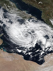
Cyclone Numa, also known as Medicane Numa, was a Mediterranean tropical-like cyclone with the properties of a subtropical cyclone. Numa formed on 11 November 2017 west of the British Isles, out of the extratropical remnants of Tropical Storm Rina, the seventeenth named storm of the 2017 Atlantic hurricane season. Subsequently, on 17 November, Numa acquired subtropical characteristics before reaching peak intensity on 18 November, becoming a rare "medicane". After making landfall in Greece on 18 November, Numa rapidly weakened, and was later absorbed into another extratropical storm on 20 November. The flooding triggered by Numa became the worst weather event Greece had experienced since 1977, and the storm caused an estimated $100 million in damages in Europe.

The 2018–19 South-West Indian Ocean cyclone season was the costliest and the most active season ever recorded since reliable records began in 1967. Additionally, it is also the deadliest cyclone season recorded in the South-West Indian Ocean, surpassing the 1891–92 season in which the 1892 Mauritius cyclone devastated the island of Mauritius. The season was an event of the annual cycle of tropical cyclone and subtropical cyclone formation in the South-West Indian Ocean basin. It officially began on 15 November 2018, and ended on 30 April 2019, except for Mauritius and the Seychelles, which it ended on 15 May 2019. These dates conventionally delimit the period of each year when most tropical and subtropical cyclones form in the basin, which is west of 90°E and south of the Equator. Tropical and subtropical cyclones in this basin are monitored by the Regional Specialised Meteorological Centre in Réunion.
The 2018–2019 European windstorm season was the fourth instance of seasonal European windstorm naming in Europe. Most storms form between September and March. The first named storm, Ali, affected primarily the United Kingdom and Ireland on 19 September 2018.

The 2019–20 European windstorm season was the fifth instance of seasonal European windstorm naming in Europe. This is the first season in which the Netherlands participates, joining Ireland's and the United Kingdom's meteorological agencies. The new season's storm names were released on 6 September 2019. In July 2019, it was announced that storm seasons would run from 1 September 2019 to 1 September 2020. The Portuguese, Spanish and French meteorological agencies again collaborated too, joined by the Belgian meteorological agency.

The 2020–21 South-West Indian Ocean cyclone season was an above-average season which produced 12 named storms, with 7 strengthening into tropical cyclones. The season started with the formation of Cyclone Alicia in the extreme northeast section of the basin on 12 November 2020, just before the official start of the season, which marked the third season in a row in which a tropical cyclone formed before the official start of the season. It officially began on 15 November 2020, and ended with the dissipation of Cyclone Jobo on 24 April, 6 days before the official end on 30 April 2021, with the exception of Mauritius and the Seychelles, which officially ended on 15 May 2021. These dates conventionally delimit the period of each year when most tropical and subtropical cyclones form in the basin, which is west of 90°E and south of the Equator. Tropical and subtropical cyclones in this basin are monitored by the Regional Specialised Meteorological Centre in Réunion and unofficially by the Joint Typhoon Warning Center.
The 2020–2021 European windstorm season was the sixth instance of seasonal European windstorm naming in Europe. This is the second season in which the Netherlands participates, joining Ireland's and the United Kingdom's meteorological agencies. The new season's storm names were released on 1 September 2020. Storms that occur up until 31 August 2021 will be included in this season. The Portuguese, Spanish, and French meteorological agencies will again collaborate too, joined by the Belgian meteorological agency.
Cyclone Ianos, also known as Medicane Ianos, was a rare medicane that impacted the eastern Mediterranean on 17 and 18 September 2020, especially Greece. Ianos developed from an area of low pressure over the Gulf of Sidra that quickly began tropical cyclogenesis while moving over warm waters. After receiving various names from different meteorological centers, the storm, dubbed Ianos by the METEO unit of the National Observatory of Athens, rapidly intensified while moving northeastward. After scraping Italy, the storm went on to strike Malta and Crete with tropical storm-force winds. Despite land interaction, the small cyclone reached its peak intensity of 159 km/h (99 mph) with wind gusts up to 195 km/h (121 mph) on 18 September, equivalent to a Category 2 hurricane on the Saffir–Simpson scale, immediately before making landfall in southwestern Greece. After landfall, Ianos turned back out to sea and moved south-southeastward, before dissipating on 21 September.

Cyclone Zorbas, or Medicane Zorbas, was the first officially documented Mediterranean tropical-like cyclone, or medicane, since Cyclone Numa in 2017. Zorbas originated as an extratropical cyclone in the eastern Mediterranean Sea. Warm sea surface temperatures allowed the system to quickly deepen and transition into a tropical cyclone. Zorbas intensified as it headed northward towards Greece, finally reaching its peak intensity with maximum sustained winds of 120 km/h (75 mph) and a minimum central pressure of 987 mbar (29.15 inHg) on September 29.

During 1996, tropical cyclones formed within seven different tropical cyclone basins, located within various parts of the Atlantic, Pacific, and Indian Oceans. During the year, a total of 139 tropical cyclones formed in bodies of water known as tropical cyclone basins. 90 of them were named by various weather agencies when they attained maximum sustained windS of 35 knots. The strongest tropical cyclone of the year was Cyclone Daniella, peaking with a pressure of 915 hPa (27.02 inHg) in the open waters of the Indian Ocean. Hurricane Fran and Typhoon Herb tie for the costliest storm of the year, both with a damage cost of $5 billion. The deadliest tropical cyclone of the year was the 1996 Andhra Pradesh cyclone, which was blamed for over 1,000 fatalities as it directly affected the state of Andhra Pradesh in India. Five Category 5 tropical cyclones were formed in 1996. The accumulated cyclone energy (ACE) index for the 1996, as calculated by Colorado State University was 960 units.

The 2021–22 European windstorm season was the seventh instance of seasonal European windstorm naming in Europe. This was the third season in which the Netherlands participated, alongside the meteorological agencies of Ireland and the United Kingdom. The season's storm names were released on 1 September 2021. Storms that occurred up until 31 August 2022 were included in this season. The Portuguese, Spanish, French and Belgian meteorological agencies collaborated again, for the fifth time, joined by the Luxembourg meteorological agency. This was the first season when Greece, Israel and Cyprus, and Italy, Slovenia, Croatia, Montenegro, North Macedonia and Malta named storms which affected their areas.

Storm Athina was an early extratropical cyclone that was most notable for its damages it brought to Greece and Italy during early-October 2021. The first storm to be officially named in conjunction with the naming list of the former, Israel and Cyprus, Athina formed on 6 October over central Italy before taking an erratic track across the country and into the Ionian Sea, until near Albania and Greece. It then slowly weakened before it dissipated on 11 October as it moved over the latter and emerging into the Aegean Sea. The Free University of Berlin tracked the system as Christian into its initial and dissipating stages.

Storm Blas was a small extratropical cyclone and Mediterranean tropical-like cyclone that caused devastation and disruption across the Balearic Islands, Spain, France, and Italy during early and mid-November 2021. The storm was named by Agencia Estatal de Meteorología (AEMET) on 5 November, with the agency issuing wind and rain alerts to the Balearic archipelago and other areas reaching the eastern coasts of Spain, as Blas approached from the east. It then turned eastward after moving slowly westward, and the storm meandered across the western Mediterranean for the next several days, before eventually dissipating to the west of Italy on 18 November.

The 2022–23 European windstorm season is both the deadliest and costliest European windstorm season on record. The most notable system of the season was Storm Daniel, which became the deadliest and costliest medicane ever recorded and the deadliest tropical or subtropical system worldwide since at least 2008.
