
The Berwyn range is an isolated and sparsely populated area of moorland in the northeast of Wales, roughly bounded by Llangollen in the northeast, Corwen in the northwest, Bala in the southwest, and Oswestry in the southeast.

Aran Fawddwy is a mountain in southern Snowdonia, Wales, United Kingdom. It is the highest point of the historic county of Merionethshire. It is the highest peak in the Aran mountain range, the only peak in Wales outside North Snowdonia above 900m, and higher than anywhere in the United Kingdom outside Northern Snowdonia, the Scottish Highlands and the Lake District. The nearest small settlements to the mountain are Dinas Mawddwy to the south, Llanymawddwy to the southeast, Llanuwchllyn on the shores of Bala Lake to the north, and Rhydymain to the west. The nearest settlements with around 2,000 people are Bala and Dolgellau. On the eastern slopes of Aran Fawddwy is the small lake named Creiglyn Dyfi, the source of the River Dyfi. Its sister peak is Aran Benllyn at 885 metres (2,904 ft). There is also a middle peak: Erw y Ddafad-ddu.

Cadair Idris or Cader Idris is a mountain in the Meirionnydd area of Gwynedd, Wales. It lies at the southern end of the Snowdonia National Park near the town of Dolgellau. The peak, which is one of the most popular in Wales for walkers and hikers, is composed largely of Ordovician igneous rocks, with classic glacial erosion features such as cwms, moraines, striated rocks, and roches moutonnées.
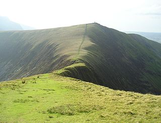
Cadair Berwyn, Cader Berwyn or Craig Uchaf is a mountain summit in north-east Wales with a height of 832 metres (2,730 ft) above sea level. It is the highest point in the Berwyn range, the highest in North East Wales and the highest significant summit in Wales outside the National Parks. Cadair Berwyn and Foel Cedig to the west are the two Marilyns that form the Berwyn range. The undulating plateau of the range also includes a large number of other summits above 2,000 feet (610 m), including satellite summits of Cadair Berwyn and many which are classed as Nuttalls.

Bwlch y Groes is the second highest public road mountain pass in Wales, with a summit altitude of 545 metres (1,788 ft). Gospel Pass in south Wales is slightly higher. It lies on minor roads linking Dinas Mawddwy, Llanuwchllyn and Lake Vyrnwy. The view from the pass encompasses the plain of the Dyfi valley, Cadair Idris and a close view of Aran Fawddwy. The cross, just below the summit at the junction of the roads from Vyrnwy and from Dinas Mawddwy, commemorates the place of the pass on a pilgrim route from north Wales.
Foel Wen is a subsidiary summit of Cadair Berwyn in north east Wales. It is one of the summits found on the most easterly of Cadair Berwyn's long south ridges.

Mynydd Tarw is a subsidiary summit of Cadair Berwyn in north east Wales. It used to have a top: Rhos which has now been deleted as a Nuttall.

Godor is a top of Cadair Berwyn in north east Wales. It lies as the last summit on a boggy ridge heading south from Cadair Berwyn's summit. The summits of Tomle and Godor North Top are also to be found on the ridge.

Tomle is a top of Cadair Berwyn in north east Wales. It is the highest of the summits found on the most easterly of Cadair Berwyn's long south ridges.

Aran Benllyn is a subsidiary summit of Aran Fawddwy in southern Snowdonia, North Wales, Wales, United Kingdom. It is the second highest peak in the Aran mountain range.

Mynydd Moel is the second highest summit of Cadair Idris in the Snowdonia National Park, in Gwynedd, northwest Wales.

Gau Graig is a subsidiary summit of Cadair Idris in the Snowdonia National Park, in Gwynedd, northwest Wales. It lies to the east of Mynydd Moel on a broad grassy plateau. It marks the eastern end of the Cadair Idris ridge.

Tyrrau Mawr or Craig-las is a subsidiary summit of Cadair Idris in the Snowdonia National Park, in Gwynedd, northwest Wales. It lies to the west of Cyfrwy, and can be climbed by taking a west bearing from the Pony Path at Rhiw Gwredydd. Its north face is a crag, known as Craig-las. Below the crags lies Llyn Cregennen with its small island. The reflection of Craig-las from this lake is one of the famous images associated with Snowdonia.

The Milltir Cerrig is a mountain pass in Wales, on the B4391 between Bala and Llangynog (Powys), briefly passing through Denbighshire.

The River Dysynni is a river in mid Wales. Its source is the Tal-y-llyn Lake just south of the Cadair Idris massif and its mouth is in the Cardigan Bay area of the Irish Sea to the north of Tywyn. It measures about 16 mi (26 km) in length.

Glasgwm is a mountain in Gwynedd, Wales forming part of the Aran range in southern Snowdonia. It is one of the three Marilyns that make up the range, the others being Aran Fawddwy and Esgeiriau Gwynion. To the west is Maesglase and the Dyfi hills, while to the south-west lies Cadair Idris. To the south lies the Plynlimon range. It is 779 metres (2,556 ft) high.

Tarren y Gesail is a mountain in Snowdonia, north Wales. It is one of the Marilyns of the Cadair Idris group.
Mynydd Tal-y-Mignedd is a peak on the Nantlle Ridge in Snowdonia, north Wales. It is located at the centre of the ridge, and is a subsidiary summit of Trum y Ddysgl.

Post Gwyn is a subsidiary summit of Cadair Berwyn in north east Wales. It is the western outpost of the main central Berwyn range. The range also includes the Hirnantau to the west, which are crowned by Cyrniau Nod.

Craig-y-llyn is a subsidiary summit of Cadair Idris in the Snowdonia National Park, in Gwynedd, northwest Wales. It lies at the western end of the long Cadair Idris ridge. Its north-facing cwm houses the small glacial lake, Llyn Cyri. The southern flanks have gentle slopes, while the northern are very steep and contain broken crags.
