Łucka-Kolonia is a village in the administrative district of Gmina Lubartów, within Lubartów County, Lublin Voivodeship, in eastern Poland.
Malharrao is a mandal in Jayashankar Bhupalpally district of the Telangana state in India.

Jagielnica is a village in the administrative district of Gmina Przeworno, within Strzelin County, Lower Silesian Voivodeship, in south-western Poland. The village was founded by residents of another Jagielnica, now in western Ukraine, fleeing the onset of World War II. The territory belonged to Poland prior to 1939, and prior to 1945 it was in Germany.

Zamczyska is a village in the administrative district of Gmina Warlubie, within Świecie County, Kuyavian-Pomeranian Voivodeship, in north-central Poland. It lies approximately 10 kilometres (6 mi) north-west of Warlubie, 26 km (16 mi) north of Świecie, 68 km (42 mi) north-east of Bydgoszcz, and 69 km (43 mi) north of Toruń.
Lubierzyn is a village in the administrative district of Gmina Tuchola, within Tuchola County, Kuyavian-Pomeranian Voivodeship, in north-central Poland.

Kuźnica, formerly Kuźnica Białostocka, is a village in Sokółka County, Podlaskie Voivodeship, in north-eastern Poland, close to the border with Belarus. It is the seat of the gmina called Gmina Kuźnica. It lies approximately 16 kilometres (10 mi) north-east of Sokółka and 54 km (34 mi) north-east of the regional capital Białystok.

Həyat is a village in the Kalbajar Rayon of Azerbaijan.

Leniszki is a village in the administrative district of Gmina Czarnożyły, within Wieluń County, Łódź Voivodeship, in central Poland. It lies approximately 3 kilometres (2 mi) north of Czarnożyły, 10 km (6 mi) north of Wieluń, and 83 km (52 mi) south-west of the regional capital Łódź.
Kolonia Stary Ratyniec is a village in the administrative district of Gmina Sterdyń, within Sokołów County, Masovian Voivodeship, in east-central Poland.

Kąty-Wielgi is a village in the administrative district of Gmina Strachówka, within Wołomin County, Masovian Voivodeship, in east-central Poland.
Bagrianwala is a town and union council of Gujrat District, in the Punjab province of Pakistan. It is part of Kharian Tehsil and is located at 32°33'0N 73°52'0E with an altitude of 217 metres.

Trzebin is a village in the administrative district of Gmina Dobrzyca, within Pleszew County, Greater Poland Voivodeship, in west-central Poland. It lies approximately 4 kilometres (2 mi) west of Dobrzyca, 17 km (11 mi) west of Pleszew, and 74 km (46 mi) south-east of the regional capital Poznań.
Borownik is a village in the administrative district of Gmina Obrzycko, within Szamotuły County, Greater Poland Voivodeship, in west-central Poland.

Kamień Mały is a village in the administrative district of Gmina Witnica, within Gorzów County, Lubusz Voivodeship, in western Poland. It lies approximately 9 kilometres (6 mi) south-west of Witnica and 34 km (21 mi) west of Gorzów Wielkopolski.

Kozołęka is a settlement in the administrative district of Gmina Nowa Wieś Lęborska, within Lębork County, Pomeranian Voivodeship, in northern Poland. It lies approximately 7 kilometres (4 mi) north-west of Nowa Wieś Lęborska, 9 km (6 mi) north-west of Lębork, and 69 km (43 mi) west of the regional capital Gdańsk.

Najmusy is a settlement in the administrative district of Gmina Starogard Gdański, within Starogard County, Pomeranian Voivodeship, in northern Poland. It lies approximately 8 kilometres (5 mi) east of Starogard Gdański and 43 km (27 mi) south of the regional capital Gdańsk.

Skolwity is a village in the administrative district of Gmina Stary Dzierzgoń, within Sztum County, Pomeranian Voivodeship, in northern Poland. It lies approximately 15 kilometres (9 mi) north-east of Stary Dzierzgoń, 34 km (21 mi) east of Sztum, and 77 km (48 mi) south-east of the regional capital Gdańsk.

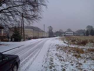
Meszne is a village in the administrative district of Gmina Łobez, within Łobez County, West Pomeranian Voivodeship, in north-western Poland. It lies approximately 7 kilometres (4 mi) west of Łobez and 67 km (42 mi) east of the regional capital Szczecin.

Drzeńsko is a village in the administrative district of Gmina Malechowo, within Sławno County, West Pomeranian Voivodeship, in north-western Poland. It lies approximately 12 kilometres (7 mi) south-east of Malechowo, 15 km (9 mi) south of Sławno, and 164 km (102 mi) north-east of the regional capital Szczecin.

Qiaoxiang station is a Metro station of Shenzhen Metro Line 2. It opened on 28 June 2011. It is located nearby the Qiaoxiang Road.


