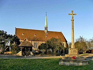
Bayford is a village and civil parish in the East Hertfordshire district of Hertfordshire, England. According to the 2001 census it had a population of 435, increasing to 466 at the 2011 Census. The village is about three miles south of Hertford, and is served by Bayford railway station.

Marl-Chemiepark Power Station is an ensemble of three thermal power stations. One of these power stations has a 300 meters tall, another a 241 meters tall chimney.

Újszentmargita is a village in Hajdú-Bihar county, in the Northern Great Plain region of eastern Hungary.
Masovia Governorate was an administrative unit (governorate) of the Congress Poland.

Jarząbkowice is a village in the administrative district of Gmina Kostomłoty, within Środa Śląska County, Lower Silesian Voivodeship, in south-western Poland. Prior to 1945 it was in Germany.
Biedaszków Mały is a village in the administrative district of Gmina Trzebnica, within Trzebnica County, Lower Silesian Voivodeship, in south-western Poland. Prior to 1945 it was in Germany.
Jaszyce is a village in the administrative district of Gmina Trzebnica, within Trzebnica County, Lower Silesian Voivodeship, in south-western Poland. Prior to 1945 it was in Germany.

Kaw Township is a township in Jefferson County, Kansas, USA.
Antoniówka is a village in the administrative district of Gmina Sławno, within Opoczno County, Łódź Voivodeship, in central Poland. It lies approximately 3 kilometres (2 mi) north-east of Sławno, 9 km (6 mi) west of Opoczno, and 64 km (40 mi) south-east of the regional capital Łódź.
Bobrowniki is a village in the administrative district of Gmina Działoszyn, within Pajęczno County, Łódź Voivodeship, in central Poland. It lies approximately 7 kilometres (4 mi) west of Działoszyn, 17 km (11 mi) west of Pajęczno, and 90 km (56 mi) south-west of the regional capital Łódź.
Józefów is a village in the administrative district of Gmina Kodrąb, within Radomsko County, Łódź Voivodeship, in central Poland. It lies approximately 3 kilometres (2 mi) east of Kodrąb, 16 km (10 mi) east of Radomsko, and 77 km (48 mi) south of the regional capital Łódź.
Rzędków is a village in the administrative district of Gmina Nowy Kawęczyn, within Skierniewice County, Łódź Voivodeship, in central Poland. It lies approximately 7 kilometres (4 mi) west of Nowy Kawęczyn, 9 km (6 mi) south of Skierniewice, and 49 km (30 mi) east of the regional capital Łódź.
Łochów Stary is a village in the administrative district of Gmina Żelechlinek, within Tomaszów Mazowiecki County, Łódź Voivodeship, in central Poland. It lies approximately 6 kilometres (4 mi) north-east of Żelechlinek, 26 km (16 mi) north of Tomaszów Mazowiecki, and 45 km (28 mi) east of the regional capital Łódź.
Smyków is a village in the administrative district of Gmina Fałków, within Końskie County, Świętokrzyskie Voivodeship, in south-central Poland. It lies approximately 8 kilometres (5 mi) south-west of Fałków, 31 km (19 mi) west of Końskie, and 49 km (30 mi) north-west of the regional capital Kielce.
Pułazie is a village in the administrative district of Gmina Zaręby Kościelne, within Ostrów Mazowiecka County, Masovian Voivodeship, in east-central Poland.
Rawy-Gaczkowo is a village in the administrative district of Gmina Zaręby Kościelne, within Ostrów Mazowiecka County, Masovian Voivodeship, in east-central Poland.
Stok Lacki-Folwark is a village in the administrative district of Gmina Siedlce, within Siedlce County, Masovian Voivodeship, in east-central Poland.
Łódź is a village in the administrative district of Gmina Piaski, within Gostyń County, Greater Poland Voivodeship, in west-central Poland. It lies approximately 6 kilometres (4 mi) south of Piaski, 8 km (5 mi) south-east of Gostyń, and 64 km (40 mi) south of the regional capital Poznań.
Spokojna is a village in the administrative district of Gmina Sława, within Wschowa County, Lubusz Voivodeship, in western Poland.
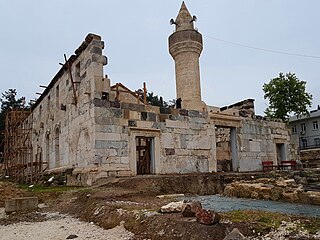
Ala Mosque is a historical mosque in Kadirli, Turkey.


