Gmina Poniatowa

Last updated
Gmina Poniatowa
Poniatowa Commune
Gmina
POL Poniatowa COA.svg
Coat of arms
Coordinates(Poniatowa): 51°11′N22°4′E / 51.183°N 22.067°E / 51.183; 22.067 Coordinates: 51°11′N22°4′E / 51.183°N 22.067°E / 51.183; 22.067
CountryFlag of Poland.svg  Poland
Voivodeship Lublin
County Opole Lubelskie
Seat Poniatowa
Area
  Total 84.16 km2 (32.49 sq mi)
Population (2015 [1] )
  Total 14,630
  Density 170/km2 (450/sq mi)
   Urban 9,495
  Rural 5,135
Website https://web.archive.org/web/20070315201301/http://www.umponiatowa.pl/

Gmina Poniatowa is an urban-rural gmina (administrative district) in Opole Lubelskie County, Lublin Voivodeship, in eastern Poland. Its seat is the town of Poniatowa, which lies approximately 8 kilometres (5 mi) north-east of Opole Lubelskie and 36 km (22 mi) west of the regional capital Lublin.

Gmina administrative division of Poland

The gmina is the principal unit of the administrative division of Poland, similar to a municipality. As of 2010 there were 2,478 gminy throughout the country. The word gmina derives from the German word Gemeinde, meaning "community".
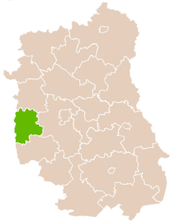
Opole Lubelskie County County in Lublin, Poland

Opole Lubelskie County is a unit of territorial administration and local government (powiat) in Lublin Voivodeship, eastern Poland. It was established on January 1, 1999, as a result of the Polish local government reforms passed in 1998. Its administrative seat is the town of Opole Lubelskie, which lies 44 kilometres (27 mi) west of the regional capital Lublin. The only other town in the county is Poniatowa, lying 8 km (5 mi) north-east of Opole Lubelskie.

Lublin Voivodeship Voivodeship in Poland

Lublin Voivodeship, or Lublin Province, is a voivodeship, or province, located in southeastern Poland. It was created on January 1, 1999, out of the former Lublin, Chełm, Zamość, Biała Podlaska and (partially) Tarnobrzeg and Siedlce Voivodeships, pursuant to Polish local government reforms adopted in 1998. The province is named after its largest city and regional capital, Lublin, and its territory is made of four historical lands: the western part of the voivodeship, with Lublin itself, belongs to Lesser Poland, the eastern part of Lublin Area belongs to Red Ruthenia, and the northeast belongs to Polesie and Podlasie.

Contents

The gmina covers an area of 84.16 square kilometres (32.5 sq mi), and as of 2006 its total population is 15,146 (out of which the population of Poniatowa amounts to 9,911, and the population of the rural part of the gmina is 5,235).

Villages

Apart from the town of Poniatowa, Gmina Poniatowa contains the villages and settlements of Dąbrowa Wronowska, Henin, Kocianów, Kowala Druga, Kowala Pierwsza, Kraczewice Prywatne, Kraczewice Rządowe, Niezabitów, Niezabitów-Kolonia, Obliźniak, Plizin, Poniatowa-Kolonia, Poniatowa-Wieś, Spławy, Szczuczki-Kolonia, Wólka Łubkowska and Zofianka.

Dąbrowa Wronowska is a village in the administrative district of Gmina Poniatowa, within Opole Lubelskie County, Lublin Voivodeship, in eastern Poland.

Henin, Poland Village in Lublin, Poland

Henin is a village in the administrative district of Gmina Poniatowa, within Opole Lubelskie County, Lublin Voivodeship, in eastern Poland. It lies approximately 2 kilometres (1 mi) north of Poniatowa, 9 km (6 mi) north-east of Opole Lubelskie, and 36 km (22 mi) west of the regional capital Lublin.

Kocianów Village in Lublin, Poland

Kocianów is a village in the administrative district of Gmina Poniatowa, within Opole Lubelskie County, Lublin Voivodeship, in eastern Poland. It lies approximately 10 kilometres (6 mi) north-east of Poniatowa, 17 km (11 mi) north-east of Opole Lubelskie, and 30 km (19 mi) west of the regional capital Lublin.

Neighbouring gminas

Gmina Poniatowa is bordered by the gminas of Bełżyce, Chodel, Karczmiska, Opole Lubelskie, Wąwolnica and Wojciechów.

Gmina Bełżyce is an urban-rural gmina in Lublin County, Lublin Voivodeship, in eastern Poland. Its seat is the town of Bełżyce, which lies approximately 23 kilometres (14 mi) west of the regional capital Lublin.

Gmina Chodel is a rural gmina in Opole Lubelskie County, Lublin Voivodeship, in eastern Poland. Its seat is the village of Chodel, which lies approximately 13 kilometres (8 mi) east of Opole Lubelskie and 35 km (22 mi) south-west of the regional capital Lublin.

Gmina Karczmiska is a rural gmina in Opole Lubelskie County, Lublin Voivodeship, in eastern Poland. Its seat is the village of Karczmiska, which lies approximately 10 kilometres (6 mi) north of Opole Lubelskie and 41 km (25 mi) west of the regional capital Lublin.

Related Research Articles

Gmina Urzędów is a rural gmina in Kraśnik County, Lublin Voivodeship, in eastern Poland. Its seat is the village of Urzędów, which lies approximately 9 kilometres (6 mi) north-west of Kraśnik and 42 km (26 mi) south-west of the regional capital Lublin.

Gmina Wojciechów is a rural gmina in Lublin County, Lublin Voivodeship, in eastern Poland. Its seat is the village of Wojciechów, which lies approximately 23 kilometres (14 mi) west of the regional capital Lublin.

Gmina Opole Lubelskie is an urban-rural gmina in Opole Lubelskie County, Lublin Voivodeship, in eastern Poland. Its seat is the town of Opole Lubelskie, which lies approximately 44 kilometres (27 mi) west of the regional capital Lublin.

Gmina Józefów nad Wisłą is an urban-rural gmina in Opole Lubelskie County, Lublin Voivodeship, in eastern Poland. Its seat is the town of Józefów nad Wisłą, which lies approximately 16 kilometres (10 mi) south-west of Opole Lubelskie and 57 km (35 mi) south-west of the regional capital Lublin.

Gmina Łaziska is a rural gmina in Opole Lubelskie County, Lublin Voivodeship, in eastern Poland. Its seat is the village of Łaziska, which lies approximately 7 kilometres (4 mi) west of Opole Lubelskie and 50 km (31 mi) west of the regional capital Lublin.

Gmina Wilków is a rural gmina in Opole Lubelskie County, Lublin Voivodeship, in eastern Poland. Its seat is the village of Wilków, which lies approximately 14 kilometres (9 mi) north-west of Opole Lubelskie and 49 km (30 mi) west of the regional capital Lublin.

Kowala Druga Village in Lublin, Poland

Kowala Druga is a village in the administrative district of Gmina Poniatowa, within Opole Lubelskie County, Lublin Voivodeship, in eastern Poland. It lies approximately 4 kilometres (2 mi) north of Poniatowa, 11 km (7 mi) north-east of Opole Lubelskie, and 36 km (22 mi) west of the regional capital Lublin.

Kraczewice Prywatne is a village in the administrative district of Gmina Poniatowa, within Opole Lubelskie County, Lublin Voivodeship, in eastern Poland.

Niezabitów Village in Lublin, Poland

Niezabitów is a village in the administrative district of Gmina Poniatowa, within Opole Lubelskie County, Lublin Voivodeship, in eastern Poland. It lies approximately 9 kilometres (6 mi) north-east of Poniatowa, 17 km (11 mi) north-east of Opole Lubelskie, and 31 km (19 mi) west of the regional capital Lublin.

Niezabitów-Kolonia is a village in the administrative district of Gmina Poniatowa, within Opole Lubelskie County, Lublin Voivodeship, in eastern Poland.

Obliźniak Village in Lublin, Poland

Obliźniak is a village in the administrative district of Gmina Poniatowa, within Opole Lubelskie County, Lublin Voivodeship, in eastern Poland. It lies approximately 10 kilometres (6 mi) north of Poniatowa, 16 km (10 mi) north-east of Opole Lubelskie, and 33 km (21 mi) west of the regional capital Lublin.

Poniatowa-Wieś Village in Lublin, Poland

Poniatowa-Wieś is a village in the administrative district of Gmina Poniatowa, within Opole Lubelskie County, Lublin Voivodeship, in eastern Poland. It lies approximately 5 kilometres (3 mi) east of Poniatowa, 12 km (7 mi) east of Opole Lubelskie, and 32 km (20 mi) west of the regional capital Lublin.

Spławy, Gmina Poniatowa Village in Lublin, Poland

Spławy is a village in the administrative district of Gmina Poniatowa, within Opole Lubelskie County, Lublin Voivodeship, in eastern Poland. It lies approximately 5 kilometres (3 mi) north-east of Poniatowa, 13 km (8 mi) north-east of Opole Lubelskie, and 34 km (21 mi) west of the regional capital Lublin.

Wólka Łubkowska Village in Lublin, Poland

Wólka Łubkowska is a village in the administrative district of Gmina Poniatowa, within Opole Lubelskie County, Lublin Voivodeship, in eastern Poland. It lies approximately 7 kilometres (4 mi) north-east of Poniatowa, 14 km (9 mi) north-east of Opole Lubelskie, and 32 km (20 mi) west of the regional capital Lublin.

References