Szyjki is a village in the administrative district of Gmina Radziłów, within Grajewo County, Podlaskie Voivodeship, in north-eastern Poland.
Klejwy PGR, is a settlement in the administrative district of Gmina Sejny, within Sejny County, Podlaskie Voivodeship, in north-eastern Poland, close to the border with Lithuania.
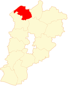
Białobłockie is a village in the administrative district of Gmina Kuźnica, within Sokółka County, Podlaskie Voivodeship, in north-eastern Poland, close to the border with Belarus.

Niezabyszewo is a village in the administrative district of Gmina Bytów, within Bytów County, Pomeranian Voivodeship, in northern Poland. It lies approximately 5 kilometres (3 mi) west of Bytów and 83 km (52 mi) west of the regional capital Gdańsk.
Zofiów is a village in the administrative district of Gmina Biała Rawska, within Rawa County, Łódź Voivodeship, in central Poland. It lies approximately 4 kilometres (2 mi) south-west of Biała Rawska, 15 km (9 mi) east of Rawa Mazowiecka, and 69 km (43 mi) east of the regional capital Łódź.
Kostki Małe is a village in the administrative district of Gmina Busko-Zdrój, within Busko County, Świętokrzyskie Voivodeship, in south-central Poland. It lies approximately 7 kilometres (4 mi) west of Busko-Zdrój and 47 km (29 mi) south of the regional capital Kielce.
Oleszki is a village in the administrative district of Gmina Busko-Zdrój, within Busko County, Świętokrzyskie Voivodeship, in south-central Poland. It lies approximately 5 kilometres (3 mi) west of Busko-Zdrój and 47 km (29 mi) south of the regional capital Kielce.
Sielec is a village in the administrative district of Gmina Wodzisław, within Jędrzejów County, Świętokrzyskie Voivodeship, in south-central Poland. It lies approximately 5 kilometres (3 mi) west of Wodzisław, 17 km (11 mi) south-west of Jędrzejów, and 52 km (32 mi) south-west of the regional capital Kielce.

Kępa Okrzewska is a village in the administrative district of Gmina Konstancin-Jeziorna, within Piaseczno County, Masovian Voivodeship, in east-central Poland. It lies approximately 7 kilometres (4 mi) north-east of Konstancin-Jeziorna, 13 km (8 mi) north-east of Piaseczno, and 14 km (9 mi) south-east of Warsaw.
Dzierżanów is a village in the administrative district of Gmina Jadów, within Wołomin County, Masovian Voivodeship, in east-central Poland.
Nowa Wieś is a village in the administrative district of Gmina Kuczbork-Osada, within Żuromin County, Masovian Voivodeship, in east-central Poland. It lies approximately 14 kilometres (9 mi) north-east of Żuromin and 121 km (75 mi) north-west of Warsaw.
Pieńki-Towarzystwo is a village in the administrative district of Gmina Radziejowice, within Żyrardów County, Masovian Voivodeship, in east-central Poland.
Borowo is a village in the administrative district of Gmina Krzykosy, within Środa Wielkopolska County, Greater Poland Voivodeship, in west-central Poland. It lies approximately 7 kilometres (4 mi) north-west of Krzykosy, 11 km (7 mi) south of Środa Wielkopolska, and 39 km (24 mi) south-east of the regional capital Poznań.

Dolędzin is a settlement in the administrative district of Gmina Rudnik, within Racibórz County, Silesian Voivodeship, in southern Poland. It lies approximately 6 kilometres (4 mi) north-west of Rudnik, 13 km (8 mi) north-west of Racibórz, and 63 km (39 mi) west of the regional capital Katowice.
Bzinica Stara is a village in the administrative district of Gmina Dobrodzień, within Olesno County, Opole Voivodeship, in south-western Poland. It lies approximately 5 kilometres (3 mi) south of Dobrodzień, 21 km (13 mi) south of Olesno, and 38 km (24 mi) east of the regional capital Opole.
Korne is a village in the administrative district of Gmina Kościerzyna, within Kościerzyna County, Pomeranian Voivodeship, in northern Poland. It lies approximately 9 kilometres (6 mi) west of Kościerzyna and 57 km (35 mi) south-west of the regional capital Gdańsk.
Malenin is a village in the administrative district of Gmina Tczew, within Tczew County, Pomeranian Voivodeship, in northern Poland. It lies approximately 5 kilometres (3 mi) north-west of Tczew and 26 km (16 mi) south of the regional capital Gdańsk.
Piwnice is a settlement in the administrative district of Gmina Tczew, within Tczew County, Pomeranian Voivodeship, in northern Poland. It lies approximately 5 kilometres (3 mi) north-west of Tczew and 26 km (16 mi) south of the regional capital Gdańsk.
Milwińska Huta is a village in the administrative district of Gmina Luzino, within Wejherowo County, Pomeranian Voivodeship, in northern Poland. It lies approximately 5 kilometres (3 mi) south-east of Luzino, 11 km (7 mi) south-west of Wejherowo, and 37 km (23 mi) north-west of the regional capital Gdańsk.
Paradyż is a village in the administrative district of Gmina Wejherowo, within Wejherowo County, Pomeranian Voivodeship, in northern Poland. It lies approximately 9 kilometres (6 mi) north-west of Wejherowo and 44 km (27 mi) north-west of the regional capital Gdańsk.