Goszcz is a village in the administrative district of Gmina Twardogóra, within Oleśnica County, Lower Silesian Voivodeship, in south-western Poland. Prior to 1945 it was in Germany.
Zła Wieś is a village in the administrative district of Gmina Dobrcz, within Bydgoszcz County, Kuyavian-Pomeranian Voivodeship, in north-central Poland. It lies 7 kilometres (4 mi) south-east of Dobrcz, 21 km (13 mi) north-east of Bydgoszcz, and 35 km (22 mi) north-west of Toruń.
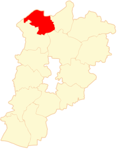
Popowo is a village in the administrative district of Gmina Wałcz, within Wałcz County, West Pomeranian Voivodeship, in north-western Poland. It lies approximately 11 kilometres (7 mi) south of Wałcz and 129 km (80 mi) east of the regional capital Szczecin.
Bubel-Łukowiska is a village in the administrative district of Gmina Janów Podlaski, within Biała Podlaska County, Lublin Voivodeship, in eastern Poland, close to the border with Belarus.
Czołnowo is a settlement in the administrative district of Gmina Supraśl, within Białystok County, Podlaskie Voivodeship, in north-eastern Poland. It lies approximately 6 kilometres (4 mi) north-east of Supraśl and 21 km (13 mi) north-east of the regional capital Białystok.
Nowodworce is a village in the administrative district of Gmina Wasilków, within Białystok County, Podlaskie Voivodeship, in north-eastern Poland. It lies approximately 3 kilometres (2 mi) south-east of Wasilków and 10 km (6 mi) north-east of the regional capital Białystok.
Czyżów is a village in the administrative district of Gmina Stopnica, within Busko County, Świętokrzyskie Voivodeship, in south-central Poland. It lies approximately 6 kilometres (4 mi) north-east of Stopnica, 20 km (12 mi) east of Busko-Zdrój, and 53 km (33 mi) south-east of the regional capital Kielce.
Zimnowoda is a village in the administrative district of Gmina Bogoria, within Staszów County, Świętokrzyskie Voivodeship, in south-central Poland. It lies approximately 3 kilometres (2 mi) southwest of Bogoria, 10 km (6 mi) northeast of Staszów, and 52 km (32 mi) south-east of the regional capital Kielce.
Uścieniec-Kolonia is a village in the administrative district of Gmina Wilga, within Garwolin County, Masovian Voivodeship, in east-central Poland.
Nowa Wola is a village in the administrative district of Gmina Grabów nad Pilicą, within Kozienice County, Masovian Voivodeship, in east-central Poland. It lies approximately 4 kilometres (2 mi) south of Grabów nad Pilicą, 27 km (17 mi) north-west of Kozienice, and 60 km (37 mi) south of Warsaw.
Hruszniew-Kolonia is a village in the administrative district of Gmina Platerów, within Łosice County, Masovian Voivodeship, in east-central Poland.
Janowo Racięckie is a village in the administrative district of Gmina Wierzbinek, within Konin County, Greater Poland Voivodeship, in west-central Poland.
Surmin is a village in the administrative district of Gmina Sośnie, within Ostrów Wielkopolski County, Greater Poland Voivodeship, in west-central Poland. It lies approximately 3 kilometres (2 mi) north-east of Sośnie, 20 km (12 mi) south of Ostrów Wielkopolski, and 115 km (71 mi) south-east of the regional capital Poznań.
Skrzynki is a village in the administrative district of Gmina Grabów nad Prosną, within Ostrzeszów County, Greater Poland Voivodeship, in west-central Poland. It lies approximately 4 kilometres (2 mi) south-east of Grabów nad Prosną, 14 km (9 mi) north-east of Ostrzeszów, and 133 km (83 mi) south-east of the regional capital Poznań.
Borowo-Młyn is a village in the administrative district of Gmina Pobiedziska, within Poznań County, Greater Poland Voivodeship, in west-central Poland. It lies approximately 5 kilometres (3 mi) south-west of Pobiedziska and 22 km (14 mi) north-east of the regional capital Poznań.
Wandów is a village in the administrative district of Gmina Władysławów, within Turek County, Greater Poland Voivodeship, in west-central Poland. It lies approximately 2 kilometres (1 mi) south of Władysławów, 9 km (6 mi) north of Turek, and 112 km (70 mi) east of the regional capital Poznań.
Batorówko is a village in the administrative district of Gmina Lipka, within Złotów County, Greater Poland Voivodeship, in west-central Poland. It lies approximately 4 kilometres (2 mi) south-east of Lipka, 22 km (14 mi) north-east of Złotów, and 123 km (76 mi) north of the regional capital Poznań.
Goraszowice is a village in the administrative district of Gmina Otmuchów, within Nysa County, Opole Voivodeship, in south-western Poland, close to the Czech border. It lies approximately 8 kilometres (5 mi) north-east of Otmuchów, 9 km (6 mi) north-west of Nysa, and 52 km (32 mi) west of the regional capital Opole.
Kolano is a village in the administrative district of Gmina Stężyca, within Kartuzy County, Pomeranian Voivodeship, in northern Poland. It lies approximately 12 kilometres (7 mi) east of Stężyca, 12 km (7 mi) south-west of Kartuzy, and 37 km (23 mi) south-west of the regional capital Gdańsk.
Trankwice is a village in the administrative district of Gmina Stary Targ, within Sztum County, Pomeranian Voivodeship, in northern Poland. It lies approximately 7 kilometres (4 mi) north-east of Stary Targ, 15 km (9 mi) east of Sztum, and 60 km (37 mi) south-east of the regional capital Gdańsk.