Walerianowo is a village in the administrative district of Gmina Wierzbinek, within Konin County, Greater Poland Voivodeship, in west-central Poland. It lies approximately 8 kilometres (5 mi) north of Wierzbinek, 35 km (22 mi) north-east of Konin, and 107 km (66 mi) east of the regional capital Poznań.
Biela is a village in the administrative district of Gmina Wilczyn, within Konin County, Greater Poland Voivodeship, in west-central Poland. It lies approximately 7 kilometres (4 mi) south-east of Wilczyn, 26 km (16 mi) north of Konin, and 90 km (56 mi) east of the regional capital Poznań.
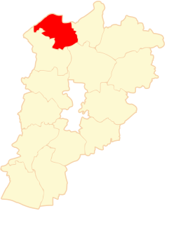
Cegielnia is a village in the administrative district of Gmina Wilczyn, within Konin County, Greater Poland Voivodeship, in west-central Poland.
Dębówiec is a village in the administrative district of Gmina Wilczyn, within Konin County, Greater Poland Voivodeship, in west-central Poland.
Gogolina is a village in the administrative district of Gmina Wilczyn, within Konin County, Greater Poland Voivodeship, in west-central Poland. It lies approximately 7 kilometres (4 mi) south-east of Wilczyn, 25 km (16 mi) north of Konin, and 88 km (55 mi) east of the regional capital Poznań.
Góry is a village in the administrative district of Gmina Wilczyn, within Konin County, Greater Poland Voivodeship, in west-central Poland. It lies approximately 10 kilometres (6 mi) south-east of Wilczyn, 23 km (14 mi) north of Konin, and 90 km (56 mi) east of the regional capital Poznań.
Kaliska is a village in the administrative district of Gmina Wilczyn, within Konin County, Greater Poland Voivodeship, in west-central Poland. It lies approximately 9 kilometres (6 mi) south of Wilczyn, 23 km (14 mi) north of Konin, and 87 km (54 mi) east of the regional capital Poznań.
Kopydłówek is a settlement in the administrative district of Gmina Wilczyn, within Konin County, Greater Poland Voivodeship, in west-central Poland.
Kopydłowo is a village in the administrative district of Gmina Wilczyn, within Konin County, Greater Poland Voivodeship, in west-central Poland. It lies approximately 5 kilometres (3 mi) south of Wilczyn, 27 km (17 mi) north of Konin, and 87 km (54 mi) east of the regional capital Poznań.
Kownaty is a village in the administrative district of Gmina Wilczyn, within Konin County, Greater Poland Voivodeship, in west-central Poland. It lies approximately 2 kilometres (1 mi) north of Wilczyn, 33 km (21 mi) north of Konin, and 86 km (53 mi) east of the regional capital Poznań.
Maślaki is a village in the administrative district of Gmina Wilczyn, within Konin County, Greater Poland Voivodeship, in west-central Poland. It lies approximately 7 kilometres (4 mi) south of Wilczyn, 26 km (16 mi) north of Konin, and 83 km (52 mi) east of the regional capital Poznań.
Mrówki is a village in the administrative district of Gmina Wilczyn, within Konin County, Greater Poland Voivodeship, in west-central Poland. It lies approximately 3 kilometres (2 mi) north-west of Wilczyn, 33 km (21 mi) north of Konin, and 84 km (52 mi) east of the regional capital Poznań.
Nowa Gogolina is a village in the administrative district of Gmina Wilczyn, within Konin County, Greater Poland Voivodeship, in west-central Poland. It lies approximately 8 kilometres (5 mi) south of Wilczyn, 24 km (15 mi) north of Konin, and 88 km (55 mi) east of the regional capital Poznań.
Ościsłowo is a village in the administrative district of Gmina Wilczyn, within Konin County, Greater Poland Voivodeship, in west-central Poland. It lies approximately 9 kilometres (6 mi) south-east of Wilczyn, 26 km (16 mi) north of Konin, and 92 km (57 mi) east of the regional capital Poznań.
Suchary is a village in the administrative district of Gmina Wilczyn, within Konin County, Greater Poland Voivodeship, in west-central Poland. It lies approximately 6 kilometres (4 mi) south of Wilczyn, 27 km (17 mi) north of Konin, and 84 km (52 mi) east of the regional capital Poznań.
Świętne is a village in the administrative district of Gmina Wilczyn, within Konin County, Greater Poland Voivodeship, in west-central Poland. It lies approximately 5 kilometres (3 mi) west of Wilczyn, 32 km (20 mi) north of Konin, and 81 km (50 mi) east of the regional capital Poznań.

Wilczyn is a village in Konin County, Greater Poland Voivodeship, in west-central Poland. It is the seat of the gmina called Gmina Wilczyn. It lies approximately 31 kilometres (19 mi) north of Konin and 86 km (53 mi) east of the regional capital Poznań.
Wiśniewa is a village in the administrative district of Gmina Wilczyn, within Konin County, Greater Poland Voivodeship, in west-central Poland. It lies approximately 8 kilometres (5 mi) south-east of Wilczyn, 25 km (16 mi) north of Konin, and 89 km (55 mi) east of the regional capital Poznań.
Zygmuntowo is a village in the administrative district of Gmina Wilczyn, within Konin County, Greater Poland Voivodeship, in west-central Poland.