
Lillooet is a district municipality in the Squamish-Lillooet region of southwestern British Columbia. The town is on the west shore of the Fraser River immediately north of the Seton River mouth. On BC Highway 99, the locality is by road about 100 kilometres (62 mi) northeast of Pemberton, 64 kilometres (40 mi) northwest of Lytton, and 172 kilometres (107 mi) west of Kamloops.
The Stʼatʼimc, also known as the Lillooet, St̓át̓imc, Stl'atl'imx, etc., are an Interior Salish people located in the southern Coast Mountains and Fraser Canyon region of the Interior of the Canadian province of British Columbia.

The Squamish-Lillooet Regional District is a quasi-municipal administrative area in British Columbia, Canada. It stretches from Britannia Beach in the south to Pavilion in the north. Lillooet, Pemberton, Whistler and Squamish are the four municipalities in the regional district. Its administrative offices are in the Village of Pemberton, although the district municipalities of Squamish and Whistler are larger population centres. The district covers 16,353.68 km² of land area.

Seton Portage is a community on a narrow strip of land between Anderson Lake and Seton Lake in Squamish-Lillooet Regional District, British Columbia. The community is home to two Seton Lake First Nation communities at either end of the portage and a non-native recreational community between them. Local services include a post office, fire department, library, and general store, among other small businesses. The community is also the location of Seton Portage Historic Provincial Park, a small provincial park protecting a historically significant stretch of railway.
Shalalth and South Shalalth are unincorporated communities on the northern shore near the western end of Seton Lake in the Squamish-Lillooet region of southwestern British Columbia. The localities are by road about 63 kilometres (39 mi) northwest of Lillooet, but only 24 kilometres (15 mi) by rail.

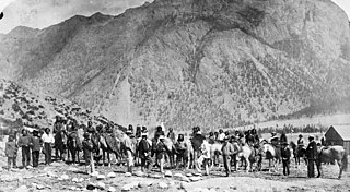
The Douglas Road, a.k.a. the Lillooet Trail, Harrison Trail or Lakes Route, was a goldrush-era transportation route from the British Columbia Coast to the Interior. Over 30,000 men are reckoned to have travelled the route in, although by the end of the 1860s it was virtually abandoned due to the construction of the Cariboo Wagon Road, which bypassed the region.

Anderson Lake is a deep lake in the Squamish-Lillooet region of southwestern British Columbia. On the northwest side are the Bendor Range and Cadwallader Range. On the southeast is the Cayoosh Range. By road, the southern end is about 47 kilometres (29 mi) northeast of Pemberton.
N'Quatqua, variously spelled Nequatque, N'quat'qua, is the proper historic name in the St'at'imcets language for the First Nations village of the Stl'atl'imx people of the community of D'Arcy, which is at the upper end of Anderson Lake about 35 miles southeast of Lillooet and about the same distance from Pemberton. The usage is synonymous with Nequatque Indian Reserve No. 1, which is 177 ha. in size and located adjacent to the mouth of the Gates River.
The Birkenhead River, formerly known as the Portage River, the Pole River and the Mosquito River, is a major tributary of the Lillooet River, which via Harrison Lake and the Harrison River is one of the major tributaries of the lower Fraser River. It is just over 50 km long from its upper reaches in the unnamed ranges south of Bralorne, British Columbia ; their western area towards the named Bendor Range east of Bralorne is sometimes called the Cadwallader Ranges.
The Bridge River Indian Band(Lillooet: nx̌ʷístǝnǝmx) also known as the Nxwísten First Nation, the Xwisten First Nation, and the Bridge River Band, is a First Nations government located in the Central Interior-Fraser Canyon region of the Canadian province of British Columbia. It is a member of the Lillooet Tribal Council, which is the largest grouping of band governments of the St'at'imc people.
Seton Portage Historic Provincial Park is a historic provincial park located in the community of Seton Portage, British Columbia, Canada. It was established on March 29, 1972 to commemorate the location of the first railway in the province of British Columbia.
The N'Quatqua First Nation, also known as the N'quatqua Nation, the N'Quatqua Nation, the Nequatque First Nation, the Anderson Lake Indian Band, the Anderson Lake First Nation and the Anderson Lake Band, is a First Nations government of the St'at'imc people, located in the southern Coast Mountains region of the Canadian province of British Columbia at the community of D'Arcy, where the British Columbia Railway meets the head of Anderson Lake, about midway between the towns of Pemberton and Lillooet.
The Lillooet Country, also referred to as the Lillooet District, is a region spanning from the central Fraser Canyon town of Lillooet west to the valley of the Lillooet River, and including the valleys in between, in the Southern Interior of British Columbia. Like other historical BC regions, it is sometimes referred to simply as The Lillooet or even Lillooet,.
The Lakes Route is an alternate name for the Douglas Road, which was the first formally designated "road" into the Interior of British Columbia, Canada from its Lower Mainland area flanking the Lower Fraser River. Also known as the Douglas-Lillooet Trail or the Lillooet Trail, the route consisted of a series of wagon roads connected via lake travel in between. A variety of craft were used on the lakes, from steamboats to sail-driven rafts to, through the early 20th Century, diesel and other engines. Lake travel continued for commerce, passenger travel and heavy freight until after World War II.
Pemberton Pass, 505 m (1,657 ft), also formerly known as Mosquito Pass, is the lowest point on the divide between the Lillooet and Fraser River drainages, located at Birken, British Columbia, Canada, in the principal valley connecting and between Pemberton and Lillooet. The pass is a steep-sided but flat-bottomed valley adjacent to Mount Birkenhead and forming a divide between Poole Creek, a tributary of the Birkenhead River, which joins the Lillooet at Lillooet Lake, and the Gates River which flows northeast from Gates Lake, at the summit of the pass, which flows to the Fraser via Anderson and Seton Lakes and the Seton River.
McGillivray, formerly McGillivray Falls, is an unincorporated recreational community on the west shore of Anderson Lake, just east of midway between the towns of Pemberton and Lillooet, British Columbia, Canada, in that province's southwest Interior.
Devine is a rural locality located in the Gates Valley of the Lillooet Country in the southwestern Interior of British Columbia, Canada, about 3 km (2 mi) from D'Arcy, at the head of Anderson Lake.
The Gates River is a short river in the Lillooet Country of the Southern Interior of British Columbia, Canada. Approximately 14.5 km in length, it flows generally northeast from the outlet of Birken Lake to its mouth at the head of Anderson Lake. Its main tributaries are Haylmore Creek, from the southeast, and Blackwater Creek, from the northwest, which originates near the head of Birkenhead Lake. Augmented by the waters of McGillivray Creek, Lost Valley Creek and others, its flow becomes the Seton River from the foot of Anderson Lake onwards.
Birken is an unincorporated community on the north shore of Gates Lake in the Squamish-Lillooet region of southwestern British Columbia. On Pemberton Portage Road, the locality is by road about 182 kilometres (113 mi) north of Vancouver and 62 kilometres (39 mi) northeast of Whistler.
The Gates Valley is a valley and group of communities in the Lillooet Country of the Southern Interior of British Columbia, Canada, located between the summit of Pemberton Pass and the head of Anderson Lake at the community of D'Arcy. Though the term strictly refers to the valley of the Gates River, it is usually used more in a sense of the communities located in the valley and is not a term used for the river's drainage basin, which is much larger.
