
Tourism in Albania has been a key element to the country's economic activity and is constantly developing. Albania is characterized by its rich archaeological and cultural heritage dating back to the classical period when Illyrians and Ancient Greeks inhabited the region. Over the course of history, the territory of Albania was occupied and populated by Romans, Byzantines, Venetians and Ottomans. Notably the country features unspoiled beaches, mountainous landscapes, traditional cuisine, archaeological artifacts, unique traditions, low prices and the wild atmosphere of the countryside.

Lezhë is a city in the Republic of Albania and seat of Lezhë County and Lezhë Municipality. It is one of Albania's continuously inhabited cities, with roughly 2,400 years of recorded history.

Tirana County, officially the County of Tirana, is a county in the Central Region of Albania. It is the tenth largest by area and the most populous of the twelve counties, with more than 912,000 people within an area of 1,652 km2 (638 sq mi). The county borders on the Adriatic Sea to the west, the counties of Durrës to the northwest, Dibër to the northeast, Elbasan to the east and Fier to the southwest. It is divided into five municipalities, Tirana, Kamëz, Kavajë, Rrogozhinë and Vorë, with all of whom incorporate twenty-nine administrative units.

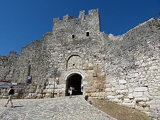
Rozafa Castle or Shkodër Castle is a castle near the city of Shkodër, in northwestern Albania. It rises imposingly on a rocky hill, 130 metres (430 ft) above sea level, surrounded by the Buna and Drin rivers. Shkodër is the seat of Shkodër County, and is one of Albania's oldest and most historic towns, as well as an important cultural and economic centre.
Berat Castle, also referred to as the Citadel of Berat and castle quarter, is a fortress overlooking the town of Berat, Albania. It dates mainly from the 13th century and contains many Byzantine churches in the area and Ottoman mosques. It is built on a rocky hill on the right bank of the river Osum and is accessible only from the south. It is situated at an elevation of 214 metres (702 ft).
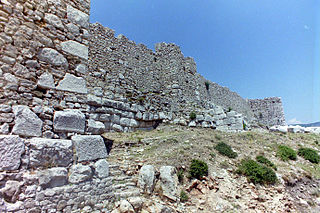
The Lezhë Castle is a castle dominating the city of Lezhë, northern Albania. Its highest point is 186 metres (610 ft). Lezhë Castle is at an elevation of 322 metres (1,056 ft). Lezhë Castle began as a Illyrian fortification. It was rebuilt by the Venetians in the 1440s and the Ottomans in 1522. In the late Middle Ages, the castle belonged to the Dukagjini family. The two brothers Tanush Thopia and Progon Dukagjini through an agreement which preserved their trade rights and estates around the castle placed the city and the castle under Venetian control in 1393 as a means to defend it against Ottoman expansion. The Venetians formally ceded the castle to the Ottomans in 1506.
Fortress of Justinian or simply known as Tirana Castle is a castle in Tirana, Albania. Its history dates back before 1300 and is a remnant from the Byzantine-era. The fortress is the place where the main east–west and north–south roads crossed, and formed the heart of Tirana. The current fortification has three known towers and it is undergoing a process of restoration, for touristic purposes. Inside the fortified walls of the former fortress, there are many buildings that can be visited, including restaurants, hotels, and cultural institutions.
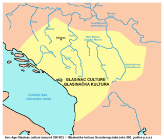
The Glasinac-Mati culture is an archaeological culture, which first developed during the Late Bronze Age and Early Iron Age in the western Balkan Peninsula in an area which encompassed much of modern Albania to the south, Kosovo to the east, Montenegro, southeastern Bosnia and Herzegovina and parts of western Serbia to the north. It is named after the Glasinac and Mati type site areas, located in Bosnia-Herzegovina and Albania respectively.

Dajti Mountain National Park is a national park established in 1966 in central Albania, spanning an area of 293.84 km2 (113.45 sq mi) since 2006. The park is 40 km (25 mi) east of the Adriatic Sea and 26 km (16 mi) east of Tirana. The area is under shared jurisdiction between Albanian Agency of Protected Areas (AKZM) and Tirana Municipality Parks and Recreation Agency (APR). It is adjacent to Shtamë Pass Nature Park to the northwest, Kraste-Verjon Protected Landscape to the west, and Mali me Gropa-Bizë-Martanesh Protected Landscape to the east. The park is marked by an extremely fragmented, rugged topography which creates favourable conditions for a great diversity of ecosystems and biodiversity.

The Illyrian Tombs of Selca e Poshtme are located near the town of Pogradec in Albania near the village of Selcë e Poshtme. On the right bank of the river Shkumbin at an elevation of 1040 m above sea level, lie the remains of the ancient city of Pelion and the accompanying necropolis. The Roman Via Egnatia led past it towards Thessaloniki. Though there are traces of human activity in Neolithic times, the settlement proper dates to the Iron Age through to the Illyrian urban period, and reached its height under settlement by the Illyrian tribe of Enchele in the later Iron Age and was also occupied in the Roman period as traces of a municipal building show. From the 4th to 1st centuries BC the city was the royal residence of Illyrian kings and therefore, also probably an important political and economic centre. In 1996, Albania included the Royal tombs of Selca e Poshtme in the UNESCO World heritage list of proposals.
Kratul was an Illyrian settlement and fortification located in the territories of the Illyrian tribe of Labeates. The archaeological material indicates that life at the settlement was active from the early Iron Age until the 1st century AD. In the modern era it is the name of a city situated in Albania, north of Boks.
Tirana is the capital and the largest city of Albania. Modern Tirana was founded as an Ottoman town in 1614 by Sulejman Bargjini, a local ruler from Mullet, although the area has been continuously inhabited since antiquity. Tirana became Albania's capital city in 1920 and has a population of over 600,000. The city is home to many universities and is the center of the political, economical, and cultural life of the country.

Blagaj Fortress or Old Town of Blagaj, locally known as Stjepan-grad (Стјепан-град), or Stipan-grad, in classical times Bona (Бона), is a town-fortress complex near the town of Blagaj, Bosnia and Herzegovina. The old Blagaj Fort was built on a high, inaccessible karst hill, at an elevation of 310 metres (1,020 ft) above sea level and 266 metres (873 ft) above the source of the river Buna. Blagaj Fort is 275 metres (902 ft) above sea level. Fortress is National monument of Bosnia and Herzegovina, declared by KONS on 6 December 2003.
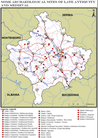
Part of series of articles upon Archaeology of Kosovo
Vlashnjë is a village in the Prizren municipality of Kosovo. It has 1,700 inhabitants as of 2011. Vlashnjë is a multi-layered settlement and site area. Archaeological excavations have identified habitation and use of the area since the Neolithic era. The rock art paintings at Mrrizi i Kobajës are the first find of prehistoric rock art in Kosovo. In late antiquity, Vlashnja was a fortified settlement part of the fortification network which Justinian I rebuilt along the White Drin in Dardania.

The Fortress of Bashtovë is a medieval quadrangular fortress located close to the outflow of the Shkumbin River into the Adriatic Sea in central Albania. It is part of the tentative list of Albania in order to qualify for inclusion in the UNESCO World Heritage Site list.

The architecture of Albania is a reflection of Albania's historical and cultural heritage. The country's architecture was influenced by its location within the Mediterranean Basin and progressed over the course of history as it was once inhabited by numerous civilisations including the Illyrians, Ancient Greeks, Romans, Byzantines, Venetians, Ottomans as well as modern Austro-Hungarians and Italians. In addition, missionaries, invaders, colonisers and traders brought cultural changes that had a large profound effect on building styles as well as techniques.
There are many landmarks in Tirana, Albania some of which are of considerable historical or artistic interest. Many monuments and landmarks situated in Tirana, date back to the Illyrian, Roman, Greek and Ottoman periods.

The Dardana Fortress is an archaeological site of the Bronze Age, Iron Age and late antiquity in eastern Kosovo. It is located on a hill to the northwest of Kamenica. It was a hilltop settlement and fortress of the Dardani in classical antiquity. It was rebuilt in the late Roman period as part of the fortification system in the Roman province of Dardania. The site was discovered in the 1970s, but excavations did not start in earnest until 2012. One of the very earliest finds at the site is a funerary stele found accidentally at the foot of the hill in 1992. Its interpretation has helped shed light on Illyrian burial customs, and excavations at the site have contributed to knowledge about the trade patterns between Dardania and the Mediterranean region. Similar sites have been discovered in recent years in the Kamenica region.

The Cultural heritage of Albania is a blend of ancient traditions and historical influences that come together in Albania to create a rich mosaic of culture and history.
