Kurwai is a town and a Nagar Panchayat in Vidisha district in the Indian state of Madhya Pradesh. its also tehsil headquarter and assembly constituency.

Baldeogarh is a town and a nagar panchayat in Tikamgarh district in the state of Madhya Pradesh, India. It's also a Tehsil Headquarter.
Bhainsdehi is a city and a Nagar Parishad in Betul district in the state of Madhya Pradesh, India. Kukru is the second highest point of Mahadeo hills. Bhainsdehi is the originating place of the river Purna. It is predominantly a tribal tehsil. Bhainsdehi is surrounded by the mountain ranges of Satpura. Prachin Shiv mandir one of the most beautiful place in Bhainsdehi city
Bhander is a town and a nagar panchayat in Datia district in the state of Madhya Pradesh.
Chourai is a town and a nagar panchayat in Chhindwara district in the state of Madhya Pradesh, India.
Kasrawad is a tehsil and nagar panchayat in Khargone district in the Indian state of Madhya Pradesh. Kasrawad Assembly constituency is one of the 230 Vidhan Sabha constituencies of Madhya Pradesh state in central India.
Makronia is a municipality in Sagar district in the Indian state of Madhya Pradesh. Its part of Sagar Urban Agglomeration.
Malhargarh is a town and a tehsil in Mandsaur district in the Indian state of Madhya Pradesh. It is located between Neemuch and Mandsaur on the Ratlam- Chittaurgarh Section of Indian railway. Malhargarh is rich in agriculture and part of the Malwa region.
Meghnagar is a City Council and a Tehsil Headquarter in Jhabua district in the India state of Madhya Pradesh.

Nainpur is a town and Municipal City in the Mandla district, of the Indian state of Madhya Pradesh.
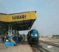
Niwari is a town and a nagar panchayat in Niwari district in Indian state of Madhya Pradesh. It is the administrative headquarter of Niwari district.
Piplia Mandi is a town and a Nagar Parishad in Mandsaur district in the Indian state of Madhya Pradesh. It is15 km away from the city of Mandsaur on state highway 31.
Shamgarh is a City and a nagar parishad in Mandsaur district in the Indian state of Madhya Pradesh. Shamgarh is located at 24.18°N 75.63°E.
Tendu Kheda is a town and a Nagar Panchayat in Damoh district in the Indian state of Madhya Pradesh. It's also a Tehsil Headquarter.

Ghoradhongri is a town and a Nagar Parishad in Betul District of Madhya Pradesh. Its also a Tehsil Headquarter and Assembly constituency.
Shahpura or Shahpura Bhitoni is a town and a nagar panchayat in Jabalpur district in the Indian state of Madhya Pradesh.
Narayangarh is a nagar panchayat city in district of Mandsaur, Madhya Pradesh. The city is divided into 15 wards for which elections are held every 5 years. The Narayangarh Nagar Panchayat has population of 10,191 of which 5,168 are males while 5,023 are females as per report released by Census India 2011.
Barhi is a town,Tehsil and a Nagar Parishad in Katni district in the state of Madhya Pradesh, India.
Jawar is a nagar panchayat and a town in Sehore District of Madhya Pradesh, India. It is also a tehsil.
Suwasra is a town and a Nagar Parishad in Mandsaur District of Madhya Pradesh. It's also a Tehsil Headquarter And Assembly Constituency.


