Related Research Articles
The United Nations Convention on the Law of the Sea (UNCLOS), also called the Law of the Sea Convention or the Law of the Sea Treaty, is an international agreement that establishes a legal framework for all marine and maritime activities. As of May 2023, 168 countries and the European Union are parties.

The East China Sea is a marginal sea of the Western Pacific Ocean, located directly offshore from East China. China names the body of water along its eastern coast as "East Sea" due to direction, the name of "East China Sea" is otherwise designated as formal name by International Hydrographic Organization(IHO) and used internationally.

The terms international waters or transboundary waters apply where any of the following types of bodies of water transcend international boundaries: oceans, large marine ecosystems, enclosed or semi-enclosed regional seas and estuaries, rivers, lakes, groundwater systems (aquifers), and wetlands.

Territorial waters are informally an area of water where a sovereign state has jurisdiction, including internal waters, the territorial sea, the contiguous zone, the exclusive economic zone, and potentially the extended continental shelf. In a narrower sense, the term is often used as a synonym for the territorial sea.

Law of the sea is a body of international law governing the rights and duties of states in maritime environments. It concerns matters such as navigational rights, sea mineral claims, and coastal waters jurisdiction.

An exclusive economic zone (EEZ), as prescribed by the 1982 United Nations Convention on the Law of the Sea, is an area of the sea in which a sovereign state has exclusive rights regarding the exploration and use of marine resources, including energy production from water and wind. EEZ does not define the ownership of any maritime features within the EEZ.

The Malaysia–Thailand border divides the sovereign states of Malaysia and Thailand and consists of a land boundary running for 595 km across the Malay Peninsula and maritime boundaries in the Straits of Malacca and the Gulf of Thailand/South China Sea. The Golok River forms the easternmost 95 km stretch of the land border.
Ambalat is a sea block in the Celebes sea located off the east coast of Borneo. It lies to the east of the Indonesian province of North Kalimantan and to the south-east of the Malaysian state of Sabah, and it is the subject of a territorial dispute between the two nations. Malaysia refers to part of the Ambalat block as Block ND6 (formerly Block Y) and part of East Ambalat Block as Block ND7 (formerly Block Z). The deep sea blocks contain an estimated 62,000,000 barrels (9,900,000 m3) of oil and 348 million cubic meters of natural gas. Other estimates place it substantially higher: 764,000,000 barrels (121,500,000 m3) of oil and 3.96 × 10¹⁰ cubic meters (1.4 trillion cubic feet) of gas, in only one of nine points in Ambalat.
The natural prolongation principle or principle of natural prolongation is a legal concept introduced in maritime claims submitted to the United Nations.
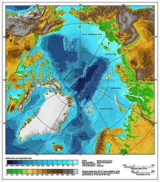
The Arctic consists of land, internal waters, territorial seas, exclusive economic zones (EEZs) and international waters above the Arctic Circle. All land, internal waters, territorial seas and EEZs in the Arctic are under the jurisdiction of one of the eight Arctic coastal states: Canada, Denmark, Finland, Iceland, Norway, Russia, Sweden and the United States. International law regulates this area as with other portions of Earth.
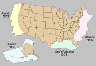
The Outer Continental Shelf (OCS) is legally defined geographic feature of the United States. The OCS is the part of the internationally recognized continental shelf of the United States which does not fall under the jurisdictions of the individual U.S. states.

The Brunei–Malaysia border divides the territory of Brunei and Malaysia on the island of Borneo. It consists of a 266 km (165 mi) land border and substantial lengths of maritime borders stretching from the coastline of the two countries to the edge of the continental shelf in the South China Sea.
Malaysia and Vietnam are two Southeast Asian countries with maritime boundaries which meet in the Gulf of Thailand and South China Sea. The two countries have overlapping claims over the continental shelf in the Gulf of Thailand. Both countries have, however, come to an agreement to jointly exploit the natural resources in the disputed area pending resolution of the dispute over sovereignty.

The Australia–Indonesia border is a maritime boundary running west from the two countries' tripoint maritime boundary with Papua New Guinea in the western entrance to the Torres Straits, through the Arafura Sea and Timor Sea, and terminating in the Indian Ocean. The boundary is, however, broken by the Timor Gap, where Australian and East Timorese territorial waters meet and where the two countries have overlapping claims to the seabed.
A maritime boundary is a conceptual division of Earth's water surface areas using physiographical or geopolitical criteria. As such, it usually bounds areas of exclusive national rights over mineral and biological resources, encompassing maritime features, limits and zones. Generally, a maritime boundary is delineated at a particular distance from a jurisdiction's coastline. Although in some countries the term maritime boundary represents borders of a maritime nation that are recognized by the United Nations Convention on the Law of the Sea, maritime borders usually serve to identify the edge of international waters.
The equidistance principle, or principle of equidistance, is a legal concept in maritime boundary claims that a nation's maritime boundaries should conform to a median line that is equidistant from the shores of neighboring nations. The concept was developed in the process of settling disputes in which the borders of adjacent nations were located on a contiguous continental shelf:
An equidistance line is one for which every point on the line is equidistant from the nearest points on the baselines being used. The equidistance principle is a methodology that has been endorsed by the United Nations Convention on the Law of the Sea but predates that treaty and has been used by the Supreme Court of the United States, states, and nations to establish boundaries equitably.

There are disputes between China, Japan, Taiwan and South Korea over the extent of their respective exclusive economic zones (EEZs) in the East China Sea.
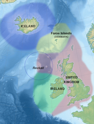
Several states have claimed interests over the sea bed adjoining Rockall, an uninhabitable granite islet which is located within the exclusive economic zone (EEZ) of the United Kingdom. Ireland, Denmark, Iceland, and the United Kingdom have all made submissions to the commission set up under the United Nations Convention on the Law of the Sea (UNCLOS).

The exclusive economic zone of Somalia covers 830,389 km2 in the Indian Ocean. It extends to a distance of 200 nautical miles from the baselines, from which the breadth of the nation's territorial waters is measured. In accordance with Law No. 37 passed in 1972, Somalia's EEZ falls under its territorial sovereignty.
The borders of Indonesia include land and maritime borders with Malaysia, Papua New Guinea, and East Timor, as well as shared maritime boundaries with Australia, India, Palau, Philippines, Singapore, Thailand, and Vietnam.
References
- Dallmeyer, Dorinda G. and Louis De Vorsey. (1989). Rights to Oceanic Resources: Deciding and Drawing Maritime Boundaries. Dordrecht: Martinus Nijhoff Publishers. ISBN 9780792300199; OCLC 18981568
| International | |
|---|---|
| National | |
| | This biographical article about a geographer is a stub. You can help Wikipedia by expanding it. |