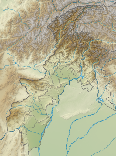
Waziristan is a mountainous region covering the North Waziristan and South Waziristan districts of the Pakistani province of Khyber Pakhtunkhwa. Waziristan covers around 11,585 square kilometres (4,500 sq mi) and is mainly populated by the Wazir Pashtun tribe, who speak the Waziri dialect of the Pashto language.

North Waziristan District is a district of Khyber Pakhtunkhwa province in Pakistan. It is the northern part of Waziristan, a mountainous region of northwest Pakistan, bordering Afghanistan and covering 4,707 square kilometres (1,817 sq mi). The capital city of North Waziristan is Miranshah.

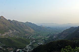
South Waziristan District was a district in the Dera Ismail Khan Division of the Khyber Pakhtunkhwa province before splitting into the Lower South Waziristan District and the Upper South Waziristan District on April 13, 2022. It covers around 11,585 km2 (4,473 mi2). Waziristan is located in the southwest of Khyber Pakhtunkhwa. It is situated between two rivers. The Tochi River is flowing on its north and the Gomal River is flowing on its south. The region was an independent tribal territory from 1893, separated from both Afghanistan the British-ruled empire in the subcontinent. Raiding the tribal areas was a constant problem for the British, requiring frequent punitive expeditions between 1860 and 1945. Troops of the British Raj coined a name for this region "Hell's Door Knocker" in recognition of the fearsome reputation of the local fighters and inhospitable terrain. The district headquarter of the South Waziristan district is Wanna. South Waziristan is divided into three administrative subdivisions of Ladha, Sarwakai, and Wanna. These three subdivisions are further divided into eight Tehsils: Ladha, Makin, Sararogha, Sarwakai, Tiarza, Wanna, Barmal, and Toi Khula.

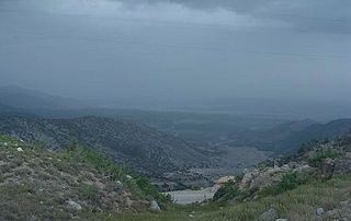
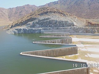
Gomal Zam Dam is a multi-purpose gravity dam in South Waziristan Tribal District of Khyber Pakhtunkhwa, Pakistan. The dam impounds the Gomal River, a tributary of the Indus River, at Khjori Kach, where the Gomal River passes through a narrow ravine. The purpose of the dam is irrigation, flood control, and hydroelectric power generation. Construction of the dam began in August 2001 and was completed in April 2011. The powerhouse was completed in March 2013 and electricity production started in August 2013. The dam was officially inaugurated on 12 September 2013 by Minister for Water and Power Khawaja Muhammad Asif, along with US Ambassador Richard G. Olson and Khyber Pakhtunkhwa Governor Shaukatullah Khan.
Malakand District is a district in the Malakand Division of the Khyber Pakhtunkhwa province of Pakistan.

Bannu Division is one of seven divisions in Pakistan's Khyber Pakhtunkhwa province. It consists of three districts: Bannu, Lakki Marwat, and North Waziristan. According to the 2017 Pakistani Census, the division had a population of 2,656,801, making it the least populous division in the province, but it spans 9,975 km2 (3,851 sq mi) of area, and this makes it the third-smallest division by area in the province. Lakki Marwat is the largest city of Bannu Division, with around 60,000 people, while the division's namesake and second-largest city is Bannu, with just under 50,000 people. The division borders Dera Ismail Khan Division to the south and west, Kohat Division to the north and east, and the province of Punjab, Pakistan to its east.
Kurram District is a district in the Kohat Division of the Khyber Pakhtunkhwa province of Pakistan.The name Kurram comes from the river Kwarma in Pashto which itself derives from the Sanskrit word Krumuḥ.

The insurgency in Khyber Pakhtunkhwa, also known as the War in North-West Pakistan or Pakistan's war on terror, is an ongoing armed conflict involving Pakistan and Islamist militant groups such as the Tehrik-i-Taliban Pakistan (TTP), Jundallah, Lashkar-e-Islam (LeI), TNSM, al-Qaeda, and their Central Asian allies such as the ISIL–Khorasan (ISIL), Islamic Movement of Uzbekistan, East Turkistan Movement, Emirate of Caucasus, and elements of organized crime. Formerly a war, it is now a low-level insurgency as of 2017.
The Federally Administered Tribal Areas, commonly known as FATA, was a semi-autonomous tribal region in north-western Pakistan that existed from 1947 until being merged with the neighbouring province of Khyber Pakhtunkhwa in 2018 through the Twenty-fifth amendment to the constitution of Pakistan. It consisted of seven tribal agencies (districts) and six frontier regions, and were directly governed by the federal government through a special set of laws called the Frontier Crimes Regulations.
The Kurram Tangi Dam is a multipurpose dam under construction on the Kaitu River in North Waziristan, Pakistan, with a 83.4 MW power generation capacity.
Bara Dam is a proposed small, low-head, earth core rockfill, hydroelectric dam with a capacity of 5.8 megawatts, located across Bara River at the confluence of Mastura River in Tirah Valley, Khyber Agency, FATA, Pakistan. It is part of a wider plan that consists in remodeling the Bara River, to promote agriculture.
Dandy Dam is small earth-filled dam in what was previously the North Waziristan District of the Khyber Pakhtunkhwa, Pakistan.
Zao Dam is a small earth core rock-fill dam in Khyber Agency of FATA, Pakistan.
Sheen Kach Dam is small dam in Frontier Region Tank of FATA, Pakistan.
Moto Shah Dam is small earth core rock-fill dam operational in Mohmand Agency of FATA, Pakistan.
Kand Dam is small earth core rock-fill dam in North Waziristan Agency of FATA, Pakistan.
Raghagan Dam is a concrete gravity dam under construction 13 kilometers East of Khaar town, Bajaur District of FATA, Pakistan.
Gandao Dam, officially Abdul Shakoor Dam since December 2019, is a gravity dam built near town of Ghalanai in Mohmand Agency of FATA, Pakistan. It was initially is expected to complete in 2015, with projected cost of PKR 449 Millions.