Waziristan is a mountainous region covering the North Waziristan and South Waziristan districts of the Pakistani province of Khyber Pakhtunkhwa. Waziristan covers around 11,585 square kilometres (4,500 sq mi) and is mainly populated by the Wazir Pashtun tribe, who speak the Waziri dialect of the Pashto language.

North Waziristan District is a district of Khyber Pakhtunkhwa province in Pakistan. It is the northern part of Waziristan, a mountainous region of northwest Pakistan, bordering Afghanistan and covering 4,707 square kilometres (1,817 sq mi). The capital city of North Waziristan is Miranshah.

Tarbela Dam is an earth-filled dam along the Indus River in Pakistan's Khyber Pakhtunkhwa province. It is located mainly in the Swabi District Tehsil Topi of the province. It is about 20 km (10 mi) from the city of Swabi KPK, 105 km (65 mi) northwest of Islamabad, and 125 km (80 mi) east of Peshawar. It is the largest earth-filled dam in the world. The dam is 143 metres (470 ft) high above the riverbed and its reservoir, Tarbela Lake, has a surface area of approximately 250 square kilometres (97 sq mi).
Mīrānshāh (Pashto: میران شاه) is a small town that is the administrative headquarters of North Waziristan District, Khyber Pakhtunkhwa province of Pakistan. Miranshah lies on the banks of the Tochi River in a wide valley surrounded by the foothills of the Hindu Kush mountains. It is located at an elevation of about 930 metres (3,050 ft), 17 kilometres (11 mi) from the Pakistan-Afghanistan border. The nearest city in Pakistan is Bannu, about 55 kilometres (34 mi) to the east, while the nearest city across the border in Afghanistan is Khost, 60 kilometres (37 mi) to the northwest.

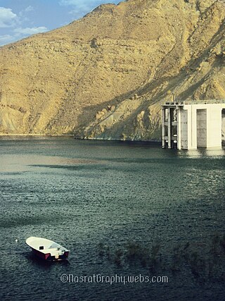
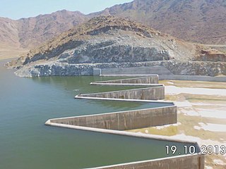
Gomal Zam Dam is a multi-purpose gravity dam in South Waziristan Tribal District of Khyber Pakhtunkhwa, Pakistan. The dam impounds the Gomal River, a tributary of the Indus River, at Khjori Kach, where the Gomal River passes through a narrow ravine. The purpose of the dam is irrigation, flood control, and hydroelectric power generation. Construction of the dam began in August 2001 and was completed in April 2011. The powerhouse was completed in March 2013 and electricity production started in August 2013. The dam was officially inaugurated on 12 September 2013 by Minister for Water and Power Khawaja Muhammad Asif, along with US Ambassador Richard G. Olson and Khyber Pakhtunkhwa Governor Shaukatullah Khan.
Miraani Dam. Dasht River south of the Central Makran Range in Kech District in Balochistan province of Pakistan. Its 302,000 acre-feet (373,000,000 m3) reservoir is fed by the Kech River and the Nihing River. Mirani Dam was completed in July 2006 and began impounding the Dasht River in August 2006.

Satpara Dam is a medium-size multi-purpose concrete-faced earth-filled dam located downstream from Satpara Lake on the Satpara Stream approximately 4 km from the town of Skardu in Gilgit-Baltistan, Pakistan.
Kurram District is a district in the Kohat Division of the Khyber Pakhtunkhwa province of Pakistan.The name Kurram comes from the river Kwarma in Pashto which itself derives from the Sanskrit word Krumuḥ.
Diamer-Bhasha Dam is a concreted-filled gravity dam, in the preliminary stages of construction, on the River Indus between Kohistan district in Khyber Pakhtunkhwa and Diamer district in Gilgit Baltistan, Pakistan administered Kashmir. Its foundation stone was laid by the then Prime Minister of Pakistan in 1998. The dam site is situated near a place called "Bhasha", hence the name which is 40 km downstream of Chilas town and 315 km from Tarbela Dam. The eight million acre feet (MAF) reservoir with 272-metre height will be the tallest roller compact concrete (RCC) dam in the world.
Hingol Dam is a proposed small, low-head, Central Core Zone, hydroelectric power generation dam of 3.5 megawatt (MW) generation capacity, located in the Lasbela District across the Hingol River in the Balochistan province of Pakistan. It is located at a distance of 260 km (162 mi) northwest of Karachi and about 16 km (10 mi) north of bridge across the Hingol River on the Makran Coastal Highway and about 8 km (5 mi) north of Kund Malir where the river falls into the sea.
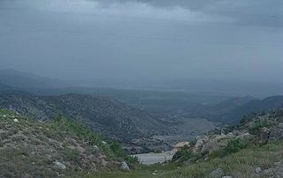
The Kurram Tangi Dam is a multipurpose dam under construction on the Kaitu River in North Waziristan, Pakistan, with a 83.4 MW power generation capacity.
Bara Dam is a proposed small, low-head, earth core rockfill, hydroelectric dam with a capacity of 5.8 megawatts, located across Bara River at the confluence of Mastura River in Tirah Valley, Khyber Agency, FATA, Pakistan. It is part of a wider plan that consists in remodeling the Bara River, to promote agriculture.
Dargai Pal Dam is an earth filled dam in South Waziristan district of Khyber Pakhtunkhwa, Pakistan.
Dandy Dam is small earth-filled dam in what was previously the North Waziristan District of the Khyber Pakhtunkhwa, Pakistan.
Zao Dam is a small earth core rock-fill dam in Khyber Agency of FATA, Pakistan.
Sheen Kach Dam is small dam in Frontier Region Tank of FATA, Pakistan.
Moto Shah Dam is small earth core rock-fill dam operational in Mohmand Agency of FATA, Pakistan.
Raghagan Dam is a concrete gravity dam under construction 13 kilometers East of Khaar town, Bajaur District of FATA, Pakistan.
Gandao Dam, officially Abdul Shakoor Dam since December 2019, is a gravity dam built near town of Ghalanai in Mohmand Agency of FATA, Pakistan. It was initially is expected to complete in 2015, with projected cost of PKR 449 Millions.

